
Zamora topographic map
Interactive map
Click on the map to display elevation.
About this map
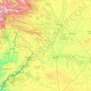
Name: Zamora topographic map, elevation, terrain.
Location: Zamora, Castile and León, Spain (41.11717 -7.03404 42.25418 -5.22887)
Average elevation: 803 m
Minimum elevation: 192 m
Maximum elevation: 2,162 m
Other topographic maps
Click on a map to view its topography, its elevation and its terrain.
Yacimiento arqueológico La Edrada
Spain > Castile and León > El Bierzo > Cacabelos
Average elevation: 493 m
Poblado del Salto de Aldeadávila
Spain > Castile and León > Aldeadávila de la Ribera
Average elevation: 535 m
Castrillo Mota de Judíos
Spain > Castile and León > Castrillo Mota de Judíos > Castrillo Mota de Judíos
Average elevation: 801 m