
Ağaçören topographic map
Interactive map
Click on the map to display elevation.
About this map
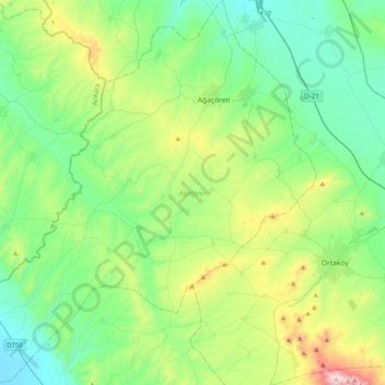
Name: Ağaçören topographic map, elevation, terrain.
Location: Ağaçören, Aksaray, Central Anatolia Region, Turkey (38.63750 33.64360 38.94845 34.02228)
Average elevation: 1,212 m
Minimum elevation: 911 m
Maximum elevation: 2,125 m
Other topographic maps
Click on a map to view its topography, its elevation and its terrain.
Cappadocia
Turkey > Central Anatolia Region > Göreme
The area was featured in several films due to its topography. The 1983 Italian/French/Turkish film Yor, the Hunter from the Future was filmed in Cappadocia. The region was used for the 1989 science fiction film Slipstream to depict a cult of wind worshippers. In 2010 and early 2011, the film Ghost Rider:…
Average elevation: 1,144 m