
Tuscarawas County topographic map
Interactive map
Click on the map to display elevation.
About this map
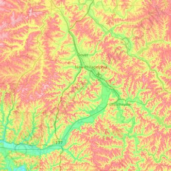
Name: Tuscarawas County topographic map, elevation, terrain.
Location: Tuscarawas County, Ohio, United States (40.21442 -81.71234 40.66572 -81.26426)
Average elevation: 312 m
Minimum elevation: 226 m
Maximum elevation: 412 m
Other topographic maps
Click on a map to view its topography, its elevation and its terrain.
Columbus
United States > Ohio > Franklin County > Columbus
The confluence of the Scioto and Olentangy rivers is just north-west of Downtown Columbus. Several smaller tributaries course through the Columbus metropolitan area, including Alum Creek, Big Walnut Creek, and Darby Creek. Columbus is considered to have relatively flat topography thanks to a large glacier that…
Average elevation: 255 m
Schoenbrunn Estates
United States > Ohio > Tuscarawas County > New Philadelphia
Average elevation: 283 m
Pine Ridge Trailer Park
United States > Ohio > Lorain County > North Ridgeville
Average elevation: 228 m
French Park
United States > Ohio > Hamilton County > Amberley Village > Rolling Knolls Estate
Average elevation: 235 m
Nature Center at The Summit
United States > Ohio > Hamilton County > Cincinnati
Average elevation: 173 m