
Salamanca topographic map
Click on the map to display elevation.
Salamanca
With an altitude of over 800 meters, Salamanca has a warm-summer Mediterranean climate (Csb) according to the Köppen climate classification, with some cold semi-arid climate (BSk) climatic influences, resulting in large diurnal temperature variations, with hot summers and chilly winters, and nearly-semi-arid levels of precipitation. Salamanca does not have a real wet season. Most of the precipitation falls outside of the summer, with upticks at the end of the spring and during the winter; all winters have snow during few days per year, although heavy snowfalls are uncommon, but not unheard of. The city averages around 7 days of snowy days per year, morning frost during winters is very common, as on a normal year, Salamanca has on average 76 days with low temperatures below freezing.
About this map
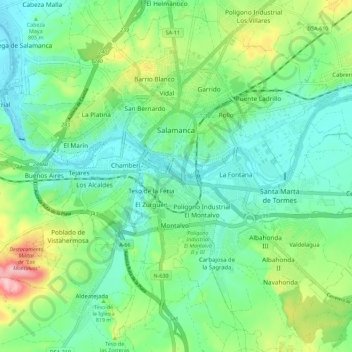
Name: Salamanca topographic map, elevation, terrain.
Location: Salamanca, Castile and León, Spain (40.91463 -5.73580 40.99319 -5.62262)
Average elevation: 812 m
Minimum elevation: 763 m
Maximum elevation: 935 m
Other topographic maps
Click on a map to view its topography, its elevation and its terrain.
Sierra de Guadarrama
The range runs southwest–northeast, extending from the province of Ávila in the southwest, through the Community of Madrid, to the province of Segovia in the northeast. The range measures approximately 80 kilometres (50 mi) in length. Its highest peak is Peñalara, 2,428 metres (7,966 ft) in elevation.
Average elevation: 1,153 m
Yacimiento arqueológico La Edrada
Spain > Castile and León > El Bierzo > Cacabelos
Average elevation: 493 m
Poblado del Salto de Aldeadávila
Spain > Castile and León > Aldeadávila de la Ribera
Average elevation: 535 m