
Salamanca topographic map
Interactive map
Click on the map to display elevation.
Salamanca
With an altitude of over 800 meters, Salamanca has a warm-summer Mediterranean climate (Csb) according to the Köppen climate classification, with some cold semi-arid climate (BSk) climatic influences, resulting in large diurnal temperature variations, with hot summers and chilly winters, and nearly-semi-arid levels of precipitation. Salamanca does not have a real wet season. Most of the precipitation falls outside of the summer, with upticks at the end of the spring and during the winter; all winters have snow during few days per year, although heavy snowfalls are uncommon, but not unheard of. The city averages around 7 days of snowy days per year, morning frost during winters is very common, as on a normal year, Salamanca has on average 76 days with low temperatures below freezing.
About this map
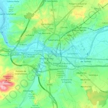
Name: Salamanca topographic map, elevation, terrain.
Location: Salamanca, Castile and León, Spain (40.91463 -5.73580 40.99319 -5.62262)
Average elevation: 812 m
Minimum elevation: 763 m
Maximum elevation: 935 m
Other topographic maps
Click on a map to view its topography, its elevation and its terrain.
Yacimiento arqueológico La Edrada
Spain > Castile and León > El Bierzo > Cacabelos
Average elevation: 493 m
Poblado del Salto de Aldeadávila
Spain > Castile and León > Aldeadávila de la Ribera
Average elevation: 535 m
Castrillo Mota de Judíos
Spain > Castile and León > Castrillo Mota de Judíos > Castrillo Mota de Judíos
Average elevation: 801 m