Geolocate

Perak topographic map

Click on the map to display elevation.

Perak

In 1959, a British artillery officer stationed at an inland army base during the Malayan Emergency discovered the Tambun rock art, identified by archaeologists as the largest rock art site in the Malay Peninsula. Most of the paintings are located high above the cave floor, at an elevation of 6–10 metres (20–33 ft). Seashells and coral fragments scattered along the cave floor are evidence that the area was once underwater.

Wikipedia (CC-BY-SA 3.0)

About this map

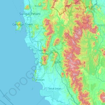
Name: Perak topographic map, elevation, terrain.

Location: Perak, Malaysia (3.66754 100.36129 5.93439 101.75333)

Average elevation: 251 m

Minimum elevation: -1 m

Maximum elevation: 2,127 m

Other topographic maps

Click on a map to view its topography, its elevation and its terrain.

Johor Bahru

Malaysia > Johor

Average elevation: 23 m

Kuala Lumpur

Malaysia > Kuala Lumpur

Located in the centre of Selangor state, Kuala Lumpur was a territory of Selangor State Government. In 1974, Kuala Lumpur was split off from Selangor to form the first Federal Territory governed directly by the Malaysian federal government. Its location in the most developed state on the west coast of…

Average elevation: 127 m

Ipoh

Malaysia > Perak > Majlis Bandaraya Ipoh

Average elevation: 205 m

Jenjarom

Malaysia > Selangor

Average elevation: 4 m

Seri Iskandar

Malaysia > Perak

Seri Iskandar (Jawi: سري إسكندر, Chinese: 斯里依斯干达) is a major town within the Perak Tengah District in the state of Perak, Malaysia. It is situated about 40 kilometers southwest of the city of Ipoh, the state capital. The town is at an average elevation of 29 meters above the sea level. The…

Average elevation: 29 m

Kuching

Malaysia > Sarawak > Kuching

Average elevation: 17 m

Taiping

Malaysia > Perak

Average elevation: 193 m

Kota Kinabalu

Malaysia > Sabah

Average elevation: 86 m

Seremban

Malaysia > Negeri Sembilan

Average elevation: 168 m

Penang Island

Malaysia > Penang Island

Penang Island is irregularly shaped, with a hilly and mostly forested interior; its coastal plains are narrow, the most extensive of which is at the northeastern cape. With a height of 833 m (2,733 ft), Penang Hill, at the centre of the island, is the tallest point within Penang. From a small settlement at the…

Average elevation: 117 m

FELDA Soeharto

Malaysia > Selangor

Average elevation: 43 m

Puncak Alam

Malaysia > Selangor > Puncak Alam

Average elevation: 30 m

Ayer Keroh

Malaysia > Malacca

Average elevation: 21 m

Cameron Highlands

Malaysia > Pahang

Surveyed by the government geologist and explorer William Cameron in 1885, the outpost consists of three mukims (subdistricts), namely Ringlet, Tanah Rata and Ulu Telom. Its eight settlements are Ringlet, Tanah Rata (the administrative centre), Brinchang, the Bertam Valley, Kea Farm, Tringkap, Kampung Kuala…

Average elevation: 1,400 m

Kuala Kedah

Malaysia > Kedah

Average elevation: 2 m

Taman Botanikal Melaka

Malaysia > Malacca > Ayer Keroh

Average elevation: 38 m

Klang

Malaysia > Selangor > Klang

Average elevation: 13 m

Kuala Terengganu

Malaysia > Terengganu > Kuala Terengganu

As a part of Terengganu, Kuala Terengganu has a tropical rainforest climate under the Köppen climate classification (Af) with constant temperature and high humidity. The amount of rainfall varies according to the monsoon season. It is generally fairly hot and humid all year round, averaging from 28 °C to 30…

Average elevation: 9 m

Jerantut

Malaysia > Pahang

Average elevation: 74 m

Port Dickson

Malaysia > Negeri Sembilan

Average elevation: 14 m

Subang Jaya

Malaysia > Selangor > Subang Jaya

Average elevation: 35 m

Sungai Kedah

Malaysia > Kedah > Kampung Pegawai

Average elevation: 4 m

Bukit Mertajam

Malaysia > Penang

Average elevation: 29 m

Sarawak River

Malaysia > Sarawak > Kuching

Average elevation: 6 m

Siburan

Malaysia > Sarawak > Kuching

Average elevation: 27 m

Lumut

Malaysia > Perak

Average elevation: 25 m

Sandakan

Malaysia > Sabah > Sandakan District

Average elevation: 6 m

Pahang

Malaysia > Pahang

The highest peak, Mount Tahan, reaches 2,187 m (7,175 ft) in elevation, which is also the highest point in the Peninsular Malaysia. The climate is temperate enough to have distinct temperature variations year round, and much of the highlands are covered with tropical rainforest. Pahang is home to Malaysia's…

Average elevation: 90 m

Teluk Cempedak

Malaysia > Pahang > Kuantan

Average elevation: 19 m

Sungai Pertang

Malaysia > Kelantan

Average elevation: 101 m

Kampung Telaga Air

Malaysia > Sarawak > Kuching

Average elevation: 3 m

Mount Chamah

Malaysia > Kelantan

Average elevation: 1,810 m

Kajang

Malaysia > Selangor > Kajang

Average elevation: 108 m

Semenyih

Malaysia > Selangor > Kajang Municipal Council

Average elevation: 62 m

Banting

Malaysia > Selangor > Banting > Banting

Average elevation: 5 m

Kuala Pilah

Malaysia > Negeri Sembilan

Average elevation: 123 m

Kangar

Malaysia > Perlis

Average elevation: 28 m

Kulai

Malaysia > Johor

Average elevation: 44 m

Bintulu

Malaysia > Sarawak > Bintulu

Average elevation: 18 m

Bandar Mas

Malaysia > Johor

Average elevation: 21 m

Pontian

Malaysia > Johor

Average elevation: 9 m

Segamat

Malaysia > Johor

Average elevation: 33 m

Balik Pulau

Malaysia > Penang > George Town

Average elevation: 136 m

Sungai Udang

Malaysia > Malacca

Average elevation: 30 m

Pantai Puteri

Malaysia > Malacca > Tanjung Kling

Average elevation: 5 m

Mawai

Malaysia > Johor

Average elevation: 16 m

Dataran Nilai

Malaysia > Negeri Sembilan > Nilai

Average elevation: 58 m

Merbok

Malaysia > Kedah

Average elevation: 130 m

Kampung Sungai Mekong

Malaysia > Kelantan

Average elevation: 142 m

Bukit Gambir

Malaysia > Johor

Average elevation: 8 m

Gunung Datuk

Malaysia > Negeri Sembilan

The main highlight of the mountain is a tor that consists of massive granite boulders, at the elevation of 855 m (2,805 ft).

Average elevation: 450 m

Renggam

Malaysia > Johor

Average elevation: 61 m

Pekan

Malaysia > Pahang

Average elevation: 8 m

Keningau

Malaysia > Sabah > Keningau

Average elevation: 520 m

Temerloh

Malaysia > Pahang

Average elevation: 48 m

Sungkai

Malaysia > Perak

Average elevation: 47 m

Pasir Gudang

Malaysia > Johor

Average elevation: 21 m

Alor Setar

Malaysia > Kedah

Average elevation: 9 m

Batu Pahat

Malaysia > Johor

Average elevation: 10 m

Puchong

Malaysia > Selangor > Subang Jaya City Council

Average elevation: 38 m

Kuantan

Malaysia > Pahang

Average elevation: 14 m

Cyberjaya

Malaysia > Selangor > Cyberjaya

Average elevation: 24 m

Miri

Malaysia > Sarawak > Miri

Average elevation: 9 m

Teluk Intan

Malaysia > Perak

Average elevation: 6 m

Bau

Malaysia > Sarawak > Bau

Average elevation: 49 m

Sibu

Malaysia > Sarawak > Sibu

Sibu is located near the Rajang delta at the confluence of Rajang and Igan rivers. Peat swamp forests and alluvial plains are particularly prevalent in the Sibu Division. Sibu is located on a deep peat soil, which has caused problems in infrastructure development because buildings and roads slowly sink into…

Average elevation: 10 m

Sungai Petani

Malaysia > Kedah

Average elevation: 45 m

Genting Highlands

Malaysia > Pahang

Genting Highlands is a hill station and a city located on the peak of Mount Ulu Kali in the Titiwangsa Mountains, central Peninsular Malaysia, at 1800 metres elevation. It is the second seat of Bentong District after Bentong. Located in the state of Pahang. It was established in 1965 by the late Malaysian…

Average elevation: 1,141 m

Kota Tinggi

Malaysia > Johor

Average elevation: 17 m

Kampar

Malaysia > Perak

Average elevation: 240 m

Genting Highlands

Malaysia > Pahang

Genting Highlands is a hill station located on the peak of Mount Ulu Kali in the Titiwangsa Mountains, central Peninsular Malaysia, at 1800 metres elevation. Located in the state of Pahang, it was established in 1965 by the late Malaysian businessman Lim Goh Tong. The primary tourist attraction is Resorts…

Average elevation: 1,141 m

Gua Musang

Malaysia > Kelantan

Average elevation: 144 m

Gerik

Malaysia > Perak > Gerik

Average elevation: 163 m

Titiwangsa Lake Garden

Malaysia > Kuala Lumpur

Average elevation: 42 m

Pensiangan

Malaysia > Sabah > Nabawan

Average elevation: 272 m

Kampung Seri Perkasa

Malaysia > Perak

Average elevation: 4 m

Kampung Simpang Makmur

Malaysia > Perak > Taiping

Average elevation: 11 m

Gemas

Malaysia > Negeri Sembilan

Average elevation: 42 m

Rundum Highland

Malaysia > Sabah > Tenom

Average elevation: 1,110 m

Kampung Marhum

Malaysia > Pahang

Average elevation: 4 m

Johor Bahru

Malaysia > Johor

Average elevation: 23 m

Kepong

Malaysia > Kuala Lumpur

Average elevation: 113 m

Tanah Rata

Malaysia > Pahang

Tanah Rata is a town located in Cameron Highlands, Pahang, Malaysia. The name "tanah rata" means flat ground in Malay and it refers to the relatively flat area on which the town is located amidst this highland region. It has an elevation of 1,440 metres (4,720 ft).

Average elevation: 1,393 m

Mount Kinabalu

Malaysia > Sabah > Ranau

Mount Kinabalu (Malay: Gunung Kinabalu, Dusun: Gayo Ngaran or Nulu Nabalu) is the highest mountain in Borneo and Malaysia. With an elevation of 13,435 feet (4,095 m), it is third-highest peak of an island on Earth, and 20th most prominent mountain in the world by topographic prominence. The mountain is located…

Average elevation: 3,567 m

Bukit Simbang

Malaysia > Johor

Average elevation: 116 m

Bukit Jengeli East

Malaysia > Johor

Average elevation: 234 m

Bukit Kerinting

Malaysia > Johor > Kampung Panca Jaya

Average elevation: 64 m

Kampung Rapak

Malaysia > Sabah > Ranau > Togudon Baru

Average elevation: 546 m

Kampung Bendang Raja

Malaysia > Kedah

Average elevation: 18 m

Kampung Bakau Tua

Malaysia > Penang

Average elevation: 3 m

Sungai Bekok

Malaysia > Johor

Average elevation: 77 m

Kuala Tahan

Malaysia > Pahang

Average elevation: 131 m

RPR Matang Sungai Tengah 2

Malaysia > Sarawak > Kuching

Average elevation: 18 m

Kampung Behrang Ulu

Malaysia > Perak

Average elevation: 55 m

Gear up for your next adventure:

🥾Men's Waterproof Hiking Boots - Durable footwear with deep lugs for muddy and rocky UK terrains
🧦Merino Wool Hiking Socks - Moisture-wicking socks to prevent blisters during long mountain walks
🥾Hiking Boots - Waterproof and durable boots for long-distance hiking in the UK
Insulated Travel Mugs - Keep drinks hot while surveying the landscape from a summit
🧤Hiking Gloves - Warm and durable gloves for cold-weather walks

As an Amazon Associate, this site earns from qualifying purchases at no extra cost to you.