
Elko County topographic map
Interactive map
Click on the map to display elevation.
Elko County
According to the U.S. Census Bureau, the county has a total area of 17,203 square miles (44,560 km2), of which 17,170 square miles (44,500 km2) is land and 33 square miles (85 km2) (0.2%) is water.[6] Not counting Alaska's boroughs (four of which are also larger), it is the fourth-largest county in area in the United States (behind San Bernardino County, California, Coconino County, Arizona, and Nye County, Nevada).[7] The elevation ranges from about 4,300 feet (1,300 m) at the edge of the salt flats of the Great Salt Lake Desert, to 11,387 feet (3,471 m) on the summit of Ruby Dome in the Ruby Mountains.[8] The most topographically prominent mountain in Elko County is Pilot Peak.
About this map
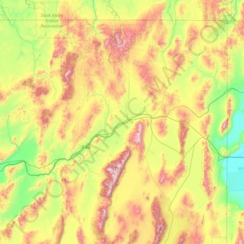
Name: Elko County topographic map, elevation, terrain.
Location: Elko County, Nevada, United States (40.11857 -117.01775 41.99921 -114.04030)
Average elevation: 1,838 m
Minimum elevation: 1,282 m
Maximum elevation: 3,337 m
Other topographic maps
Click on a map to view its topography, its elevation and its terrain.
Jackpot
United States > Nevada > Elko County
In addition to its casino industry, Jackpot has its own schools, golf course, and post office. Its elevation is approximately 5,200 feet (1,580 m) above sea level.
Average elevation: 1,635 m
Hiko
United States > Nevada > Lincoln County
The Hiko and Crystal Springs provide a large supply of water for the Hiko farms and ranches. The Hiko farming community is located in the north end of the Pahranagat Valley and lies at an elevation of 3,869 feet (1,179 m), with a ZIP code of 89017.
Average elevation: 1,233 m
McDermitt
United States > Nevada > Humboldt County
The community is on U.S. Highway 95, 73 miles (117 km) north of Winnemucca. The elevation of McDermitt is 4,432 feet (1,351 m) above sea level.
Average elevation: 1,359 m
Austin
United States > Nevada > Lander County
Austin is an unincorporated small town in, and former county seat of, Lander County, Nevada, United States. In 2020, the census-designated place of Austin had a population of 167. It is located on the western slopes of the Toiyabe Range at an elevation of 6,575 feet (2,004 m). U.S. Route 50 passes through the…
Average elevation: 2,076 m
Great Basin
United States > Nevada > Eureka County
The Great Basin is the largest area of contiguous endorheic watersheds, those with no outlets, in North America. It spans nearly all of Nevada, much of Utah, and portions of California, Idaho, Oregon, Wyoming, and Baja California. It is noted for both its arid climate and the basin and range topography that…
Average elevation: 1,918 m
Mercury
United States > Nevada > Nye County
In 1957, the US Navy launched nine atmospheric sounding rockets to measure nuclear radiation and other atmospheric data, using Mercury as a staging area. The Naval Radiological Defense Laboratory conducted its first test flight in 1956. This test rocket lifted 13.6 kilograms (30 lb) to an altitude of 40…
Average elevation: 1,183 m
Walker Lake
United States > Nevada > Mineral County > Schurz
These diversions have resulted in a severe drop in the lake's level. According to the USGS, the level dropped approximately 181 ft (55 m) between 1882 and 2016. By June 2016, the lake level was 3,909 feet (1,191 m) above sea level, the lowest lake elevation since measurement began in 1882. As of 2022, Walker…
Average elevation: 1,531 m
Oxbow Nature Study Area
United States > Nevada > Washoe County > Reno > West Reno
Average elevation: 1,415 m
Winnemucca
United States > Nevada > Humboldt County > Winnemucca > Winnemucca
Average elevation: 1,403 m