
Sint Eustatius topographic map
Interactive map
Click on the map to display elevation.
About this map
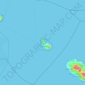
Name: Sint Eustatius topographic map, elevation, terrain.
Location: Sint Eustatius, Netherlands (17.27673 -63.19861 17.72699 -62.78471)
Average elevation: 12 m
Minimum elevation: 0 m
Maximum elevation: 1,044 m
Sint Eustatius is 6 miles (10 km) long and up to 3 miles (5 km) wide. Topographically, the island is saddle-shaped, with the 602-meter-high dormant volcano Quill (Mount Mazinga), (from Dutch kuil, meaning 'pit'—originally referring to its crater) to the southeast and the smaller summits of Signal Hill/Little Mountain (or Bergje) and Boven Mountain to the northwest. The Quill crater is a popular tourist attraction on the island. The bulk of the island's population lives in the flat saddle between the two elevated areas, which forms the centre of the island.
Other topographic maps
Click on a map to view its topography, its elevation and its terrain.
Haarlem
Netherlands > North Holland > Haarlem
Haarlem, North Holland, Netherlands
Average elevation: 3 m
Zevenbergen
Zevenbergen, Moerdijk, North Brabant, Netherlands
Average elevation: 1 m
Noordwijkerhout
Netherlands > South Holland > Noordwijk
Noordwijkerhout, Noordwijk, South Holland, Netherlands
Average elevation: 2 m
Helle
Netherlands > Limburg > Mechelen
Helle, Mechelen, Gulpen-Wittem, Limburg, Netherlands, 6281 BS, Netherlands
Average elevation: 158 m
Onstwedde
Onstwedde, Stadskanaal, Groningen, Netherlands
Average elevation: 4 m
Braassemermeer
Netherlands > South Holland > Rijnsaterwoude
Braassemermeer, Rijnsaterwoude, Kaag en Braassem, South Holland, Netherlands
Average elevation: -2 m
Ginderdoor
Netherlands > North Brabant > Chaam
Ginderdoor, Chaam, Alphen-Chaam, North Brabant, Netherlands, 4861 CG, Netherlands
Average elevation: 11 m
Kinderdijk
Kinderdijk, Molenlanden, South Holland, Netherlands
Average elevation: 1 m
Meijendel
Netherlands > South Holland > Wassenaar
Meijendel, Wassenaar, South Holland, Netherlands, 2244 AG, Netherlands
Average elevation: 6 m
Helvoirt
Helvoirt, Vught, North Brabant, Netherlands
Average elevation: 7 m
Heesakker
Netherlands > North Brabant > Haaren
Heesakker, Haaren, Oisterwijk, North Brabant, Netherlands, 5076 PR, Netherlands
Average elevation: 7 m
De Moer
De Moer, Loon op Zand, North Brabant, Netherlands
Average elevation: 7 m
Friese Buurt
Netherlands > North Holland > Den Helder
Friese Buurt, Den Helder, North Holland, Netherlands, 1786 PL, Netherlands
Average elevation: 0 m
Berlicum
Berlicum, Sint-Michielsgestel, North Brabant, Netherlands
Average elevation: 6 m
Oppenhuizen
Oppenhuizen, Súdwest-Fryslân, Frisia, Netherlands
Average elevation: 0 m
Westernieland
Westernieland, Het Hogeland, Groningen, Netherlands
Average elevation: 0 m
Valkeveen
Netherlands > North Holland > Naarden
Valkeveen, Naarden, Gooise Meren, North Holland, Netherlands, 1411 GT, Netherlands
Average elevation: 2 m
Wijk bij Duurstede
Netherlands > Utrecht > Wijk bij Duurstede
Wijk bij Duurstede, Utrecht, Netherlands
Average elevation: 5 m
Abbenes
Abbenes, Haarlemmermeer, North Holland, Netherlands
Average elevation: -4 m
Berenbroek
Netherlands > North Brabant > Helmond
Berenbroek, Helmond, North Brabant, Netherlands, 5707 DB, Netherlands
Average elevation: 19 m
Sint-Oedenrode
Sint-Oedenrode, Meierijstad, North Brabant, Netherlands
Average elevation: 12 m
Vierhuizen
Netherlands > Frisia > Allingawier
Vierhuizen, Allingawier, Súdwest-Fryslân, Frisia, Netherlands, 8758 LG, Netherlands
Average elevation: -2 m
Luchtpark Hofbogen
Netherlands > South Holland > Rotterdam
Luchtpark Hofbogen, Agniesebuurt, Noord, Rotterdam, South Holland, Netherlands, 3032 AH, Netherlands
Average elevation: 4 m
Slootdorp
Slootdorp, Hollands Kroon, North Holland, Netherlands
Average elevation: -2 m
Rozenburg
Rozenburg, Haarlemmermeer, North Holland, Netherlands
Average elevation: -3 m