Geolocate

Gear up for your next adventure:

As an Amazon Associate, this site earns from qualifying purchases at no extra cost to you.

👉 Easily get elevation data in JSON, GeoTIFF and KML formats using Elevation API
Thank you for supporting this site ❤️
Make a donation

Ontario topographic map

Click on the map to display elevation.

Gear up for your next adventure:

As an Amazon Associate, this site earns from qualifying purchases at no extra cost to you.

Gear up for your next adventure:

As an Amazon Associate, this site earns from qualifying purchases at no extra cost to you.

👉 Easily get elevation data in JSON, GeoTIFF and KML formats using Elevation API
Thank you for supporting this site ❤️
Make a donation

Ontario

Ontario's topography is a diverse tapestry shaped by its vast expanse and geological history. The Canadian Shield dominates the northern and central regions, characterized by ancient Precambrian rock formations, rugged terrain, and numerous lakes and rivers. In contrast, the Hudson Bay Lowlands in the far north are flat, swampy areas with sparse vegetation. Southern Ontario features the fertile Great Lakes–St. Lawrence Lowlands, where rolling hills and plains support agriculture and urban development. Prominent features like the Niagara Escarpment add to the province's varied landscape, offering cliffs and slopes that contrast with the surrounding lowlands. The highest elevation point is Ishpatina Ridge in the Temagami area, reaching 693 meters (2,274 feet) above sea level. Overall, Ontario's terrain ranges from flat plains to rolling hills and rugged highlands, reflecting its complex geological past.

Gear up for your next adventure:

As an Amazon Associate, this site earns from qualifying purchases at no extra cost to you.

👉 Easily get elevation data in JSON, GeoTIFF and KML formats using Elevation API
Thank you for supporting this site ❤️
Make a donation

About this map

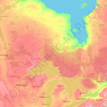
Name: Ontario topographic map, elevation, terrain.

Location: Ontario, Canada (41.67656 -95.15602 56.86135 -74.32011)

Average elevation: 245 m

Minimum elevation: -2 m

Maximum elevation: 996 m

Gear up for your next adventure:

As an Amazon Associate, this site earns from qualifying purchases at no extra cost to you.

👉 Easily get elevation data in JSON, GeoTIFF and KML formats using Elevation API
Thank you for supporting this site ❤️
Make a donation

Other topographic maps

Click on a map to view its topography, its elevation and its terrain.

Toronto

Canada > Ontario > Toronto

Despite its deep ravines, Toronto is not remarkably hilly, but its elevation does increase steadily away from the lake. Elevation differences range from 76.5 metres (251 ft) above sea level at the Lake Ontario shore to 209 m (686 ft) ASL near the York University grounds in the city's north end at the…

Average elevation: 113 m

Hamilton

Canada > Ontario > Hamilton

Average elevation: 181 m

Kingston

Canada > Ontario > Kingston

Average elevation: 94 m

Gear up for your next adventure:

As an Amazon Associate, this site earns from qualifying purchases at no extra cost to you.

Thank you for supporting this site ❤️
Make a donation

Grande Prairie

Canada > Alberta > Grande Prairie

Grande Prairie is located just north of the 55th parallel north, and is 465 km (289 mi) northwest of Edmonton, lying at an elevation of 669 m (2,195 ft) above sea level. The city is surrounded by farmland to the north, east, and west. To the south lies a vast boreal forest with aspen, tamarack, lodgepole pine,…

Average elevation: 668 m

Brantford

Canada > Ontario > Brantford

Average elevation: 238 m

London

Canada > Ontario > London > London

London has a humid continental climate (Köppen Dfb), though due to its downwind location relative to Lake Huron and elevation changes across the city, it is virtually on the Dfa/Dfb (hot summer) boundary favouring the former climate zone to the southwest of the confluence of the South and North Thames Rivers,…

Average elevation: 268 m

New Brunswick

Canada > New Brunswick

Average elevation: 165 m

Gear up for your next adventure:

As an Amazon Associate, this site earns from qualifying purchases at no extra cost to you.

Thank you for supporting this site ❤️
Make a donation

Red Deer

Canada > Alberta > Red Deer

Average elevation: 918 m

Coquitlam

Canada > British Columbia > Metro Vancouver Regional District > Coquitlam

Southwest Coquitlam comprises the original core of the city, with Maillardville and Fraser River industrial sector giving way to the large residential areas of Austin Heights, colloquially referred to as "The Bump" due to its high and flat plateau topography. These older residences, with larger property…

Average elevation: 230 m

Burnaby Mountain

Canada > British Columbia > Metro Vancouver Regional District > Burnaby

Due to its relatively high elevation, snow will often fall on the higher levels of Burnaby Mountain while rain falls in the surrounding cities. Tobogganing is a popular pastime at Centennial Park on winter days with snow.

Average elevation: 167 m

Maple Ridge

Canada > British Columbia > Maple Ridge

Average elevation: 193 m

Cambridge

Canada > Ontario > Cambridge

Average elevation: 295 m

Gear up for your next adventure:

As an Amazon Associate, this site earns from qualifying purchases at no extra cost to you.

Thank you for supporting this site ❤️
Make a donation

Brandon

Canada > Manitoba > Brandon

Average elevation: 393 m

Nestleton Station

Canada > Ontario > Durham Region > Scugog

Average elevation: 282 m

Gear up for your next adventure:

As an Amazon Associate, this site earns from qualifying purchases at no extra cost to you.

Thank you for supporting this site ❤️
Make a donation

Lethbridge

Canada > Alberta > Lethbridge

Its high elevation of 929 m (3,047.9 ft) and close proximity to the Rocky Mountains provides Lethbridge with cooler summers than other locations in the Canadian Prairies. These factors protect the city from strong northwest and southwest winds and contribute to frequent chinook winds during the winter.…

Average elevation: 918 m

Snag

Canada > Yukon

Average elevation: 553 m

Burnaby

Canada > British Columbia > Metro Vancouver Regional District > Burnaby

Burnaby occupies 98.60 square kilometres (38.07 sq mi) and is located at the geographic centre of the Metro Vancouver area and home to the Metro Vancouver regional government in Metrotown. Situated between the city of Vancouver on the west and Port Moody, Coquitlam, and New Westminster on the east, Burnaby is…

Average elevation: 144 m

Calgary

Canada > Alberta > Calgary

Average elevation: 1,106 m

Gear up for your next adventure:

As an Amazon Associate, this site earns from qualifying purchases at no extra cost to you.

Thank you for supporting this site ❤️
Make a donation

Canmore

Canada > Alberta > Town of Canmore

Elevation Place opened in April 2013 as Canmore's new recreation facility. Construction of the facility began in 2012 to replace the Canmore Recreation Centre (the community's old facility). The facility offers an 8-lane 25m lap pool, a world class climbing wall developed by Walltopia, two cardio rooms, a…

Average elevation: 1,565 m

Windsor

Canada > Ontario > Windsor

Average elevation: 185 m

Olds

Canada > Alberta > Town of Olds

Average elevation: 1,027 m

Colombourg

Canada > Quebec > Abitibi-Ouest

Average elevation: 291 m

Gear up for your next adventure:

As an Amazon Associate, this site earns from qualifying purchases at no extra cost to you.

Thank you for supporting this site ❤️
Make a donation

Lake Louise

Canada > Alberta > Improvement District No. 9

Lake Louise is a hamlet within Banff National Park in Alberta, Canada. Named after Princess Louise, Duchess of Argyll, it lies in Alberta's Rockies on the Bow River, 3 km (1.9 mi) northeast of the lake that shares its name. Initially settled in 1884 as an outpost for the Canadian Pacific Railway, Lake Louise…

Average elevation: 1,617 m

Gear up for your next adventure:

As an Amazon Associate, this site earns from qualifying purchases at no extra cost to you.

Thank you for supporting this site ❤️
Make a donation

Delaware

Canada > Ontario > Middlesex County > Middlesex Centre

Average elevation: 224 m

Otto Lake

Canada > Saskatchewan > Senlac No. 411

Average elevation: 623 m

Guelph

Canada > Ontario > Guelph

This region of Ontario has cold winters and warm, humid summers, falling into the Köppen climate classification Dfb zone, with moderately high rainfall and snowfall. It is generally a couple of degrees cooler than lower elevation regions on the Great Lakes shorelines, especially so in winter, the exception…

Average elevation: 344 m

Percy Boom

Canada > Ontario > Northumberland County > Trent Hills

Average elevation: 127 m

Gear up for your next adventure:

As an Amazon Associate, this site earns from qualifying purchases at no extra cost to you.

Thank you for supporting this site ❤️
Make a donation

Wooler

Canada > Ontario > Quinte West

Average elevation: 145 m

Peace River

Canada > Alberta > Peace River

Physiographically, the Town of Peace River lies within the Peace River Formation, a stratigraphical unit of middle Albian age in the Western Canadian Sedimentary Basin. The area developed on sediments of the former lake bottom of Glacial Lake Peace, which covered most of the areas in the region that were below…

Average elevation: 433 m

Gear up for your next adventure:

As an Amazon Associate, this site earns from qualifying purchases at no extra cost to you.

Thank you for supporting this site ❤️
Make a donation

Parry Sound

Canada > Ontario

Average elevation: 235 m

Cochrane

Canada > Alberta > Town of Cochrane > Cochrane

Cochrane is situated at the base of Big Hill in the Bow River Valley. It sits at an elevation of 1,186 m (3,891 ft). The town is intersected by Highway 1A and Highway 22. Cochrane has a reputation for its western culture, which can easily be felt when one wanders the streets (particularly Main Street). The…

Average elevation: 1,205 m

Mount Royal

Canada > Quebec > Urban agglomeration of Montreal > Montreal

The hill is part of the Monteregian Hills situated between the Laurentians and the Appalachian Mountains. It gave its Latin name, Mons Regius, to the Monteregian chain. The hill consists of three peaks: Colline de la Croix (or Mont Royal proper) at 233 m (764 ft), Colline d'Outremont (or Mount Murray, in the…

Average elevation: 111 m

Merritt

Canada > British Columbia > Merritt

Average elevation: 701 m

Gear up for your next adventure:

As an Amazon Associate, this site earns from qualifying purchases at no extra cost to you.

Thank you for supporting this site ❤️
Make a donation

Sheedy Lake

Canada > Ontario > Renfrew County > Bonnechere Valley

Average elevation: 367 m

Lac Crooks

Canada > Quebec > Argenteuil > Brownsburg-Chatham

Average elevation: 205 m

Gear up for your next adventure:

As an Amazon Associate, this site earns from qualifying purchases at no extra cost to you.

Thank you for supporting this site ❤️
Make a donation

Niagara Escarpment

Canada > Ontario > Hamilton

Average elevation: 162 m

Swastika

Canada > Ontario > Timiskaming District > Kirkland Lake

Average elevation: 318 m

Assiniboine River

Canada > Manitoba

Average elevation: 481 m

Gear up for your next adventure:

As an Amazon Associate, this site earns from qualifying purchases at no extra cost to you.

Thank you for supporting this site ❤️
Make a donation

Lake O'Hara

Canada > British Columbia > Columbia-Shuswap Regional District > Area A (Kicking Horse/Kinbasket Lake)

Lake O'Hara is a lake at an elevation of 2,020 metres (6,630 ft) in the alpine area of Yoho National Park, in the province of British Columbia, on the western side of the Great Divide with the province of Alberta and Banff National Park to the east. The lake and the valley are accessible through a bus service…

Average elevation: 2,276 m

Banff

Canada > Alberta > Banff > Banff

Banff is a town within Banff National Park in Alberta, Canada. It is located in Alberta's Rockies along the Trans-Canada Highway, approximately 126 km (78 mi) west of Calgary and 58 km (36 mi) east of Lake Louise. At 1,400 to 1,630 m (4,590 to 5,350 ft) above sea level, Banff is the community with the second…

Average elevation: 1,615 m

Peterborough

Canada > Ontario > Peterborough

Peterborough's topography is largely defined by land formations created by the receding Wisconsian glaciers 10,000–15,000 years ago. The South End and Downtown portions of the City sit on what was the bottom of the glacial Lake Peterborough—part of a glacial spillway created when glacial meltwaters from…

Average elevation: 235 m

Airdrie

Canada > Alberta > Airdrie

Average elevation: 1,112 m

Gear up for your next adventure:

As an Amazon Associate, this site earns from qualifying purchases at no extra cost to you.

Thank you for supporting this site ❤️
Make a donation

Minden Lake

Canada > Ontario > Haliburton County > Minden Hills > Minden

Average elevation: 321 m

Gear up for your next adventure:

As an Amazon Associate, this site earns from qualifying purchases at no extra cost to you.

Thank you for supporting this site ❤️
Make a donation

Nose Hill Park

Canada > Alberta > Calgary

Names currently associated with topographical features in and near Nose Hill Park reflect the impact of the European newcomers and European trade goods on the Peigan. For example, Spy Hill, the westward extension of Nose Hill, derived its present name from the aboriginal practice of communicating with distant…

Average elevation: 1,174 m

Niagara Escarpment

Canada > Ontario > Burlington

Average elevation: 216 m

Grouse Mountain

Canada > British Columbia > Metro Vancouver Regional District

Grouse Mountain is one of the North Shore Mountains of the Pacific Ranges in the District Municipality of North Vancouver, British Columbia, Canada. With a maximum elevation of over 1,200 m (4,100 feet) at its peak, the mountain is the site of an alpine ski area, Grouse Mountain Resort, which overlooks Greater…

Average elevation: 968 m

Riding Mountain National Park

Canada > Manitoba > Dauphin

The climate in the Riding Mountain region is similar to that of other regions of southwestern Manitoba. Under the Köppen classification it has a continental climate. It includes grasslands, upland boreal and eastern deciduous forest ecosystems. The park has hot summers and cold winters, with annual rainfall…

Average elevation: 488 m

Bragg Creek

Canada > Alberta

Average elevation: 1,384 m

Gear up for your next adventure:

As an Amazon Associate, this site earns from qualifying purchases at no extra cost to you.

Thank you for supporting this site ❤️
Make a donation

Okotoks

Canada > Alberta > Town of Okotoks

Average elevation: 1,096 m

Wooler

Canada > Ontario > Quinte West

Average elevation: 145 m

Pied-du-Lac

Canada > Quebec > Témiscouata

Average elevation: 267 m

Saint-Coeur-de-Marie

Canada > Quebec > Lac-Saint-Jean-Est > Alma

Average elevation: 110 m

Niagara Escarpment

Canada > Ontario > Hamilton

Average elevation: 148 m

Gear up for your next adventure:

As an Amazon Associate, this site earns from qualifying purchases at no extra cost to you.

Thank you for supporting this site ❤️
Make a donation

Nanaimo

Canada > British Columbia > Nanaimo

Average elevation: 142 m

Gear up for your next adventure:

As an Amazon Associate, this site earns from qualifying purchases at no extra cost to you.

Thank you for supporting this site ❤️
Make a donation

Haliburton

Canada > Ontario

Average elevation: 358 m

Dundas

Canada > Ontario > Hamilton > Dundas

Dundas /ˈdʌnˌdæs/ is a community and former town in Hamilton, Ontario, Canada. It is nicknamed the Valley Town because of its topographical location at the bottom of the Niagara Escarpment on the western edge of Lake Ontario. The population has been stable for decades at about twenty thousand, largely…

Average elevation: 171 m

Gear up for your next adventure:

As an Amazon Associate, this site earns from qualifying purchases at no extra cost to you.

Thank you for supporting this site ❤️
Make a donation

Crowsnest Pass

Canada > Alberta > Crowsnest Pass

Average elevation: 1,410 m

Okotoks

Canada > Alberta > Town of Okotoks

Average elevation: 1,096 m

St. Albert

Canada > Alberta > St. Albert

Average elevation: 681 m

Gear up for your next adventure:

As an Amazon Associate, this site earns from qualifying purchases at no extra cost to you.

Thank you for supporting this site ❤️
Make a donation

Colton Lake

Canada > Ontario > Renfrew County

Average elevation: 184 m

Gear up for your next adventure:

As an Amazon Associate, this site earns from qualifying purchases at no extra cost to you.

Thank you for supporting this site ❤️
Make a donation