
Make a donation
Gear up for your next adventure:
As an Amazon Associate, this site earns from qualifying purchases at no extra cost to you.
Laurentian Mountains topographic map
Click on the map to display elevation.
Make a donation
Gear up for your next adventure:
As an Amazon Associate, this site earns from qualifying purchases at no extra cost to you.
Laurentian Mountains
One of Quebec's official regions is called Laurentides. The mountain range runs through four other regions; Capitale-Nationale, Outaouais, Lanaudière, and Mauricie. The elevation generally ranges from around 500 m (1,640 ft) to 1,000 m (3,280 ft) with Mont Raoul-Blanchard being its highest peak, at 1,166 m (3,825 ft). Mont Tremblant, Mont Bleu, and Mont des Conscrits are other prominent peaks in the mountain range. Jacques-Cartier National Park is located in this mountain range, which is north of Quebec City, residing in the Jacques-Cartier Massif. The Adirondack Mountains, which are located in northeastern New York, have great similarity to the Laurentian Mountains, consisting of the same type of rocks that are part of the Canadian Shield.
Make a donation
Gear up for your next adventure:
As an Amazon Associate, this site earns from qualifying purchases at no extra cost to you.
About this map
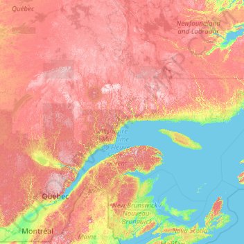
Name: Laurentian Mountains topographic map, elevation, terrain.
Location: Laurentian Mountains, Canada (46.50177 -74.39339 53.69136 -58.57365)
Average elevation: 348 m
Minimum elevation: -2 m
Maximum elevation: 1,302 m
Make a donation
Gear up for your next adventure:
As an Amazon Associate, this site earns from qualifying purchases at no extra cost to you.
Other topographic maps
Click on a map to view its topography, its elevation and its terrain.
Make a donation
Gear up for your next adventure:
As an Amazon Associate, this site earns from qualifying purchases at no extra cost to you.
St. Joseph Island
Canada > Ontario > Algoma District > Jocelyn Township
Its highest point, known colloquially and by surveyors as "the Mountain," is near the centre of the island near Carterton with an elevation of 345.6 m, which is about 169 m above Lake Huron.
Average elevation: 196 m
Make a donation
Gear up for your next adventure:
As an Amazon Associate, this site earns from qualifying purchases at no extra cost to you.
Toronto
Despite its deep ravines, Toronto is not remarkably hilly, but its elevation does increase steadily away from the lake. Elevation differences range from 76.5 metres (251 ft) above sea level at the Lake Ontario shore to 209 m (686 ft) ASL near the York University grounds in the city's north end at the…
Average elevation: 113 m
Devon Island
Because of its relatively high elevation and its extreme northern latitude, it supports only a meagre population of muskox and small birds and mammals; the island does support hypolith communities. Animal life is concentrated in the Truelove Lowland area of the island, which has a favourable microclimate and…
Average elevation: 156 m
Make a donation
Gear up for your next adventure:
As an Amazon Associate, this site earns from qualifying purchases at no extra cost to you.
Lake Ontario
Lake Ontario is the easternmost of the Great Lakes and the smallest in surface area (7,340 sq mi, 18,960 km2), although it exceeds Lake Erie in volume (393 cu mi, 1,639 km3). It is the 13th largest lake in the world. When its islands are included, the lake's shoreline is 712 miles (1,146 km) long. As the last…
Average elevation: 214 m
Richmond
Canada > British Columbia > Metro Vancouver Regional District > Richmond
Average elevation: 15 m
Make a donation
Gear up for your next adventure:
As an Amazon Associate, this site earns from qualifying purchases at no extra cost to you.
Abraham Lake
Canada > Alberta > Census Division No. 9
The Government of Alberta sponsored a contest to name the lake in February 1972, during the final stages of construction of the Bighorn Dam. Students across the province were asked to submit names taking into consideration "historical significance, prominent persons, geography and topography, and the value of…
Average elevation: 1,886 m
Whitehorse
Whitehorse has a subarctic climate (Köppen climate classification: Dfc) and lies in the rain shadow of the Coast Mountains, causing precipitation totals to be quite low year-round. Due to the city's location in the Whitehorse valley, the climate is milder than other comparable northern communities such as…
Average elevation: 1,008 m
Make a donation
Gear up for your next adventure:
As an Amazon Associate, this site earns from qualifying purchases at no extra cost to you.
Make a donation
Gear up for your next adventure:
As an Amazon Associate, this site earns from qualifying purchases at no extra cost to you.
Lady Evelyn Lake
Canada > Ontario > Timiskaming District > Unorganized West Timiskaming
Average elevation: 318 m
Make a donation
Gear up for your next adventure:
As an Amazon Associate, this site earns from qualifying purchases at no extra cost to you.
Abbotsford
Canada > British Columbia > Fraser Valley Regional District > Abbotsford
Average elevation: 115 m
Iqaluit
Iqaluit has a tundra climate (Köppen: ET) typical of the Arctic region, although it is well outside the Arctic Circle. The city features long, cold winters and brief, cool summers. Average monthly temperatures are below freezing for eight months of the year. Iqaluit averages just over 400 mm (16 in) of…
Average elevation: 50 m
Mary's Peak
Canada > British Columbia > Capital Regional District > Juan de Fuca Electoral Area
Average elevation: 458 m
Make a donation
Gear up for your next adventure:
As an Amazon Associate, this site earns from qualifying purchases at no extra cost to you.
Make a donation
Gear up for your next adventure:
As an Amazon Associate, this site earns from qualifying purchases at no extra cost to you.
Round Lake
Canada > Ontario > Killaloe, Hagarty and Richards > Round Lake Centre
Average elevation: 178 m
Make a donation
Gear up for your next adventure:
As an Amazon Associate, this site earns from qualifying purchases at no extra cost to you.
Make a donation
Gear up for your next adventure:
As an Amazon Associate, this site earns from qualifying purchases at no extra cost to you.
Banff
Canada > Alberta > Banff > Banff
Banff is a town within Banff National Park in Alberta, Canada. It is located in Alberta's Rockies along the Trans-Canada Highway, approximately 126 km (78 mi) west of Calgary and 58 km (36 mi) east of Lake Louise. At 1,400 to 1,630 m (4,590 to 5,350 ft) above sea level, Banff is the community with the second…
Average elevation: 1,615 m
Halfmoon Bay
Canada > British Columbia > Sunshine Coast Regional District > Area B (Halfmoon Bay) > Halfmoon Bay
Average elevation: 16 m
Make a donation
Gear up for your next adventure:
As an Amazon Associate, this site earns from qualifying purchases at no extra cost to you.
Calabogie Lake
Canada > Ontario > Renfrew County > Greater Madawaska > Calabogie
Average elevation: 181 m
Make a donation
Gear up for your next adventure:
As an Amazon Associate, this site earns from qualifying purchases at no extra cost to you.
Make a donation
Gear up for your next adventure:
As an Amazon Associate, this site earns from qualifying purchases at no extra cost to you.
Qualicum Beach
Canada > British Columbia > Regional District of Nanaimo > Qualicum Beach > Qualicum Beach
Average elevation: 47 m
Make a donation
Gear up for your next adventure:
As an Amazon Associate, this site earns from qualifying purchases at no extra cost to you.
Nemaiah Valley
Canada > British Columbia > Cariboo Regional District > Area J (West Chilcotin)
Average elevation: 1,270 m
Make a donation
Gear up for your next adventure:
As an Amazon Associate, this site earns from qualifying purchases at no extra cost to you.
Sinclair Mills
Canada > British Columbia > Regional District of Fraser-Fort George > Area F (Willow River/Upper Fraser)
Average elevation: 659 m
Make a donation
Gear up for your next adventure:
As an Amazon Associate, this site earns from qualifying purchases at no extra cost to you.
Howe Sound
Canada > British Columbia > Sunshine Coast Regional District > Area F (West Howe Sound)
Average elevation: 529 m
Make a donation
Gear up for your next adventure:
As an Amazon Associate, this site earns from qualifying purchases at no extra cost to you.
Banff National Park
Canada > Alberta > Division No. 15
Banff National Park has a subarctic climate with three ecoregions, including montane, subalpine, and alpine. The forests are dominated by Lodgepole pine at lower elevations and Engelmann spruce in higher ones below the treeline, above which is primarily rocks and ice. Mammal species such as the grizzly bear,…
Average elevation: 1,848 m
Make a donation
Gear up for your next adventure:
As an Amazon Associate, this site earns from qualifying purchases at no extra cost to you.
Powder King Peak
Canada > British Columbia > Regional District of Fraser-Fort George > Area G (Crooked River/Parsnip)
Average elevation: 1,381 m
Souris
Canada > Manitoba > Division No. 7 > Municipality of Souris – Glenwood
Average elevation: 433 m
Make a donation
Gear up for your next adventure:
As an Amazon Associate, this site earns from qualifying purchases at no extra cost to you.
Seton Lake
Canada > British Columbia > Squamish-Lillooet Regional District > Area B (Cayoosh/Pavilion)
The lake is bounded by snow-capped mountains that descend abruptly to the shores. Environmental conditions largely mirror the Anderson Lake geology, topography, and climate. However, glacial silt from Cayoosh Creek, entering via the power station tunnel, makes the lake water much cloudier than Anderson.
Average elevation: 1,339 m
Make a donation
Gear up for your next adventure:
As an Amazon Associate, this site earns from qualifying purchases at no extra cost to you.
Fredericton
Canada > New Brunswick > Kingsclear Parish > Island View
At an altitude of about 17 m (56 ft) above sea level, Fredericton is nestled in the Pennsylvanian Basin. It differs markedly from the geologically older parts of the province. There are prominently two distinct areas in the region that are divided around the area of Wilsey Road, in the east end of the city. In…
Average elevation: 70 m
Peterborough
Canada > Ontario > Peterborough
Peterborough's topography is largely defined by land formations created by the receding Wisconsian glaciers 10,000–15,000 years ago. The South End and Downtown portions of the City sit on what was the bottom of the glacial Lake Peterborough—part of a glacial spillway created when glacial meltwaters from…
Average elevation: 235 m
Make a donation
Gear up for your next adventure:
As an Amazon Associate, this site earns from qualifying purchases at no extra cost to you.
Yoho National Park
Canada > British Columbia > Columbia-Shuswap Regional District
The weather in the park is localized and changeable. Located on the western side of the continental divide, it receives more precipitation than areas east of the divide. Precipitation in the park increases with elevation. In winter, average temperatures are between 5 and −15 °C (41.0 and 5.0 °F) from the…
Average elevation: 1,934 m
Make a donation
Gear up for your next adventure:
As an Amazon Associate, this site earns from qualifying purchases at no extra cost to you.
Mount Wrottesley
Canada > British Columbia > Sunshine Coast Regional District > Area F (West Howe Sound)
Average elevation: 1,076 m
Whistler
Canada > British Columbia > Squamish-Lillooet Regional District > Whistler Resort Municipality > Whistler
Average elevation: 996 m
Make a donation
Gear up for your next adventure:
As an Amazon Associate, this site earns from qualifying purchases at no extra cost to you.
Make a donation
Gear up for your next adventure:
As an Amazon Associate, this site earns from qualifying purchases at no extra cost to you.