
Cisneros topographic map
Interactive map
Click on the map to display elevation.
About this map
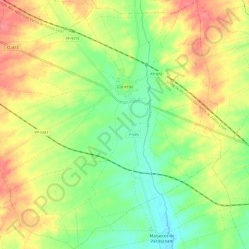
Name: Cisneros topographic map, elevation, terrain.
Location: Cisneros, Palencia, Castile and León, 34320, Spain (42.16425 -4.92641 42.25107 -4.81231)
Average elevation: 805 m
Minimum elevation: 774 m
Maximum elevation: 839 m
Other topographic maps
Click on a map to view its topography, its elevation and its terrain.
Yacimiento arqueológico La Edrada
Spain > Castile and León > El Bierzo > Cacabelos
Average elevation: 493 m
Poblado del Salto de Aldeadávila
Spain > Castile and León > Aldeadávila de la Ribera
Average elevation: 535 m
Castrillo Mota de Judíos
Spain > Castile and León > Castrillo Mota de Judíos > Castrillo Mota de Judíos
Average elevation: 801 m