
Gijón topographic map
Interactive map
Click on the map to display elevation.
Gijón
The city is situated on the coast of central Asturias, from sea level to an altitude of 513 m (1,683 ft) at Picu Samartín and 672 m (2,205 ft) at Peña de los Cuatro Jueces, bordered on the West by Carreño, the East by Villaviciosa, and to the South by Siero and Llanera.
About this map
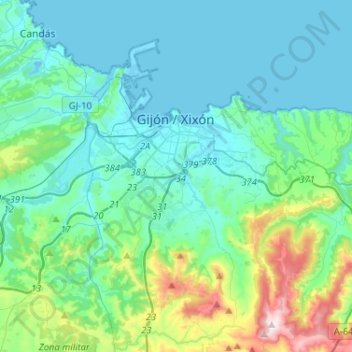
Name: Gijón topographic map, elevation, terrain.
Location: Gijón, Asturias, Spain (43.44151 -5.82132 43.58677 -5.56312)
Average elevation: 128 m
Minimum elevation: -8 m
Maximum elevation: 730 m
Other topographic maps
Click on a map to view its topography, its elevation and its terrain.
Picos de Europa
The Picos de Europa ("Peaks of Europe", also the Picos) are a mountain range extending for about 20 km (12 mi), forming part of the Cantabrian Mountains in northern Spain. The range is situated in the Autonomous Communities of Asturias, Cantabria and Castile and León. The highest peak is Torre de Cerredo, at…
Average elevation: 2,290 m