
Dhaka Division topographic map
Click on the map to display elevation.
About this map
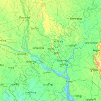
Name: Dhaka Division topographic map, elevation, terrain.
Location: Dhaka Division, Bangladesh (22.84565 89.30123 24.78869 91.24878)
Average elevation: 9 m
Minimum elevation: -3 m
Maximum elevation: 52 m
Other topographic maps
Click on a map to view its topography, its elevation and its terrain.
Dhaka
Bangladesh > Dhaka Division > Dhaka Metropolitan
In 2013, suburban services to Narayanganj and Gazipur cities were upgraded using diesel electric multiple unit trains. The Dhaka Metro Rail feasibility study has been completed. A 20.1-kilometre (12.5 mi), $2.8-billion Phase 1 metro route is being negotiated by the Government with Japan International…
Average elevation: 7 m
Cox's Bazar
Bangladesh > Chattogram Division
Cox's Bazar lies on a coastal plain in the southeastern corner of Bangladesh. From above, the plain appears to bulge out into the Bay of Bengal. Along the shore is an extensive area of beach and dunes. Most of the city is built on a floodplain that is lower in elevation than the dunes, making it more…
Average elevation: 8 m
Chattogram
Bangladesh > Chattogram Division > Chattogram
Chittagong lies at 22°22′0″N 91°48′0″E / 22.36667°N 91.80000°E / 22.36667; 91.80000. It straddles the coastal foothills of the Chittagong Hill Tracts in southeastern Bangladesh. The Karnaphuli River runs along the southern banks of the city, including its central business district. The…
Average elevation: 6 m
Bashundhara Community Park
Bangladesh > Dhaka Division > Dhaka Metropolitan > Panchkhola
Average elevation: 4 m
Tangail
Bangladesh > Dhaka Division > Tangail Sadar Upazila
The city of Tangail is in Dhaka Division, Central Bangladesh. The town lies in a low-lying floodplain near the Jamuna River, south of the high plateau of the Madhupur tract. The average elevation of Tangail is 14 meters (49 feet). Tangail experiences a humid subtropical climate (Köppen: Cwa) with a hot, humid…
Average elevation: 11 m
Dhaka
Bangladesh > Dhaka Division > Dhaka Metropolitan
In 2013, suburban services to Narayanganj and Gazipur cities were upgraded using diesel electric multiple unit trains. The Dhaka Metro Rail feasibility study has been completed. A 20.1-kilometre (12.5 mi), $2.8-billion Phase 1 metro route is being negotiated by the Government with Japan International…
Average elevation: 7 m
Sylhet
Bangladesh > Sylhet Division > Sylhet Sadar Upazila
The name of Sylhet descended from Sanskrit word Srihatta (श्रीहट्ट / শ্রীহট্ট) which literally means elegant market. The name Sylhet is an anglicisation of Shilhot (শিলহট). Its origins seem to come from the Sanskrit according to the words of শিলা śilā…
Average elevation: 14 m
Tangail
Bangladesh > Dhaka Division > Tangail Sadar Upazila
The city of Tangail is in Dhaka Division, Central Bangladesh. The town lies in a low-lying floodplain near the Jamuna River, south of the high plateau of the Madhupur tract. The average elevation of Tangail is 14 meters (49 feet). Tangail experiences a Tropical savanna climate(Köppen: Aw ) with a hot, humid…
Average elevation: 11 m
Chattogram
Bangladesh > Chattogram Division > Chittagong City
Chittagong lies at 22°20′06″N 91°49′57″E / 22.33500°N 91.83250°E / 22.33500; 91.83250. It straddles the coastal foothills of the Chittagong Hill Tracts in southeastern Bangladesh. The Karnaphuli River runs along the southern banks of the city, including its central business district. The…
Average elevation: 6 m
Sajek
Bangladesh > Chittagong Division > Bagaichhari Upazila
Sajek Valley (Bengali: সাজেক উপত্যকা) is a popular tourist spot in Bangladesh, situated among the hills of the Kasalong range of mountains in the northern area of the Chittagong Hill Tracts. Referred to as the "Queen of Hills" and the "Roof of Rangamati", the valley is known for its…
Average elevation: 209 m
Kurigram
Bangladesh > Rangpur Division > Kurigram Sadar Upazila
The town of Kurigram located in the alluvial plain of Teesta-Brahmaputra basin at the bank of Dharla River . The avarage elevation of the town in 31 meter. Kurigram's humid subtropical climate (Köppen Cwa) is influenced by the monsoon and features mild winters and extremely rainy and wet summers. The region…
Average elevation: 27 m
Sylhet
Bangladesh > Sylhet Division > Sylhet Sadar Upazila
Sylhet is located in the northeastern region of Bangladesh within the Sylhet Division, the Sylhet District, and Sylhet Sadar Upazila. Sylhet has a typical Bangladeshi tropical monsoon climate (Köppen Am) bordering on a humid subtropical climate (Cwa) at higher elevations. The rainy season runs from April to…
Average elevation: 14 m
Tangail
Bangladesh > Dhaka Division > Tangail Sadar Upazila
Tangail was a popular local business centre since the early 19th century. But the name came on focus when the headquarter of a subdivision of the Greater Mymensingh District was shifted in 1860 from Atia to there due to its fertility and high elevation near Louhajong River. At the same time, The subdivision…
Average elevation: 11 m
Mymensingh
Bangladesh > Mymensingh Division > Mymensingh Sadar Upazila
The city was constituted by the British East India Company on 1 May 1787. According to Ministry of Public Administration, Mymensingh is ranked 4th in district status. The population density of Mymensingh city is 44,458/km2 (115,150/sq mi), making it the second most densely populated city in Bangladesh.…
Average elevation: 14 m