
Valladolid topographic map
Interactive map
Click on the map to display elevation.
Valladolid
Valladolid is located at roughly 735 metres above sea level, at the centre of the Meseta Norte, the plateau drained by the Duero river basin covering a major part of the Northwest of the Iberian Peninsula. The primitive urban core was built ex novo in the 11th century on a small elevation near the confluence of the Esgueva with the Pisuerga, on the left-bank of the later river. The city of Valladolid currently lies on both banks of the Pisuerga, a major right-bank tributary of the Douro.
About this map
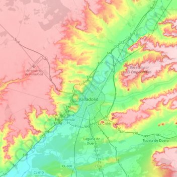
Name: Valladolid topographic map, elevation, terrain.
Location: Valladolid, Castile and León, Spain (41.52313 -4.92818 41.81551 -4.63081)
Average elevation: 768 m
Minimum elevation: 672 m
Maximum elevation: 868 m
Other topographic maps
Click on a map to view its topography, its elevation and its terrain.
Yacimiento arqueológico La Edrada
Spain > Castile and León > El Bierzo > Cacabelos
Average elevation: 493 m
Poblado del Salto de Aldeadávila
Spain > Castile and León > Aldeadávila de la Ribera
Average elevation: 535 m
Castrillo Mota de Judíos
Spain > Castile and León > Castrillo Mota de Judíos > Castrillo Mota de Judíos
Average elevation: 801 m