
City of London topographic map
Interactive map
Click on the map to display elevation.
About this map
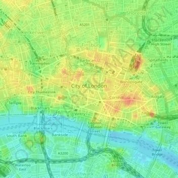
Name: City of London topographic map, elevation, terrain.
Location: City of London, Greater London, England, United Kingdom (51.50687 -0.11383 51.52331 -0.07276)
Average elevation: 21 m
Minimum elevation: -1 m
Maximum elevation: 44 m
The elevation of the City ranges from sea level at the Thames to 21.6 metres (71 ft) at the junction of High Holborn and Chancery Lane. Two small but notable hills are within the historic core, Ludgate Hill to the west and Cornhill to the east. Between them ran the Walbrook, one of the many "lost" rivers or streams of London (another is the Fleet).
Other topographic maps
Click on a map to view its topography, its elevation and its terrain.
London
United Kingdom > England > London
London, Greater London, England, SW1A 2DX, United Kingdom
Average elevation: 42 m
South East England
South East England, England, United Kingdom
Average elevation: 69 m
Northamptonshire
Northamptonshire, England, United Kingdom
Average elevation: 97 m
London
London, Greater London, England, United Kingdom
Average elevation: 66 m
Bristol
United Kingdom > England > City of Bristol
Bristol, City of Bristol, West of England, England, United Kingdom
Average elevation: 55 m
West Yorkshire
West Yorkshire, England, United Kingdom
Average elevation: 172 m
Woking
United Kingdom > England > Surrey
Woking, Surrey, England, United Kingdom
Average elevation: 38 m
St Albans
United Kingdom > England > Hertfordshire > St Albans
St Albans, Hertfordshire, East of England, England, United Kingdom
Average elevation: 100 m
Newcastle upon Tyne
Newcastle upon Tyne, North of Tyne, England, United Kingdom
Average elevation: 57 m
Dorset
United Kingdom > England > Talbot Village
Dorset, Alder Road, Branksome, Talbot Village, Bournemouth, Christchurch and Poole, South West England, England, BH12 5BJ, United Kingdom
Average elevation: 57 m
North Yorkshire
North Yorkshire, Yorkshire and the Humber, England, United Kingdom
Average elevation: 153 m
Somerset
Somerset, South West England, England, United Kingdom
Average elevation: 87 m
Hampshire
Hampshire, South East, England, United Kingdom
Average elevation: 73 m
Norwich
United Kingdom > England > Norfolk
Norwich, Norfolk, England, United Kingdom
Average elevation: 28 m
Sheffield
Sheffield, South Yorkshire, England, United Kingdom
Average elevation: 168 m
Liverpool
Liverpool, Liverpool City Region, England, United Kingdom
Average elevation: 26 m
Plymouth
United Kingdom > England > Devon > Plymouth
Plymouth, Devon, South West England, England, PL1 1HH, United Kingdom
Average elevation: 81 m
Nottingham
United Kingdom > England > Nottinghamshire
Nottingham, England, United Kingdom
Average elevation: 56 m
Green Ore
United Kingdom > England > Somerset
Green Ore, Somerset, England, BA5 3ER, United Kingdom
Average elevation: 240 m
Copt Hewick
United Kingdom > England > North Yorkshire
Copt Hewick, North Yorkshire, England, United Kingdom
Average elevation: 39 m
Leeds
United Kingdom > England > Leeds
Leeds, Yorkshire and the Humber, England, LS1 6AL, United Kingdom
Average elevation: 94 m
Buxton
United Kingdom > England > Derbyshire > High Peak
Buxton, High Peak, Derbyshire, England, United Kingdom
Average elevation: 334 m
Shropshire
Shropshire, West Midlands, England, United Kingdom
Average elevation: 166 m
Kent
United Kingdom > England > Sevenoaks
Kent, Beechenlea Lane, Swanley, Sevenoaks, Kent, South East, England, BR8 7PR, United Kingdom
Average elevation: 37 m
Fenland
United Kingdom > England > Cambridgeshire > Fenland
Fenland, Cambridgeshire, East of England, England, United Kingdom
Average elevation: 4 m
North Norfolk
United Kingdom > England > Norfolk
North Norfolk, Norfolk, England, United Kingdom
Average elevation: 26 m
City of Durham
United Kingdom > England > County Durham > Durham
City of Durham, Durham, County Durham, North East, England, United Kingdom
Average elevation: 76 m
Wallington
United Kingdom > England > Northumberland
Wallington, Wallington Demesne, Northumberland, North of Tyne, England, NE61 4AR, United Kingdom
Average elevation: 161 m
Lincolnshire
Lincolnshire, East Midlands, England, United Kingdom
Average elevation: 28 m
Warminster
United Kingdom > England > Wiltshire
Warminster, Wiltshire, England, United Kingdom
Average elevation: 143 m
Wirral
Wirral, Liverpool City Region, England, United Kingdom
Average elevation: 21 m
City of London
United Kingdom > England > City of London > City of London
City of London, England, EC2V 5AE, United Kingdom
Average elevation: 42 m
West Midlands
United Kingdom > England > Warwickshire
West Midlands, Warwickshire, West Midlands Combined Authority, England, United Kingdom
Average elevation: 113 m
Cambridgeshire
Cambridgeshire, Cambridgeshire and Peterborough, England, United Kingdom
Average elevation: 32 m
Greater Manchester
Greater Manchester, England, United Kingdom
Average elevation: 141 m
Huddersfield
United Kingdom > England > Kirklees
Huddersfield, Kirklees, West Yorkshire, England, HD1 2AA, United Kingdom
Average elevation: 145 m
Portishead
United Kingdom > England > Portishead
Portishead, North Somerset, South West England, England, BS20, United Kingdom
Average elevation: 26 m
Spalding
United Kingdom > England > Lincolnshire > South Holland
Spalding, South Holland, Lincolnshire, England, United Kingdom
Average elevation: 4 m
Grimsby
United Kingdom > England > North East Lincolnshire
Grimsby, North East Lincolnshire, England, DN31 1NR, United Kingdom
Average elevation: 6 m
Skipton
United Kingdom > England > Skipton
Skipton, North Yorkshire, Yorkshire and the Humber, England, BD23 1DU, United Kingdom
Average elevation: 201 m
Stockport
Stockport, Greater Manchester, England, United Kingdom
Average elevation: 95 m
Hebden Bridge
United Kingdom > England > Calderdale
Hebden Bridge, Calderdale, West Yorkshire, England, HX7 8AT, United Kingdom
Average elevation: 277 m