
Coryton topographic map
Click on the map to display elevation.
About this map
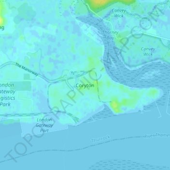
Name: Coryton topographic map, elevation, terrain.
Location: Coryton, Thurrock, Essex, England, SS17 9LR, United Kingdom (51.49482 0.49146 51.53482 0.53146)
Average elevation: 1 m
Minimum elevation: -4 m
Maximum elevation: 18 m
Essex trails, hiking, mountain biking, running and outdoor activities
Other topographic maps
Click on a map to view its topography, its elevation and its terrain.
Connaught Water
United Kingdom > England > Essex > Epping Forest > Sewardstonebury
Average elevation: 57 m
Little Easton
United Kingdom > England > Essex > Uttlesford > Little Easton
Living in the parish were Lord and Lady Brooke, the later Earl and Countess of Warwick, at Easton Lodge, who were also resident at Berwick House in the Stable Yard of St James's Palace, London, and in 1902, after elevation to title, Warwick Castle. Parish occupations in 1882 included three farmers, one of whom…
Average elevation: 88 m
Canvey Island
United Kingdom > England > Essex > Castle Point > Canvey
In 1607 the Elizabethan antiquarian William Camden noted in his work Britannia (a topographical and historical survey of all of Great Britain and Ireland) that Canvey Island (which he called Island Convennon) was documented in the 2nd century by the Alexandrian geographer Ptolemy. In his work Geographia,…
Average elevation: 10 m
Hedingham Castle
United Kingdom > England > Essex > Braintree > Castle Hedingham
Average elevation: 67 m
River Crouch
United Kingdom > England > Essex
The Crouch rises in 'The Wilderness' on the Burstead Golf course at Little Burstead. The Wilderness consists of several small ponds surrounded by a tiny area of ancient woodland. The ponds date from around 1250, when they were used for the farming of fish for Stockwell Hall, and also served as a defensive moat…
Average elevation: 20 m
Coles Green
United Kingdom > England > Essex > Uttlesford > Berden > Little London
Average elevation: 100 m
Roughtalley's Wood (South) & Epping Forest Woodland Burial Ground
United Kingdom > England > Essex > Epping Forest > Coopersale
Average elevation: 96 m
Epping Forest
United Kingdom > England > Essex > Epping Forest > Debden Green
It lies on a ridge between the valleys of the rivers Lea and Roding. It contains areas of woodland, grassland, heath, streams, bogs and ponds, and its elevation and thin gravelly soil (the result of glaciation) historically made it less suitable for agriculture. The Forest was historically managed as a common;…
Average elevation: 44 m
Stansted Mountfitchet
United Kingdom > England > Essex > Uttlesford > Stansted Mountfitchet
Average elevation: 89 m
Hanningfield Reservoir
United Kingdom > England > Essex > Chelmsford > South Hanningfield
Average elevation: 56 m
Wivenhoe Woods
United Kingdom > England > Essex > Colchester > Wivenhoe > Rowhedge
Average elevation: 18 m
Stanford Rivers
United Kingdom > England > Essex > Epping Forest > Stanford Rivers
Average elevation: 65 m
M25 Pollution Control Device
United Kingdom > England > Essex > South Ockendon
Average elevation: 19 m
Great Horkesley
United Kingdom > England > Essex > Colchester > Great Horkesley
Average elevation: 45 m