Mount Hillaby topographic map
Interactive map
Click on the map to display elevation.
About this map
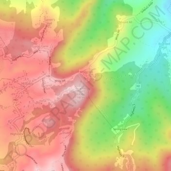
Name: Mount Hillaby topographic map, elevation, terrain.
Location: Mount Hillaby, Saint Andrew, Barbados (13.21155 -59.58136 13.21165 -59.58126)
Average elevation: 212 m
Minimum elevation: 48 m
Maximum elevation: 319 m
Other topographic maps
Click on a map to view its topography, its elevation and its terrain.
St. Margaret's
St. Margaret's, Saint John, BB20004, Barbados
Average elevation: 96 m
Market Hill
Market Hill, Saint George, BB22087, Barbados
Average elevation: 190 m
Mount Standfast
Mount Standfast, Saint James, BB24026, Barbados
Average elevation: 56 m
St. Judes
Barbados > Saint George > St. Judes
St. Judes, Saint George, Barbados
Average elevation: 215 m
Easy Hall
Barbados > Bowling Alley Hill > Easy Hall
Easy Hall, Bowling Alley Hill, Saint Joseph, BB22069, Barbados
Average elevation: 211 m
St. Lawrence
St. Lawrence, Christ Church, BB15018, Barbados
Average elevation: 17 m