
Wallis topographic map
Interactive map
Click on the map to display elevation.
About this map
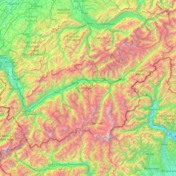
Name: Wallis topographic map, elevation, terrain.
Location: Wallis, Switzerland (45.85831 6.77063 46.65405 8.47856)
Average elevation: 1,728 m
Minimum elevation: 190 m
Maximum elevation: 4,728 m
Valais is the highest canton in terms of absolute, relative, and mean elevation. Therefore, its topography is extremely rugged, with the notable exception of the wide, glacial, Rhône valley. The latter valley dominates the geography of the canton. Many side valleys are branching off the main valley, often perpendicularly. These vary from narrow and remote to reasonably populous. On the south side of the Rhône, in the Valais Alps, some of the largest side valleys are (from east to west): the Mattertal (including the Saastal), the Val d'Anniviers, the Val d'Hérens, the Val de Bagnes and the Val d'Entremont. On the north of the Rhône, in the Bernese Alps, the Lötschental is the only large valley. East of Brig is the valley of Goms, the highest section of the Rhône Valley. The Rhône itself flows in the main valley from east to west from the Rhône Glacier down to Martigny, then at a right angle north to its mouth in Lake Geneva. After the town of Saint-Maurice, the eastern banks of the river belong to the canton of Vaud, although the western banks remain in Valais, down to Le Bouveret, on the shores of Lake Geneva. The main valley is bounded by the Bernese Alps in the north and the Valais Alps in the south, both ranges including numerous over 4,000 metre-high mountains, which are the highest in the country. Notables mountains include Monte Rosa (highest), reaching 4,634 metres (15,203 ft), and the Finsteraarhorn (most prominent), reaching 4,274 metres (14,022 ft). Other iconic mountains are the Matterhorn and the Jungfrau, for a complete list, see list of mountains of Valais. Located there are numerous glaciers including several of the largest in the Alps, such as the Aletsch Glacier and the Gorner Glacier. Other ranges situated partially in Valais are the Chablais Alps, the Mont Blanc Massif, the Uri Alps, the Gotthard Massif, and the Lepontine Alps.
Other topographic maps
Click on a map to view its topography, its elevation and its terrain.
Bern
Switzerland > Bern > Bern-Mittelland administrative district
Bern, Bern-Mittelland administrative district, Bernese Mittelland administrative region, Bern, Switzerland
Average elevation: 612 m
Prévonloup
Switzerland > Vaud > District de la Broye-Vully
Prévonloup, District de la Broye-Vully, Vaud, Switzerland
Average elevation: 744 m
Zurich
Switzerland > Zurich > District Zurich
Zurich, District Zurich, Zurich, Switzerland
Average elevation: 499 m
Gobba di Rollin
Switzerland > Wallis > Visp > Zermatt
Gobba di Rollin, Zermatt, Visp, Wallis, 3920, Switzerland
Average elevation: 3,590 m
Matterhorn
Switzerland > Wallis > Visp > Zermatt
Matterhorn, Zermatt, Visp, Wallis, 3920, Switzerland
Average elevation: 3,295 m
Armüli
Switzerland > Bern > Interlaken-Oberhasli administrative district > Interlaken
Armüli, Interlaken, Interlaken-Oberhasli administrative district, Oberland administrative region, Bern, 3800, Switzerland
Average elevation: 690 m
Zermatt
Switzerland > Wallis > Visp
Zermatt, Visp, Wallis, 3920, Switzerland
Average elevation: 2,921 m
Crastas
Switzerland > Grisons > Maloja > Sils im Engadin/Segl
Crastas, Sils im Engadin/Segl, Maloja, Grisons, 7514, Switzerland
Average elevation: 2,060 m
Nendaz
Switzerland > Wallis > Conthey
Nendaz, Conthey, Wallis, 1997, Switzerland
Average elevation: 1,771 m
Kloten
Switzerland > Zurich > Bezirk Bülach
Kloten, Bezirk Bülach, Zurich, 8302, Switzerland
Average elevation: 478 m
Vétroz
Switzerland > Wallis > Conthey
Vétroz, Conthey, Wallis, 1963, Switzerland
Average elevation: 920 m
Melide
Switzerland > Ticino > Distretto di Lugano
Melide, Circolo di Carona, Distretto di Lugano, Ticino, 6815, Switzerland
Average elevation: 405 m
Thörishaus
Switzerland > Bern > Bern-Mittelland administrative district > Köniz
Thörishaus, Köniz, Bern-Mittelland administrative district, Bernese Mittelland administrative region, Bern, 3174, Switzerland
Average elevation: 653 m
Kaiseraugst
Switzerland > Aargau > Bezirk Rheinfelden
Kaiseraugst, Bezirk Rheinfelden, Aargau, 4303, Switzerland
Average elevation: 293 m
Sisseln
Switzerland > Aargau > Bezirk Laufenburg
Sisseln, Bezirk Laufenburg, Aargau, 4334, Switzerland
Average elevation: 323 m
Wacht
Switzerland > Zurich > Bezirk Hinwil > Rüti (ZH)
Wacht, Rüti (ZH), Bezirk Hinwil, Zurich, 8630, Switzerland
Average elevation: 511 m
Surcuolm
Switzerland > Grisons > Surselva > Obersaxen-Mundaun
Surcuolm, Obersaxen-Mundaun, Surselva, Grisons, 7138, Switzerland
Average elevation: 1,311 m
Saint-Blaise
Saint-Blaise, Neuchâtel, 2072, Switzerland
Average elevation: 687 m
Cossonay
Switzerland > Vaud > District de Morges
Cossonay, District de Morges, Vaud, 1304, Switzerland
Average elevation: 533 m
Oberriet
Switzerland > St. Gallen > Wahlkreis Rheintal
Oberriet, Wahlkreis Rheintal, St. Gallen, Switzerland
Average elevation: 528 m
Davosersee
Switzerland > Grisons > Prättigau/Davos > Davos
Davosersee, Davos Dorf, Davos, Prättigau/Davos, Grisons, Switzerland
Average elevation: 1,722 m
Abtwil
Switzerland > Aargau > Bezirk Muri
Abtwil, Bezirk Muri, Aargau, 5646, Switzerland
Average elevation: 539 m
Konolfingen
Switzerland > Bern > Bern-Mittelland administrative district
Konolfingen, Bern-Mittelland administrative district, Bernese Mittelland administrative region, Bern, Switzerland
Average elevation: 745 m
Uitikon
Switzerland > Zurich > Bezirk Dietikon
Uitikon, Bezirk Dietikon, Zurich, 8142, Switzerland
Average elevation: 542 m
Bignasco
Switzerland > Ticino > Distretto di Vallemaggia
Bignasco, Cevio, Circolo della Rovana, Distretto di Vallemaggia, Ticino, 6676, Switzerland
Average elevation: 956 m
Hospental
Switzerland > Uri > Korporation Ursern
Hospental, Korporation Ursern, Uri, 6493, Switzerland
Average elevation: 2,144 m
Les Maresses
Switzerland > Wallis > Hérens > Mont-Noble > Vernamiège
Les Maresses, Vernamiège, Mont-Noble, Hérens, Wallis, 1961, Switzerland
Average elevation: 1,657 m
Laufen
Switzerland > Basel-Landschaft > Bezirk Laufen
Laufen, Bezirk Laufen, Basel-Landschaft, 4242, Switzerland
Average elevation: 455 m
Morrens
Switzerland > Vaud > District du Gros-de-Vaud
Morrens, District du Gros-de-Vaud, Vaud, 1054, Switzerland
Average elevation: 672 m
Wallisellen
Switzerland > Zurich > Bezirk Bülach
Wallisellen, Bezirk Bülach, Zurich, Switzerland
Average elevation: 451 m
Pied de Ville
Switzerland > Wallis > Entremont > Sembrancher
Pied de Ville, La Gravenne, Sembrancher, Entremont, Wallis, 2303, Switzerland
Average elevation: 960 m
Gletterens
Switzerland > Fribourg > District de la Broye
Gletterens, District de la Broye, Fribourg, 1544, Switzerland
Average elevation: 464 m
Drapel
Switzerland > Vaud > District d'Aigle > Aigle
Drapel, Aigle, District d'Aigle, Vaud, 1860, Switzerland
Average elevation: 716 m
Lac de Chermignon
Switzerland > Wallis > Sierre > Plans-Mayens
Lac de Chermignon, Plans-Mayens, Lens, Sierre, Wallis, 3960, Switzerland
Average elevation: 1,548 m
Gähwil
Switzerland > St. Gallen > Wahlkreis Toggenburg > Kirchberg (SG)
Gähwil, Kirchberg (SG), Wahlkreis Toggenburg, St. Gallen, 9534, Switzerland
Average elevation: 778 m
Büel
Switzerland > Grisons > Viamala > Avers
Büel, Avers, Viamala, Grisons, 7447, Switzerland
Average elevation: 2,648 m
Schloss Meggenhorn
Switzerland > Lucerne > Meggen
Schloss Meggenhorn, 53, Meggenhornstrasse, Lerchenbühl, Meggen, Lucerne, 6045, Switzerland
Average elevation: 450 m
Hochwald
Switzerland > Solothurn > Amtei Dorneck-Thierstein
Hochwald, Bezirk Dorneck, Amtei Dorneck-Thierstein, Solothurn, 4146, Switzerland
Average elevation: 615 m
Lützelflüh
Switzerland > Bern > Emmental administrative district
Lützelflüh, Emmental administrative district, Emmental-Oberaargau administrative region, Bern, Switzerland
Average elevation: 730 m
Braunwald
Switzerland > Glarus > Glarus Süd
Braunwald, Glarus Süd, Glarus, 8784, Switzerland
Average elevation: 1,215 m
Baule
Switzerland > Wallis > Hérens > Saint-Martin (VS) > St-Martin VS
Baule, St-Martin VS, Saint-Martin (VS), Hérens, Wallis, 1969, Switzerland
Average elevation: 1,439 m
Langenthal
Switzerland > Bern > Oberaargau administrative district
Langenthal, Oberaargau administrative district, Emmental-Oberaargau administrative region, Bern, Switzerland
Average elevation: 497 m
Berneck
Switzerland > St. Gallen > Wahlkreis Rheintal
Berneck, Wahlkreis Rheintal, St. Gallen, 9442, Switzerland
Average elevation: 561 m
Yverdon-les-Bains
Switzerland > Vaud > District du Jura-Nord vaudois
Yverdon-les-Bains, District du Jura-Nord vaudois, Vaud, Switzerland
Average elevation: 480 m
Raviscé
Switzerland > Grisons > Bernina > San Carlo
Raviscé, San Carlo, Poschiavo, Bernina, Grisons, 7741, Switzerland
Average elevation: 1,529 m
Glattfelden
Switzerland > Zurich > Bezirk Bülach
Glattfelden, Bezirk Bülach, Zurich, 8192, Switzerland
Average elevation: 413 m
Saillon
Switzerland > Wallis > Martigny
Saillon, Martigny, Wallis, 1913, Switzerland
Average elevation: 975 m