
Kampung Tanjung Pari topographic map
Interactive map
Click on the map to display elevation.
About this map
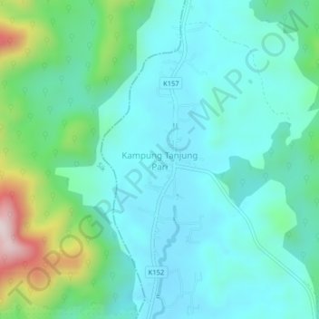
Name: Kampung Tanjung Pari topographic map, elevation, terrain.
Location: Kampung Tanjung Pari, Baling, Kedah, Malaysia (5.86379 100.87198 5.90379 100.91198)
Average elevation: 220 m
Minimum elevation: 109 m
Maximum elevation: 640 m
Other topographic maps
Click on a map to view its topography, its elevation and its terrain.
Kampung Baru Bagan Samak
Malaysia > Kedah > Permatang Kerat Telunjuk > Kampung Baru Bagan Samak
Average elevation: 3 m
Kemajuan Tanah (FELDA) Lubok Merbau
Malaysia > Kedah > Kemajuan Tanah (FELDA) Lubok Merbau
Average elevation: 60 m