
Berlin topographic map
Interactive map
Click on the map to display elevation.
About this map
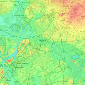
Name: Berlin topographic map, elevation, terrain.
Location: Berlin, Germany (52.33824 13.08835 52.67551 13.76116)
Average elevation: 48 m
Minimum elevation: 26 m
Maximum elevation: 112 m
Berlin straddles the banks of the Spree, which flows into the Havel (a tributary of the Elbe) in the western borough of Spandau. Among the city's main topographical features are the many lakes in the western and southeastern boroughs formed by the Spree, Havel and Dahme, the largest of which is Lake Müggelsee. Due to its location in the European Plain, Berlin is influenced by a temperate seasonal climate. About one-third of the city's area is composed of forests, parks, gardens, rivers, canals, and lakes. The city lies in the Central German dialect area, the Berlin dialect being a variant of the Lusatian-New Marchian dialects.
Other topographic maps
Click on a map to view its topography, its elevation and its terrain.
Husum
Germany > Schleswig-Holstein > Northern Friesland
Husum, Northern Friesland, Schleswig-Holstein, 25813, Germany
Average elevation: 8 m
Frankfurt am Main
Germany > Hesse > Frankfurt am Main
Frankfurt am Main, Hesse, 60311, Germany
Average elevation: 162 m
Stuttgart
Germany > Baden-Württemberg > Stuttgart
Stuttgart, Regierungsbezirk Stuttgart, Baden-Württemberg, 70173, Germany
Average elevation: 353 m
Aachen
Germany > North Rhine-Westphalia > Städteregion Aachen
Aachen, Städteregion Aachen, North Rhine-Westphalia, Germany
Average elevation: 225 m
Auw bei Prüm
Germany > Rhineland-Palatinate > Eifelkreis Bitburg-Prüm
Auw bei Prüm, Prüm, Eifelkreis Bitburg-Prüm, Rhineland-Palatinate, Germany
Average elevation: 552 m
Duren
Germany > North Rhine – Westphalia > Kreis Düren
Duren, Kreis Düren, North Rhine – Westphalia, Germany
Average elevation: 145 m
Soll
Germany > Brandenburg > Potsdam-Mittelmark > Cammer
Soll, Cammer, Planebruch, Brück, Potsdam-Mittelmark, Brandenburg, 14822, Germany
Average elevation: 46 m
Cologne
Germany > North Rhine – Westphalia
Cologne, North Rhine – Westphalia, Germany
Average elevation: 69 m
Goslar
Germany > Lower Saxony > Landkreis Goslar
Goslar, Landkreis Goslar, Lower Saxony, Germany
Average elevation: 312 m
Mahd
Germany > Bavaria > Landkreis Deggendorf > Osterhofen > Arbing
Mahd, Arbing, Osterhofen, Landkreis Deggendorf, Bavaria, 94550, Germany
Average elevation: 311 m
Witten
Germany > North Rhine – Westphalia > Ennepe-Ruhr-Kreis
Witten, Ennepe-Ruhr-Kreis, North Rhine – Westphalia, Germany
Average elevation: 137 m
Wind
Germany > Bavaria > Landkreis Bamberg
Wind, Pommersfelden, Landkreis Bamberg, Bavaria, 96178, Germany
Average elevation: 284 m
Bremen
Germany > Free Hanseatic City of Bremen
Bremen, Free Hanseatic City of Bremen, Germany
Average elevation: 11 m
Langenlonsheim
Germany > Rhineland-Palatinate > Landkreis Bad Kreuznach
Langenlonsheim, Langenlonsheim-Stromberg, Landkreis Bad Kreuznach, Rhineland-Palatinate, Germany
Average elevation: 135 m
Geisa
Germany > Thuringia > Wartburgkreis > Geisa
Geisa, Wartburgkreis, Thuringia, 36419, Germany
Average elevation: 332 m
Kirchsahr
Germany > Rhineland-Palatinate > Landkreis Ahrweiler
Kirchsahr, Altenahr, Landkreis Ahrweiler, Rhineland-Palatinate, Germany
Average elevation: 367 m
Herscheid
Germany > North Rhine – Westphalia > Märkischer Kreis
Herscheid, Märkischer Kreis, North Rhine – Westphalia, 58849, Germany
Average elevation: 441 m
Nürburg
Germany > Rhineland-Palatinate > Landkreis Ahrweiler
Nürburg, Adenau, Landkreis Ahrweiler, Rhineland-Palatinate, Germany
Average elevation: 560 m
Brome
Germany > Lower Saxony > Gifhorn
Brome, Samtgemeinde Brome, Gifhorn, Lower Saxony, 38465, Germany
Average elevation: 74 m
Celle
Germany > Lower Saxony > Landkreis Celle
Celle, Landkreis Celle, Lower Saxony, Germany
Average elevation: 48 m
Niederplanitz
Germany > Saxony > Zwickau > Zwickau
Niederplanitz, Zwickau-Süd, Zwickau, Langenweißbach, Zwickau, Saxony, 08134, Germany
Average elevation: 316 m
Hartmannsdorf
Germany > Thuringia > Saale-Holzland-Kreis
Hartmannsdorf, Heideland-Elstertal-Schkölen, Saale-Holzland-Kreis, Thuringia, Germany
Average elevation: 197 m
Schönewalde
Germany > Brandenburg > Elbe-Elster
Schönewalde, Elbe-Elster, Brandenburg, Germany
Average elevation: 86 m
Erding
Germany > Bavaria > Landkreis Erding > Erding
Erding, Landkreis Erding, Bavaria, 85435, Germany
Average elevation: 460 m
Bell
Germany > Rhineland-Palatinate > Landkreis Mayen-Koblenz
Bell, Mendig, Landkreis Mayen-Koblenz, Rhineland-Palatinate, Germany
Average elevation: 383 m
08289
Germany > Saxony > Erzgebirgskreis > Schneeberg
08289, Griesbach, Schneeberg, Erzgebirgskreis, Saxony, Germany
Average elevation: 505 m
70771
Germany > Baden-Württemberg > Landkreis Esslingen > Leinfelden
70771, Leinfelden, Leinfelden-Echterdingen, Landkreis Esslingen, Baden-Württemberg, Germany
Average elevation: 437 m
Hoya
Germany > Lower Saxony > Landkreis Nienburg/Weser
Hoya, Samtgemeinde Grafschaft Hoya, Landkreis Nienburg/Weser, Lower Saxony, Germany
Average elevation: 18 m
Wittenbeck
Germany > Mecklenburg-Vorpommern > Landkreis Rostock
Wittenbeck, Bad Doberan-Land, Landkreis Rostock, Mecklenburg-Vorpommern, Germany
Average elevation: 34 m
Cleves
Germany > North Rhine – Westphalia > Kreis Kleve > Cleves
Cleves, Bedburg-Hau, Kreis Kleve, North Rhine – Westphalia, 47533, Germany
Average elevation: 35 m
Wernigerode
Germany > Saxony-Anhalt > Landkreis Harz
Wernigerode, Landkreis Harz, Saxony-Anhalt, Germany
Average elevation: 381 m
Mainhardt
Germany > Baden-Württemberg > Landkreis Schwäbisch Hall
Mainhardt, Landkreis Schwäbisch Hall, Baden-Württemberg, 74535, Germany
Average elevation: 455 m
Nebelhorn
Germany > Bavaria > Landkreis Oberallgäu
Nebelhorn, Oberstdorf, Landkreis Oberallgäu, Bavaria, Germany
Average elevation: 1,792 m
Bad Muskau - Mužakow
Bad Muskau - Mužakow, Bad Muskau, Görlitz, Saxony, Germany
Average elevation: 130 m
Weiden in der Oberpfalz
Weiden in der Oberpfalz, Bavaria, 92637, Germany
Average elevation: 460 m
Schnaittenbach
Germany > Bavaria > Landkreis Amberg-Sulzbach
Schnaittenbach, Landkreis Amberg-Sulzbach, Bavaria, 92253, Germany
Average elevation: 480 m
Pursruck
Germany > Bavaria > Landkreis Amberg-Sulzbach
Pursruck, Freudenberg, Landkreis Amberg-Sulzbach, Bavaria, 92272, Germany
Average elevation: 496 m