
Make a donation
Gear up for your next adventure:
As an Amazon Associate, this site earns from qualifying purchases at no extra cost to you.
Tewkesbury topographic map
Click on the map to display elevation.
Make a donation
Gear up for your next adventure:
As an Amazon Associate, this site earns from qualifying purchases at no extra cost to you.
About this map
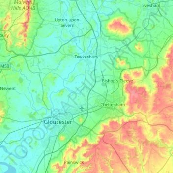
Name: Tewkesbury topographic map, elevation, terrain.
Location: Tewkesbury, Gloucestershire, England, United Kingdom (51.81930 -2.35275 52.05056 -1.80169)
Average elevation: 89 m
Minimum elevation: 2 m
Maximum elevation: 419 m
Gloucestershire trails, hiking, mountain biking, running and outdoor activities
Make a donation
Gear up for your next adventure:
As an Amazon Associate, this site earns from qualifying purchases at no extra cost to you.
Other topographic maps
Click on a map to view its topography, its elevation and its terrain.
Make a donation
Gear up for your next adventure:
As an Amazon Associate, this site earns from qualifying purchases at no extra cost to you.
Joyford
United Kingdom > England > Gloucestershire > Forest of Dean > Berry Hill
Average elevation: 188 m
Jubilee Playing Field & Athletics Track
United Kingdom > England > Gloucestershire > Stroud > Cam > Draycott
Average elevation: 45 m
Make a donation
Gear up for your next adventure:
As an Amazon Associate, this site earns from qualifying purchases at no extra cost to you.
Duntisbourne Abbots
United Kingdom > England > Gloucestershire > Cotswold District
Average elevation: 204 m
Make a donation
Gear up for your next adventure:
As an Amazon Associate, this site earns from qualifying purchases at no extra cost to you.
Make a donation
Gear up for your next adventure:
As an Amazon Associate, this site earns from qualifying purchases at no extra cost to you.
Stow-on-the-Wold
United Kingdom > England > Gloucestershire > Cotswold District
Average elevation: 163 m
Lower Slaughter
United Kingdom > England > Gloucestershire > Cotswold District
Average elevation: 160 m
Make a donation
Gear up for your next adventure:
As an Amazon Associate, this site earns from qualifying purchases at no extra cost to you.
Bream Meend
United Kingdom > England > Gloucestershire > Forest of Dean > Bream
Average elevation: 140 m
Make a donation
Gear up for your next adventure:
As an Amazon Associate, this site earns from qualifying purchases at no extra cost to you.
Highbury
United Kingdom > England > Gloucestershire > Forest of Dean > Lydney > Allaston
Average elevation: 65 m
Make a donation
Gear up for your next adventure:
As an Amazon Associate, this site earns from qualifying purchases at no extra cost to you.
Grange Village
United Kingdom > England > Gloucestershire > Forest of Dean > Littledean
Average elevation: 98 m
Make a donation
Gear up for your next adventure:
As an Amazon Associate, this site earns from qualifying purchases at no extra cost to you.
Make a donation
Gear up for your next adventure:
As an Amazon Associate, this site earns from qualifying purchases at no extra cost to you.
Calcot
United Kingdom > England > Gloucestershire > Cotswold District > Coln Rogers
Average elevation: 151 m
Make a donation
Gear up for your next adventure:
As an Amazon Associate, this site earns from qualifying purchases at no extra cost to you.
Bamfurlong
United Kingdom > England > Gloucestershire > Tewkesbury > Staverton
Average elevation: 34 m
Make a donation
Gear up for your next adventure:
As an Amazon Associate, this site earns from qualifying purchases at no extra cost to you.
Saunders Green
United Kingdom > England > Gloucestershire > Forest of Dean > Whitecroft
Average elevation: 111 m
Bakers Hill
United Kingdom > England > Gloucestershire > Forest of Dean > Broadwell
Average elevation: 195 m
Make a donation
Gear up for your next adventure:
As an Amazon Associate, this site earns from qualifying purchases at no extra cost to you.
Make a donation
Gear up for your next adventure:
As an Amazon Associate, this site earns from qualifying purchases at no extra cost to you.
Lydney Hub
United Kingdom > England > Gloucestershire > Forest of Dean > Lydney > Allaston > Tutnalls
Average elevation: 42 m
Caudle Green
United Kingdom > England > Gloucestershire > Cotswold District > Brimpsfield
Average elevation: 234 m
Newent Woods
United Kingdom > England > Gloucestershire > Forest of Dean > May Hill
Average elevation: 157 m
Make a donation
Gear up for your next adventure:
As an Amazon Associate, this site earns from qualifying purchases at no extra cost to you.
Make a donation
Gear up for your next adventure:
As an Amazon Associate, this site earns from qualifying purchases at no extra cost to you.
Make a donation
Gear up for your next adventure:
As an Amazon Associate, this site earns from qualifying purchases at no extra cost to you.
Make a donation
Gear up for your next adventure:
As an Amazon Associate, this site earns from qualifying purchases at no extra cost to you.
Plump Hill
United Kingdom > England > Gloucestershire > Forest of Dean > Abenhall > Plump Hill
Average elevation: 195 m
Make a donation
Gear up for your next adventure:
As an Amazon Associate, this site earns from qualifying purchases at no extra cost to you.
Crumpmeadow Inclosure
United Kingdom > England > Gloucestershire > Forest of Dean > Cinderford
Average elevation: 167 m
Botany Bay Wood
United Kingdom > England > Gloucestershire > Cotswold District > Stow-on-the-Wold
Average elevation: 171 m
Make a donation
Gear up for your next adventure:
As an Amazon Associate, this site earns from qualifying purchases at no extra cost to you.
Make a donation
Gear up for your next adventure:
As an Amazon Associate, this site earns from qualifying purchases at no extra cost to you.
Lower Berry Hill
United Kingdom > England > Gloucestershire > Forest of Dean > Berry Hill
Average elevation: 193 m
Yorkley Wood
United Kingdom > England > Gloucestershire > Forest of Dean > Pillowell > Yorkley Bottom
Average elevation: 122 m
Make a donation
Gear up for your next adventure:
As an Amazon Associate, this site earns from qualifying purchases at no extra cost to you.
Trewsbury Mead
United Kingdom > England > Gloucestershire > Cotswold District
Average elevation: 122 m
Make a donation
Gear up for your next adventure:
As an Amazon Associate, this site earns from qualifying purchases at no extra cost to you.
Make a donation
Gear up for your next adventure:
As an Amazon Associate, this site earns from qualifying purchases at no extra cost to you.
Little Shurdington
United Kingdom > England > Gloucestershire > Tewkesbury > Bentham
Average elevation: 112 m
Timbercombe
United Kingdom > England > Gloucestershire > Cheltenham > Charlton Kings
Average elevation: 159 m
Make a donation
Gear up for your next adventure:
As an Amazon Associate, this site earns from qualifying purchases at no extra cost to you.
Make a donation
Gear up for your next adventure:
As an Amazon Associate, this site earns from qualifying purchases at no extra cost to you.