
Putney topographic map
Interactive map
Click on the map to display elevation.
About this map
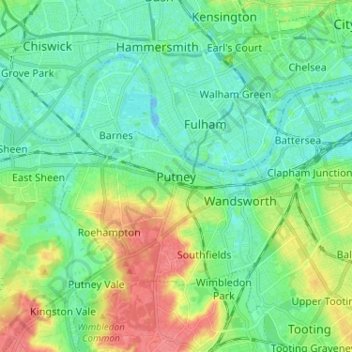
Name: Putney topographic map, elevation, terrain.
Location: Putney, Greater London, England, SW15 1RG, United Kingdom (51.42255 -0.25675 51.50255 -0.17675)
Average elevation: 18 m
Minimum elevation: -8 m
Maximum elevation: 59 m
Putney Heath is around 400 acres (160 hectares) less the nascent A3 road in size and rises to 45 metres (148 ft) above sea level. Because of its elevation, from 1796 to 1816 Putney Heath hosted a station in the shutter telegraph chain, which connected the Admiralty in London to its naval ships in Portsmouth. One of 10 signal stations with telescopes making observation of the next station's signal, a message could be sent from the Admiralty to Portsmouth within 15 minutes. This was replaced by a semaphore station, which was part of a semaphore line that operated between 1822 and 1847.
Other topographic maps
Click on a map to view its topography, its elevation and its terrain.
London
United Kingdom > England > London
London, Greater London, England, SW1A 2DX, United Kingdom
Average elevation: 42 m
Bristol
United Kingdom > England > City of Bristol
Bristol, City of Bristol, West of England, England, United Kingdom
Average elevation: 55 m
London
London, Greater London, England, United Kingdom
Average elevation: 66 m
Liverpool
Liverpool, Liverpool City Region, England, United Kingdom
Average elevation: 26 m
Cambridge
United Kingdom > England > Cambridge
Cambridge, Cambridgeshire, East of England, England, United Kingdom
Average elevation: 18 m
Norwich
United Kingdom > England > Norfolk
Norwich, Norfolk, England, United Kingdom
Average elevation: 28 m
Nottingham
United Kingdom > England > Nottinghamshire
Nottingham, England, United Kingdom
Average elevation: 56 m
Huddersfield
United Kingdom > England > Kirklees
Huddersfield, Kirklees, West Yorkshire, England, HD1 2AA, United Kingdom
Average elevation: 145 m
Birmingham
Birmingham, West Midlands Combined Authority, England, United Kingdom
Average elevation: 138 m
Sheffield
Sheffield, South Yorkshire, England, United Kingdom
Average elevation: 168 m
City of London
United Kingdom > England > City of London > City of London
City of London, England, EC2V 5AE, United Kingdom
Average elevation: 42 m
West Midlands
United Kingdom > England > Warwickshire
West Midlands, Warwickshire, West Midlands Combined Authority, England, United Kingdom
Average elevation: 113 m
Peak District National Park
United Kingdom > England > Derbyshire
Peak District National Park, Derbyshire, South Yorkshire, England, United Kingdom
Average elevation: 225 m
Manchester
Manchester, Greater Manchester, England, United Kingdom
Average elevation: 66 m
Oxford
United Kingdom > England > Oxfordshire
Oxford, Oxfordshire, England, United Kingdom
Average elevation: 81 m
Lincoln
United Kingdom > England > Lincolnshire
Lincoln, Lincolnshire, England, United Kingdom
Average elevation: 29 m
Lake District National Park
Lake District National Park, England, United Kingdom
Average elevation: 206 m
Brighton
United Kingdom > England > Brighton and Hove
Brighton, Brighton and Hove, England, United Kingdom
Average elevation: 64 m
Plymouth
United Kingdom > England > Devon > Plymouth
Plymouth, Devon, South West England, England, PL1 1HH, United Kingdom
Average elevation: 81 m
Shropshire
Shropshire, West Midlands, England, United Kingdom
Average elevation: 166 m
Greater Manchester
Greater Manchester, England, United Kingdom
Average elevation: 141 m
Cliffe
United Kingdom > England > Medway
Cliffe, Medway, England, ME3 7RH, United Kingdom
Average elevation: 5 m
Greenwich
United Kingdom > England > London
Greenwich, London, Greater London, England, SE10 9HF, United Kingdom
Average elevation: 20 m
Lincolnshire
Lincolnshire, East Midlands, England, United Kingdom
Average elevation: 28 m
Durham
United Kingdom > England > County Durham
Durham, County Durham, North East, England, DH1 3NG, United Kingdom
Average elevation: 119 m
Leeds
United Kingdom > England > Leeds
Leeds, Yorkshire and the Humber, England, LS1 6AL, United Kingdom
Average elevation: 94 m
South East England
South East England, England, United Kingdom
Average elevation: 69 m
Brandon
United Kingdom > England > Lincolnshire > South Kesteven
Brandon, Hough-on-the-Hill, South Kesteven, Lincolnshire, England, NG32 2AP, United Kingdom
Average elevation: 25 m
Coventry
Coventry, West Midlands Combined Authority, England, United Kingdom
Average elevation: 99 m
Newcastle upon Tyne
Newcastle upon Tyne, North of Tyne, England, United Kingdom
Average elevation: 57 m
Guildford
United Kingdom > England > Surrey
Guildford, Surrey, England, United Kingdom
Average elevation: 74 m
Luxted
United Kingdom > England > London
Luxted, London Borough of Bromley, London, Greater London, England, BR6 7JU, United Kingdom
Average elevation: 167 m
East of England
East of England, England, United Kingdom
Average elevation: 39 m
Fulwood Row
United Kingdom > England > Lancashire > Preston
Fulwood Row, Preston, Lancashire, England, PR2 9PD, United Kingdom
Average elevation: 53 m
Dorset
United Kingdom > England > Talbot Village
Dorset, Alder Road, Branksome, Talbot Village, Bournemouth, Christchurch and Poole, South West England, England, BH12 5BJ, United Kingdom
Average elevation: 57 m
Falmouth
United Kingdom > England > Falmouth
Falmouth, Cornwall, South West England, England, TR11 3AT, United Kingdom
Average elevation: 33 m
Bath
United Kingdom > England > Bath and North East Somerset
Bath, Bath and North East Somerset, West of England, England, United Kingdom
Average elevation: 100 m
Doncaster
Doncaster, South Yorkshire, England, United Kingdom
Average elevation: 31 m
Peterborough
United Kingdom > England > City of Peterborough
Peterborough, City of Peterborough, Cambridgeshire and Peterborough, England, PE1 1XH, United Kingdom
Average elevation: 17 m
Lower Stow Bedon
United Kingdom > England > Norfolk > Breckland District
Lower Stow Bedon, Stow Bedon, Breckland District, Norfolk, England, NR17 1EL, United Kingdom
Average elevation: 41 m
New Forest National Park
United Kingdom > England > Hampshire
New Forest National Park, Hampshire, England, United Kingdom
Average elevation: 34 m