
Kampung Bukit Jagong topographic map
Interactive map
Click on the map to display elevation.
About this map
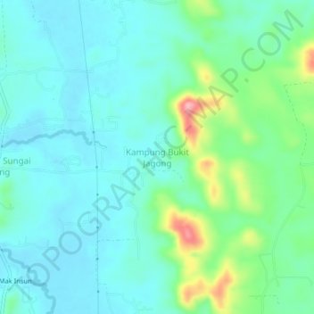
Name: Kampung Bukit Jagong topographic map, elevation, terrain.
Location: Kampung Bukit Jagong, Pendang, Kedah, Malaysia (5.90903 100.53442 5.94903 100.57442)
Average elevation: 40 m
Minimum elevation: 8 m
Maximum elevation: 152 m
Other topographic maps
Click on a map to view its topography, its elevation and its terrain.
Kampung Baru Bagan Samak
Malaysia > Kedah > Permatang Kerat Telunjuk > Kampung Baru Bagan Samak
Average elevation: 3 m
Kemajuan Tanah (FELDA) Lubok Merbau
Malaysia > Kedah > Kemajuan Tanah (FELDA) Lubok Merbau
Average elevation: 60 m