
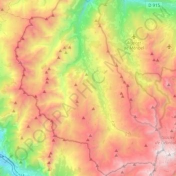
Saint-Martin-de-Belleville topographic map
Interactive map
Click on the map to display elevation.
About this map
Name: Saint-Martin-de-Belleville topographic map, elevation, terrain.
Average elevation: 1,989 m
Minimum elevation: 521 m
Maximum elevation: 3,533 m
Other topographic maps
Click on a map to view its topography, its elevation and its terrain.
Val Thorens
France > Auvergne-Rhône-Alpes > Savoy
Val Thorens ([val tɔʁɑ̃]) is a ski town in the Tarentaise Valley in the French Alps at an altitude of 2,300 m (7,500 ft). It is located in the commune of Saint-Martin-de-Belleville in the Savoie department. The resort forms part of the Les Trois Vallées ski area which, with over 600 km of slopes, is one…
Average elevation: 2,516 m
73210
France > Auvergne-Rhône-Alpes > Savoy > La Plagne-Tarentaise > Sangot
Average elevation: 1,766 m
Plagne Villages
France > Auvergne-Rhône-Alpes > Savoy > La Plagne-Tarentaise
Average elevation: 2,104 m
Praranger
France > Auvergne-Rhône-Alpes > Savoy > Saint-Martin-de-Belleville
Average elevation: 1,867 m
Tignes
France > Auvergne-Rhône-Alpes > Savoy
The terrain of valley lends itself to more challenging skiing, with advanced skiers often opting for the resort as their preferred ski area. The town has however strived to improve its appeal to beginner and intermediate skiers with the introduction of easier runs lower down in the valley towards…
Average elevation: 2,520 m
Le Chantel
France > Auvergne-Rhône-Alpes > Savoy > Bourg-Saint-Maurice > Arc 1800
Average elevation: 1,770 m
Les Ménuires
France > Auvergne-Rhône-Alpes > Savoy
The resort was founded in 1964 and has an altitude range of 1,850 m (6,070 ft).
Average elevation: 2,063 m
Les Fontanettes
France > Auvergne-Rhône-Alpes > Savoy > Saint-Martin-de-Belleville
Average elevation: 2,085 m
Col de l'Iseran
France > Auvergne-Rhône-Alpes > Savoy > Bonneval-sur-Arc
On both sides of the Col de l'Iseran, mountain pass cycling milestones mark the distance to the summit, the current altitude, and the average slope in the following kilometre.
Average elevation: 2,779 m
Puy Gris
France > Auvergne-Rhône-Alpes > Savoy > Saint-Colomban-des-Villards
Average elevation: 2,469 m
Le Grand Morétan
France > Auvergne-Rhône-Alpes > Savoy > Saint-Colomban-des-Villards
Average elevation: 2,307 m
Plagne Centre
France > Auvergne-Rhône-Alpes > Savoy > La Plagne-Tarentaise > Plagne Centre
Average elevation: 2,078 m
Saint-Jean-de-Maurienne
France > Auvergne-Rhône-Alpes > Savoy > Saint-Jean-de-Maurienne > Saint-Jean-de-Maurienne
Average elevation: 1,089 m
Lac supérieur de Rhêmes-Golette
France > Auvergne-Rhône-Alpes > Savoy > Tignes
Average elevation: 3,047 m
La Toussuire
France > Auvergne-Rhône-Alpes > Savoy > Fontcouverte-la-Toussuire
Average elevation: 1,710 m
Saint-Michel-de-Maurienne
France > Auvergne-Rhône-Alpes > Savoy
Saint-Michel-de-Maurienne has a oceanic climate (Köppen climate classification Cfb). The station is located at an altitude of 700 m (2,300 ft); due to its location on a leeward slope, there is significantly less precipitation than nearby areas. It is quite common to exceed 30 °C (86 °F) in summer, sometimes…
Average elevation: 1,590 m
Sainte-Foy-Tarentaise
France > Auvergne-Rhône-Alpes > Savoy > Sainte-Foy-Tarentaise
Average elevation: 2,136 m
Plagne Montalbert
France > Auvergne-Rhône-Alpes > Savoy > Aime-la-Plagne > Plagne Montalbert
Average elevation: 1,188 m
Saint-François-Longchamp
France > Auvergne-Rhône-Alpes > Savoy > Saint-François-Longchamp > Saint-François-Longchamp
Average elevation: 1,832 m
Le Grand Couloir
France > Auvergne-Rhône-Alpes > Savoy > Pralognan-la-Vanoise > Le Grand Couloir
Average elevation: 1,876 m
Bonneval-sur-Arc
France > Auvergne-Rhône-Alpes > Savoy
Bonneval-sur-Arc features an alpine climate due to its high elevation, just under the tree line. Its climate is characterised by very cold, snowy winters and cool, stormy summers.
Average elevation: 2,636 m
Col de la Croix-de-Fer
France > Auvergne-Rhône-Alpes > Savoy > Saint-Sorlin-d'Arves > Olle
Average elevation: 2,060 m