Geolocate

Lavister topographic map

Click on the map to display elevation.

About this map

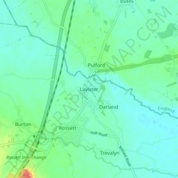
Name: Lavister topographic map, elevation, terrain.

Location: Lavister, Wrexham, Wales, LL12 0BF, United Kingdom (53.09834 -2.95688 53.13834 -2.91688)

Average elevation: 15 m

Minimum elevation: 4 m

Maximum elevation: 53 m

Wrexham trails, hiking, mountain biking, running and outdoor activities

Other topographic maps

Click on a map to view its topography, its elevation and its terrain.

Gwersyllt

United Kingdom > Wales > Wrexham

Average elevation: 112 m

Penycae

United Kingdom > Wales > Wrexham

Average elevation: 350 m

Rhosddu

United Kingdom > Wales > Wrexham

Average elevation: 88 m

Bangor-on-Dee

United Kingdom > Wales > Wrexham

Average elevation: 30 m

Cefn

United Kingdom > Wales > Wrexham > Acrefair

Average elevation: 142 m

Gear up for your next adventure:

🎒Hiking Daypacks (20L) - Compact backpacks for day trips and technical mountain ascents
🔦Waterproof LED Headlamps - Hands-free lighting for evening treks and emergency navigation
💧Hydration Reservoirs - Convenient water bladders for hands-free drinking on the move
🛌Sleeping Mats - Insulated mats for comfortable outdoor sleeping
🥾Men's Waterproof Hiking Boots - Durable footwear with deep lugs for muddy and rocky UK terrains

As an Amazon Associate, this site earns from qualifying purchases at no extra cost to you.