Geolocate

Newbridge topographic map

Click on the map to display elevation.

About this map

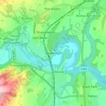
Name: Newbridge topographic map, elevation, terrain.

Location: Newbridge, Wrexham, Wales, LL14 3JQ, United Kingdom (52.94738 -3.08397 52.98738 -3.04397)

Average elevation: 117 m

Minimum elevation: 41 m

Maximum elevation: 314 m

Wrexham trails, hiking, mountain biking, running and outdoor activities

Other topographic maps

Click on a map to view its topography, its elevation and its terrain.

Gwersyllt

United Kingdom > Wales > Wrexham

Average elevation: 112 m

Penycae

United Kingdom > Wales > Wrexham

Average elevation: 350 m

Rhosddu

United Kingdom > Wales > Wrexham

Average elevation: 88 m

Bangor-on-Dee

United Kingdom > Wales > Wrexham

Average elevation: 30 m

Cefn

United Kingdom > Wales > Wrexham > Acrefair

Average elevation: 142 m

Gear up for your next adventure:

📱Rugged Phone Cases - Heavy-duty protection for smartphones used as secondary GPS tools
🔋Solar Power Banks - Keep your GPS and phone charged during multi-day expeditions
🔋Power Banks - Portable chargers for long outdoor trips
🔥Reusable Hand Warmers - Maintain dexterity in your fingers for precise map handling
🧣Neck Gaiters - Versatile protection against wind and cold

As an Amazon Associate, this site earns from qualifying purchases at no extra cost to you.