
West Bengal topographic map
Interactive map
Click on the map to display elevation.
About this map
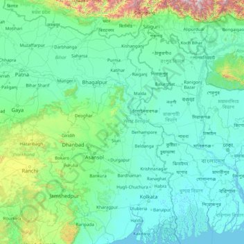
Name: West Bengal topographic map, elevation, terrain.
Location: West Bengal, India (21.54730 85.82009 27.22120 89.87254)
Average elevation: 182 m
Minimum elevation: -2 m
Maximum elevation: 4,084 m
The distribution of vegetation in northern West Bengal is dictated by elevation and precipitation. For example, the foothills of the Himalayas, the Dooars, are densely wooded with sal and other tropical evergreen trees. Above an elevation of 1,000 metres (3,300 ft), the forest becomes predominantly subtropical. In Darjeeling, which is above 1,500 metres (4,900 ft), temperate forest trees like oaks, conifers and rhododendrons predominate.
Other topographic maps
Click on a map to view its topography, its elevation and its terrain.
Bengaluru
India > Karnataka > Bangalore North
Bengaluru, Bangalore North, Bengaluru Urban District, Karnataka, India
Average elevation: 881 m
Chennai
India > Tamil Nadu > Chennai
Chennai, Chennai District, Tamil Nadu, India
Average elevation: 8 m
3d
India > Rajasthan > Ganganagar Tehsil > 1 LNP
3d, 1 LNP, Ganganagar Tehsil, Sri Ganganagar District, Rajasthan, India
Average elevation: 178 m
Kolkata
Kolkata, Kolkata District, West Bengal, 700073, India
Average elevation: 5 m
Lucknow
India > Uttar Pradesh > Lucknow
Lucknow, Lucknow District, Uttar Pradesh, 226027, India
Average elevation: 120 m
Pune
India > Maharashtra > Pune City > Pune
Pune, Pune City, Pune District, Maharashtra, 411001, India
Average elevation: 641 m
Pimpri-Chinchwad
India > Maharashtra > Haveli
Pimpri-Chinchwad, Haveli, Pune District, Maharashtra, 411089, India
Average elevation: 605 m
Mysuru
India > Karnataka > Mysuru taluk
Mysuru, Mysuru taluk, Mysuru District, Karnataka, 570001, India
Average elevation: 727 m
Western Ghats
Western Ghats, Idukki, Kerala, 685614, India
Average elevation: 2,225 m
Chhota Bhanuja
India > Rajasthan > Khamnor Tehsil
Chhota Bhanuja, Khamnor Tehsil, Rajsamand District, Rajasthan, 313321, India
Average elevation: 644 m
Chikodi taluk
Chikodi taluk, Belagavi District, Karnataka, India
Average elevation: 613 m
Narhe
India > Maharashtra > Bhor
Narhe, Bhor, Pune District, Maharashtra, India
Average elevation: 683 m
Nathdwara
India > Rajasthan > Nathdwara Tehsil
Nathdwara, Nathdwara Tehsil, Rajsamand District, Rajasthan, 313301, India
Average elevation: 590 m
Kukshi
India > Madhya Pradesh > Kukshi Tahsil > Kukshi
Kukshi, Kukshi Tahsil, Dhar District, Madhya Pradesh, 454331, India
Average elevation: 176 m
Thoothukudi
India > Tamil Nadu > Thoothukkudi
Thoothukudi, Thoothukkudi, Thoothukudi District, Tamil Nadu, 628001, India
Average elevation: 10 m
North Sentinel Island
India > Andaman and Nicobar Islands > Ferrargunj
North Sentinel Island, Ferrargunj, South Andaman District, Andaman and Nicobar Islands, India
Average elevation: 20 m
Bachupally mandal
Bachupally mandal, Medchal–Malkajgiri District, Telangana, 500090, India
Average elevation: 593 m
Gurgaon
India > Haryana > Gurugram District
Gurgaon, Gurugram District, Haryana, India
Average elevation: 237 m
Tehri-Garhwal
Tehri-Garhwal, Tehri Garhwal District, Uttarakhand, 249125, India
Average elevation: 2,339 m
Rampur Bushahr
India > Himachal Pradesh > Rampur
Rampur Bushahr, Rampur, Shimla district, Himachal Pradesh, India
Average elevation: 1,715 m
Thiruvananthapuram
India > Kerala > Thiruvananthapuram
Thiruvananthapuram, Thiruvananthapuram District, Kerala, 695001, India
Average elevation: 33 m