
Fujisawa topographic map
Interactive map
Click on the map to display elevation.
About this map
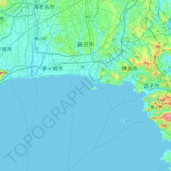
Name: Fujisawa topographic map, elevation, terrain.
Location: Fujisawa, Kanagawa Prefecture, Japan (35.17795 139.39398 35.42909 139.51685)
Average elevation: 17 m
Minimum elevation: -3 m
Maximum elevation: 205 m
Fujisawa has three major topographical features: the island of Enoshima to the south connected to the Katase shoreline area by a road bridge, and two rivers, the Hikiji and the Sakai, which run north-south. The Hikiji can be traced from an area designated as a nature reserve park in the city of Yamato and flows directly along the boundary of the joint US Navy and Japan Maritime Self-Defense Force Atsugi Naval Air Base and the United States Army Camp Zama. The Sakai runs directly from the mountains between Machida and Hachiōji, and for quite some distance forms the border between the Tokyo Metropolitan Area and Kanagawa Prefecture. From Machida city centre, the river can be directly followed by a foot and cycle path to Fujisawa city centre, a distance of approximately 35 km (22 mi). Another cycle path runs along the Shonan Coastal path, from the Sagami River, in Hiratsuka, to Enoshima Bridge in Fujisawa.
Other topographic maps
Click on a map to view its topography, its elevation and its terrain.
Mount Fuji
Japan > Sunto County > Oyama
Mount Fuji, Oyama, Sunto County, Shizuoka Prefecture, Chubu Region, Japan
Average elevation: 3,261 m
Ibaraki
Ibaraki, Higashiibaraki County, Ibaraki Prefecture, 311-3116, Japan
Average elevation: 26 m
Maborikaigan 4-chome Park
Maborikaigan 4-chome Park, Maboricho 3-chome, Yokosuka, Kanagawa Prefecture, 238-8550, Japan
Average elevation: 22 m
Lake Sanaru
Lake Sanaru, Hamamatsu, Shizuoka Prefecture, Chubu Region, Japan
Average elevation: 16 m
Motoyama
Motoyama, Nagaoka County, Kochi Prefecture, 781-3601, Japan
Average elevation: 679 m
Setouchi
Setouchi, Oshima County, Kagoshima Prefecture, Japan
Average elevation: 26 m
Higashishirakawa
Higashishirakawa, Kamo County, Gifu Prefecture, Chubu Region, 509-1392, Japan
Average elevation: 658 m
Nishikigaoka-chuo Park
Nishikigaoka-chuo Park, Nishikigaoka 2-chome, Aoba Ward, Sendai, Miyagi Prefecture, Japan
Average elevation: 197 m