
Bhagirathi River topographic map
Interactive map
Click on the map to display elevation.
Bhagirathi River
The Bhilangna itself rises at the foot of the Khatling Glacier (elevation 3,717 m (12,195 ft)) approximately 50 km (31 mi) south of Gaumukh.
About this map
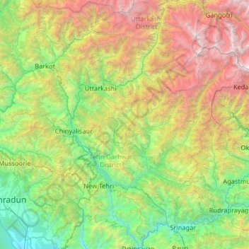
Name: Bhagirathi River topographic map, elevation, terrain.
Location: Bhagirathi River, Uttarakhand, India (30.14509 78.31487 31.04715 79.08187)
Average elevation: 2,256 m
Minimum elevation: 448 m
Maximum elevation: 6,889 m
Other topographic maps
Click on a map to view its topography, its elevation and its terrain.
Almora
India > Uttarakhand > Almora
Almora is located at 29°35′50″N 79°39′33″E / 29.5971°N 79.6591°E / 29.5971; 79.6591 in Almora district in Uttarakhand. Almora is situated 365 km north-east the national capital New Delhi and 415 km south-east the state capital Dehradun. It lies in the revenue Division Kumaon and is located…
Average elevation: 1,557 m
Gopeshwar
India > Uttarakhand > Chamoli Tehsil
Gopeshwar is located at 30°25′N 79°20′E / 30.42°N 79.33°E / 30.42; 79.33. It has an average elevation of 1,450 m (4,760 ft). Gopeshwar is 8.4 km (5.2 mi) away from Chamoli which is located on the banks of Alaknanda river and along NH 58. Gopeshwar is able to captivate any visitor with its…
Average elevation: 1,566 m
Tanakpur
India > Uttarakhand > Purnagiri
Tanakpur is located at 29°05′N 80°07′E / 29.08°N 80.12°E / 29.08; 80.12. It has an average elevation of 255 metres (837 feet).
Average elevation: 270 m
Gauchar
India > Uttarakhand > Karnaprayag
Gauchar (Garhwali: Gòchàr ) is a Hill Town sort of a valley town located in Karnaprayag tehsil within Chamoli district of Uttarakhand state in India. Gauchar is situated on the left bank of river Alaknanda and is en route to the celebrated holy destination of Badrinath. It is well known for being one of the…
Average elevation: 1,196 m
Haldwani
India > Uttarakhand > Haldwani
Haldwani is located at 29°13′N 79°31′E / 29.22°N 79.52°E / 29.22; 79.52, in the Nainital district on the right bank of the Gaula River. Geologically, Haldwani is settled on a piedmont grade (called Bhabhar) where the mountain rivers go underground to re-emerge in the Indo-Gangetic plain. The…
Average elevation: 673 m
Kathgodam
India > Uttarakhand > Haldwani
Kathgodam is located at 29°16′N 79°32′E / 29.27°N 79.53°E / 29.27; 79.53. It has an average elevation of 554 metres (1,483 feet). It is situated on the banks of the Gaula river.
Average elevation: 760 m