
Ashok Nagar topographic map
Interactive map
Click on the map to display elevation.
About this map
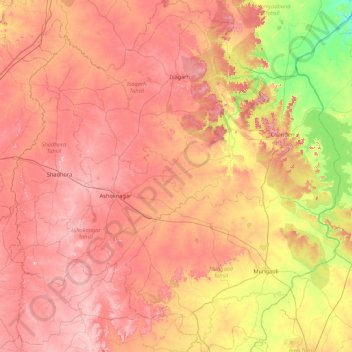
Name: Ashok Nagar topographic map, elevation, terrain.
Location: Ashok Nagar, Madhya Pradesh, India (24.22967 77.47284 25.00798 78.27808)
Average elevation: 447 m
Minimum elevation: 299 m
Maximum elevation: 565 m
Ashoknagar is situated at the average elevation of 507 metres(1640 ft) above sea level. It is in the plateau region. It has an agricultural topography. The plateau is an extension of the Deccan Traps, formed between 60 and 68 million years ago at the end of the Cretaceous period. In this region, the main classes of soil are black, brown and bhatori (stony) soil. The volcanic, clay-like soil of the region owes its black colour to the high iron content of the basalt from which it is formed. The soil requires less irrigation because of its high capacity for moisture retention. The other two soil types are lighter and have a higher proportion of sand. The year is popularly divided into three seasons: summer, the rains, and winter. Summer extends over the months of Chaitra to Jyestha (mid-March to mid-May). The average daily temperature during the summer months is 35 °C, which typically rises to around 46 °C on a few days. The rainy season starts with the first showers of Aashaadha (mid-June) and extends to the middle of Ashvin (September). Most of the rain falls during the southwest monsoon spell, and ranges from about 100 cm in the west to about 165 cm in the east. Ashoknagar and surrounding areas receive an average of 140 cm of rainfall a year. The growing period lasts from 90 to 150 days, during which the average daily temperature is below 30 °C, but seldom falls below 20 °C. Winter is the longest of the three seasons, extending for about five months (mid-Ashvin to Phalgun, i.e., October to mid-March). The average daily temperature ranges from 15 °C to 20 °C, though on some nights it can fall as low as 5 °C. Some cultivators believe that an occasional winter shower during the months of Pausha and Maagha—known as Mawta—is helpful to the early summer wheat and germ crops.
Other topographic maps
Click on a map to view its topography, its elevation and its terrain.
Indore
India > Madhya Pradesh > Juni Indore Tahsil
Indore, Juni Indore Tahsil, Indore District, Madhya Pradesh, 452001, India
Average elevation: 555 m
Kanchanpur
India > Madhya Pradesh > Karkeli Tahsil
Kanchanpur, Karkeli Tahsil, Umaria District, Madhya Pradesh, India
Average elevation: 500 m
Amlay
India > Madhya Pradesh > Shujalpur Tahsil
Amlay, Shujalpur Tahsil, Shajapur District, Madhya Pradesh, 465335, India
Average elevation: 467 m
Chhindwara
India > Madhya Pradesh > Chhindwara Tahsil
Chhindwara, Chhindwara Tahsil, Chhindwara District, Madhya Pradesh, 480001, India
Average elevation: 683 m
Buxwaha
India > Madhya Pradesh > Buxwaha Tahsil
Buxwaha, Buxwaha Tahsil, Chhatarpur District, Madhya Pradesh, India
Average elevation: 490 m
Gelana
India > Madhya Pradesh > Susner Tahsil > Gelana
Gelana, Susner Tahsil, Agar Malwa District, Madhya Pradesh, 465447, India
Average elevation: 404 m
Bhopal
India > Madhya Pradesh > Huzur Tahsil
Bhopal, Huzur Tahsil, Bhopal District, Madhya Pradesh, 462001, India
Average elevation: 498 m
Nowgaon
India > Madhya Pradesh > Nowgong Tahsil
Nowgaon, Nowgong Tahsil, Chhatarpur District, Madhya Pradesh, 471200, India
Average elevation: 233 m
Jaora
India > Madhya Pradesh > Jaora Tahsil
Jaora, Jaora Tahsil, Ratlam District, Madhya Pradesh, 457226, India
Average elevation: 472 m
Ratlam
India > Madhya Pradesh > Ratlam Nagar Tahsil
Ratlam, Ratlam Nagar Tahsil, Ratlam District, Madhya Pradesh, 457001, India
Average elevation: 485 m
Jawad
India > Madhya Pradesh > Jawad Tehsil > Jawad
Jawad, Jawad Tehsil, Neemuch District, Madhya Pradesh, 458330, India
Average elevation: 461 m
Neemuch
India > Madhya Pradesh > Neemuch Nagar Tehsil
Neemuch, Neemuch Nagar Tehsil, Neemuch District, Madhya Pradesh, 458411, India
Average elevation: 475 m
Manasa
India > Madhya Pradesh > Rawti Tahsil
Manasa, Rawti Tahsil, Ratlam District, Madhya Pradesh, India
Average elevation: 347 m
Jirapur
India > Madhya Pradesh > Shamshabad Tahsil > Jirapur
Jirapur, Shamshabad Tahsil, Vidisha District, Madhya Pradesh, India
Average elevation: 436 m
Pandhurna
India > Madhya Pradesh > Pandhurna Tahsil
Pandhurna, Pandhurna Tahsil, Pandhurna District, Madhya Pradesh, India
Average elevation: 485 m
Berasia
India > Madhya Pradesh > Berasia Tahsil
Berasia, Berasia Tahsil, Bhopal District, Madhya Pradesh, 463106, India
Average elevation: 478 m
Chanderi
India > Madhya Pradesh > Chanderi Tahsil
Chanderi, Chanderi Tahsil, Ashoknagar District, Madhya Pradesh, 473446, India
Average elevation: 440 m
Nalkheda
India > Madhya Pradesh > Jharda Tahsil > Nalkheda
Nalkheda, Jharda Tahsil, Ujjain District, Madhya Pradesh, 456441, India
Average elevation: 485 m
Narela
India > Madhya Pradesh > Sehore Tahsil
Narela, Sehore Tahsil, Sehore District, Madhya Pradesh, India
Average elevation: 494 m
Badnagar
India > Madhya Pradesh > Sehore Tahsil
Badnagar, Sehore Tahsil, Sehore District, Madhya Pradesh, India
Average elevation: 535 m
Ghatia
India > Madhya Pradesh > Teonthar Tahsil > Jhalari
Ghatia, Jhalari, Teonthar Tahsil, Rewa District, Madhya Pradesh, India
Average elevation: 133 m
Moman Barodiya
India > Madhya Pradesh > Momanbadodiya Tahsil > Mohan Badodiya
Moman Barodiya, Mohan Badodiya, Momanbadodiya Tahsil, Shajapur District, Madhya Pradesh, India
Average elevation: 449 m
Kalapipal
India > Madhya Pradesh > Jharda Tahsil > Kalapipal
Kalapipal, Jharda Tahsil, Ujjain District, Madhya Pradesh, India
Average elevation: 510 m
Khandwa
India > Madhya Pradesh > Khandwa Nagar Tahsil
Khandwa, Khandwa Nagar Tahsil, Khandwa District, Madhya Pradesh, 450001, India
Average elevation: 325 m
Sitamau
India > Madhya Pradesh > Sitamau Tahsil
Sitamau, Sitamau Tahsil, Mandsaur District, Madhya Pradesh, 458990, India
Average elevation: 465 m
Mandsaur
Mandsaur, Neemuch District, Madhya Pradesh, India
Average elevation: 439 m
Bhanpura
India > Madhya Pradesh > Bhanpura Tahsil
Bhanpura, Bhanpura Tahsil, Mandsaur District, Madhya Pradesh, 458775, India
Average elevation: 402 m
Niwari
India > Madhya Pradesh > Rehli Tahsil
Niwari, Rehli Tahsil, Sagar District, Madhya Pradesh, India
Average elevation: 396 m
Khilchipur
India > Madhya Pradesh > Khilchipur Tahsil > Khilchipur
Khilchipur, Khilchipur Tahsil, Rajgarh District, Madhya Pradesh, 465619, India
Average elevation: 400 m
Biaora
India > Madhya Pradesh > Ujjain Tahsil > Biaora
Biaora, Ujjain Tahsil, Ujjain District, Madhya Pradesh, India
Average elevation: 524 m
Sarangpur
India > Madhya Pradesh > Dhanora Tahsil
Sarangpur, Dhanora Tahsil, Seoni District, Madhya Pradesh, India
Average elevation: 580 m
Narsinghgarh
India > Madhya Pradesh > Bhind Tahsil > Narsinghgarh
Narsinghgarh, Bhind Tahsil, Bhind District, Madhya Pradesh, India
Average elevation: 150 m
Badnawar
India > Madhya Pradesh > Badnawar Tahsil
Badnawar, Badnawar Tahsil, Dhar District, Madhya Pradesh, India
Average elevation: 496 m
Khategaon
India > Madhya Pradesh > Khategaon Tahsil > Khategaon
Khategaon, Khategaon Tahsil, Dewas District, Madhya Pradesh, India
Average elevation: 297 m
Patharia
India > Madhya Pradesh > Gulana Tahsil > Muradpur Pathariya
Patharia, Muradpur Pathariya, Gulana Tahsil, Shajapur District, Madhya Pradesh, India
Average elevation: 453 m
Bijawar
India > Madhya Pradesh > Bijawar Tahsil
Bijawar, Bijawar Tahsil, Chhatarpur District, Madhya Pradesh, 471405, India
Average elevation: 369 m
Phanda
India > Madhya Pradesh > Huzur Tahsil
Phanda, Huzur Tahsil, Bhopal District, Madhya Pradesh, India
Average elevation: 521 m
Betul
India > Madhya Pradesh > Betul Tahsil
Betul, Betul Tahsil, Betul District, Madhya Pradesh, 460001, India
Average elevation: 635 m
Pansemal
India > Madhya Pradesh > Pansemal Tahsil
Pansemal, Pansemal Tahsil, Barwani District, Madhya Pradesh, India
Average elevation: 260 m
Kotma
India > Madhya Pradesh > Majhauli Tahsil
Kotma, Majhauli Tahsil, Sidhi District, Madhya Pradesh, India
Average elevation: 370 m
Badod
India > Madhya Pradesh > Badod Tahsil > Badod
Badod, Badod Tahsil, Agar Malwa District, Madhya Pradesh, 465550, India
Average elevation: 474 m
Dhar
India > Madhya Pradesh > Dhar Tahsil
Dhar, Dhar Tahsil, Dhar District, Madhya Pradesh, 454001, India
Average elevation: 557 m
Gunga
India > Madhya Pradesh > Berasia Tahsil
Gunga, Berasia Tahsil, Bhopal District, Madhya Pradesh, India
Average elevation: 498 m
Tikamgarh
India > Madhya Pradesh > Tikamgarh Tahsil
Tikamgarh, Tikamgarh Tahsil, Tikamgarh District, Madhya Pradesh, 472001, India
Average elevation: 349 m
Basi
India > Madhya Pradesh > Paraswada Tahsil
Basi, Paraswada Tahsil, Balaghat District, Madhya Pradesh, India
Average elevation: 594 m
Fatehpur Shamshi
India > Madhya Pradesh > Nateran Tahsil
Fatehpur Shamshi, Fatehpurshyaris, Nateran Tahsil, Vidisha District, Madhya Pradesh, India
Average elevation: 416 m
Sher
India > Madhya Pradesh > Gotegaon Tahsil
Sher, Gotegaon Tahsil, Narsinghpur District, Madhya Pradesh, India
Average elevation: 468 m
Garoth Tahsil
Garoth Tahsil, Mandsaur District, Madhya Pradesh, 458880, India
Average elevation: 420 m
Morda
India > Madhya Pradesh > Ratlam Tahsil > Morda
Morda, Ratlam Tahsil, Ratlam District, Madhya Pradesh, India
Average elevation: 472 m
Gujar Kheri
India > Madhya Pradesh > Nalkheda Tahsil > Gujarkhedi
Gujar Kheri, Gujarkhedi, Nalkheda Tahsil, Agar Malwa District, Madhya Pradesh, India
Average elevation: 389 m