
Make a donation
Gear up for your next adventure:
As an Amazon Associate, this site earns from qualifying purchases at no extra cost to you.
Ulaanbaatar topographic map
Click on the map to display elevation.
Make a donation
Gear up for your next adventure:
As an Amazon Associate, this site earns from qualifying purchases at no extra cost to you.
Ulaanbaatar
Ulaanbaatar, formerly anglicised as Ulan Bator /ˌuːlɑːn ˈbɑːtər/ (Mongolian: Улаанбаатар, , literally "Red Hero"), is the capital and largest city of Mongolia. The city is not part of any aimag (province), and its population as of 2014 was over 1.3 million, almost half of the country's population. The municipality is in north central Mongolia at an elevation of about 1,300 meters (4,300 ft) in a valley on the Tuul River. It is the country's cultural, industrial and financial heart, the centre of Mongolia's road network and connected by rail to both the Trans-Siberian Railway in Russia and the Chinese railway system.
Make a donation
Gear up for your next adventure:
As an Amazon Associate, this site earns from qualifying purchases at no extra cost to you.
About this map
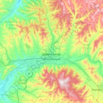
Name: Ulaanbaatar topographic map, elevation, terrain.
Location: Ulaanbaatar, Mongolia (47.73286 106.53455 48.14897 107.22004)
Average elevation: 1,554 m
Minimum elevation: 1,205 m
Maximum elevation: 2,260 m
Make a donation
Gear up for your next adventure:
As an Amazon Associate, this site earns from qualifying purchases at no extra cost to you.
Other topographic maps
Click on a map to view its topography, its elevation and its terrain.
Overlooking the steppe and sand dunes
Mongolia > Ömnögovi > Sevrey > Sevrey
Average elevation: 1,796 m
Make a donation
Gear up for your next adventure:
As an Amazon Associate, this site earns from qualifying purchases at no extra cost to you.
Отгонтэнгэр
Mongolia > Zavkhan > Aldarkhaan
Otgontenger (/ˌɒtɡɒnˈtɛŋɡər/; Mongolian: Отгонтэнгэр [ˈɔʰtχɞɴtʰɪŋɡɪ̆r]; lit. 'The Youngest Sky') is the highest peak in the Khangai Mountains in Mongolia. Its summit is currently calculated to reach an elevation of 4,010 meters above mean sea level (some earlier topographic…
Average elevation: 3,397 m
Make a donation
Gear up for your next adventure:
As an Amazon Associate, this site earns from qualifying purchases at no extra cost to you.
Choibalsan
Choibalsan (Mongolian: Чойбалсан) is the fourth-largest city in Mongolia after Ulaanbaatar, Darkhan, and Erdenet. The name of the city was Bayan Tümen (Баян Түмэн) until 1941, when it was renamed after the communist leader Khorloogiin Choibalsan in honor of the 20th anniversary of the…
Average elevation: 764 m
Make a donation
Gear up for your next adventure:
As an Amazon Associate, this site earns from qualifying purchases at no extra cost to you.
Make a donation
Gear up for your next adventure:
As an Amazon Associate, this site earns from qualifying purchases at no extra cost to you.
Make a donation
Gear up for your next adventure:
As an Amazon Associate, this site earns from qualifying purchases at no extra cost to you.
Make a donation
Gear up for your next adventure:
As an Amazon Associate, this site earns from qualifying purchases at no extra cost to you.
Make a donation
Gear up for your next adventure:
As an Amazon Associate, this site earns from qualifying purchases at no extra cost to you.
Make a donation
Gear up for your next adventure:
As an Amazon Associate, this site earns from qualifying purchases at no extra cost to you.
Make a donation
Gear up for your next adventure:
As an Amazon Associate, this site earns from qualifying purchases at no extra cost to you.
Make a donation
Gear up for your next adventure:
As an Amazon Associate, this site earns from qualifying purchases at no extra cost to you.
Ulaanbaatar
Mongolia > Ulaanbaatar > Ulaanbaatar
Ulaanbaatar (/ˌuːlɑːn ˈbɑːtər/; Mongolian: Улаанбаатар, , lit. "Red Hero"), previously anglicized as Ulan Bator, is the capital and most populous city of Mongolia. The municipality is located in north central Mongolia at an elevation of about 1,300 metres (4,300 ft) in a valley on the Tuul…
Average elevation: 1,541 m
Choir
Mongolia > Govisumber > Sumber
Choir lies in the Choir Depression, a lowland strip about 150 km long and 10 to 20 km wide, about 500 m lower than the surrounding upland. It lies at an altitude of 1269 m.
Average elevation: 1,282 m
Make a donation
Gear up for your next adventure:
As an Amazon Associate, this site earns from qualifying purchases at no extra cost to you.
Make a donation
Gear up for your next adventure:
As an Amazon Associate, this site earns from qualifying purchases at no extra cost to you.
Make a donation
Gear up for your next adventure:
As an Amazon Associate, this site earns from qualifying purchases at no extra cost to you.