
Kent topographic map
Interactive map
Click on the map to display elevation.
About this map
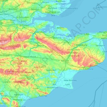
Name: Kent topographic map, elevation, terrain.
Location: Kent, England, United Kingdom (50.91048 0.03352 51.50368 1.45177)
Average elevation: 37 m
Minimum elevation: -3 m
Maximum elevation: 261 m
Kent was also the location of the largest number of art schools in the country during the nineteenth century, estimated by the art historian David Haste, to approach two hundred. This is believed to be the result of Kent being a front line county during the Napoleonic Wars. At this time, before the invention of photography, draughtsmen were used to draw maps and topographical representations of the fields of battle, and after the wars ended many of these settled permanently in the county in which they had been based. Once the idea of art schools had been established, even in small towns in Kent, the tradition continued, although most of the schools were very small one-man operations, each teaching a small number of daughters of the upper classes how to draw and make watercolour paintings. Nonetheless, some of these small art schools developed into much larger organisations, including Canterbury College of Art, founded by Thomas Sidney Cooper in 1868, which is today the University for the Creative Arts.
Other topographic maps
Click on a map to view its topography, its elevation and its terrain.
London
United Kingdom > England > London
London, Greater London, England, SW1A 2DX, United Kingdom
Average elevation: 42 m
Bristol
United Kingdom > England > City of Bristol
Bristol, City of Bristol, West of England, England, United Kingdom
Average elevation: 55 m
Liverpool
Liverpool, Liverpool City Region, England, United Kingdom
Average elevation: 26 m
City of London
United Kingdom > England > City of London > City of London
City of London, England, EC2V 5AE, United Kingdom
Average elevation: 42 m
Birmingham
Birmingham, West Midlands Combined Authority, England, United Kingdom
Average elevation: 138 m
Sheffield
Sheffield, South Yorkshire, England, United Kingdom
Average elevation: 168 m
London
London, Greater London, England, United Kingdom
Average elevation: 66 m
Greater Manchester
Greater Manchester, England, United Kingdom
Average elevation: 141 m
Woking
United Kingdom > England > Surrey
Woking, Surrey, England, United Kingdom
Average elevation: 38 m
Peak District National Park
United Kingdom > England > Derbyshire
Peak District National Park, Derbyshire, South Yorkshire, England, United Kingdom
Average elevation: 225 m
Winchester
United Kingdom > England > Hampshire
Winchester, Hampshire, England, United Kingdom
Average elevation: 73 m
East of England
East of England, England, United Kingdom
Average elevation: 39 m
Brighton
United Kingdom > England > Brighton and Hove
Brighton, Brighton and Hove, England, United Kingdom
Average elevation: 64 m
South East England
South East England, England, United Kingdom
Average elevation: 69 m
Lincolnshire
Lincolnshire, East Midlands, England, United Kingdom
Average elevation: 28 m
Cambridge
United Kingdom > England > Cambridge
Cambridge, Cambridgeshire, East of England, England, United Kingdom
Average elevation: 18 m
Telford
United Kingdom > England > Telford and Wrekin
Telford, Telford and Wrekin, England, TF3 4HB, United Kingdom
Average elevation: 136 m
Chesterfield
United Kingdom > England > Derbyshire
Chesterfield, Derbyshire, England, United Kingdom
Average elevation: 127 m
Southsea nudist beach
United Kingdom > England > Portsmouth
Southsea nudist beach, Eastney, Portsmouth, England, PO4 9LP, United Kingdom
Average elevation: 1 m
Bath
United Kingdom > England > Bath and North East Somerset
Bath, Bath and North East Somerset, West of England, England, United Kingdom
Average elevation: 100 m
Lake District National Park
Lake District National Park, England, United Kingdom
Average elevation: 206 m
Cambridgeshire
Cambridgeshire, Cambridgeshire and Peterborough, England, United Kingdom
Average elevation: 32 m
Hastings
United Kingdom > England > East Sussex
Hastings, East Sussex, England, United Kingdom
Average elevation: 36 m
Lincoln
United Kingdom > England > Lincolnshire
Lincoln, Lincolnshire, England, United Kingdom
Average elevation: 29 m
Bedford
United Kingdom > England > Bedford
Bedford, England, MK40 1SU, United Kingdom
Average elevation: 37 m
Plymouth
United Kingdom > England > Devon > Plymouth
Plymouth, Devon, South West England, England, PL1 1HH, United Kingdom
Average elevation: 81 m
Northamptonshire
Northamptonshire, England, United Kingdom
Average elevation: 97 m
Somerset
Somerset, South West England, England, United Kingdom
Average elevation: 87 m
Lancashire
Lancashire, North West England, England, United Kingdom
Average elevation: 153 m
Portsmouth
United Kingdom > England > Hampshire > Portsmouth
Portsmouth, Hampshire, South East England, England, PO1 5QH, United Kingdom
Average elevation: 28 m
Farnham
United Kingdom > England > Surrey > Waverley
Farnham, Waverley, Surrey, England, United Kingdom
Average elevation: 100 m
Guildford
United Kingdom > England > Surrey
Guildford, Surrey, England, United Kingdom
Average elevation: 74 m
Nottingham
United Kingdom > England > Nottinghamshire
Nottingham, England, United Kingdom
Average elevation: 56 m
Blandford Camp
United Kingdom > England > Dorset
Blandford Camp, Dorset, England, DT11 8RE, United Kingdom
Average elevation: 78 m
Buckinghamshire
United Kingdom > England > Buckinghamshire
Buckinghamshire, Greater London, England, United Kingdom
Average elevation: 103 m
West Yorkshire
West Yorkshire, England, United Kingdom
Average elevation: 172 m
Dorset
United Kingdom > England > Talbot Village
Dorset, Alder Road, Branksome, Talbot Village, Bournemouth, Christchurch and Poole, South West England, England, BH12 5BJ, United Kingdom
Average elevation: 57 m