
Make a donation
Gear up for your next adventure:
As an Amazon Associate, this site earns from qualifying purchases at no extra cost to you.
Großarl topographic map
Click on the map to display elevation.
Make a donation
Gear up for your next adventure:
As an Amazon Associate, this site earns from qualifying purchases at no extra cost to you.
About this map
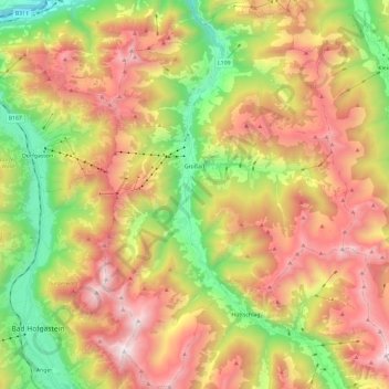
Name: Großarl topographic map, elevation, terrain.
Location: Großarl, Unterstein, Salzburg, 5611, Austria (47.14516 13.14574 47.30588 13.29921)
Average elevation: 1,491 m
Minimum elevation: 616 m
Maximum elevation: 2,445 m
Make a donation
Gear up for your next adventure:
As an Amazon Associate, this site earns from qualifying purchases at no extra cost to you.
Other topographic maps
Click on a map to view its topography, its elevation and its terrain.
Sankt Martin bei Lofer
Austria > Salzburg > Bezirk Zell am See > Gemeinde Sankt Martin bei Lofer
Average elevation: 913 m
Make a donation
Gear up for your next adventure:
As an Amazon Associate, this site earns from qualifying purchases at no extra cost to you.
Make a donation
Gear up for your next adventure:
As an Amazon Associate, this site earns from qualifying purchases at no extra cost to you.
Make a donation
Gear up for your next adventure:
As an Amazon Associate, this site earns from qualifying purchases at no extra cost to you.
Wallersee
Austria > Salzburg > Bezirk Salzburg-Umgebung > Seekirchen am Wallersee > Fischtaging
Average elevation: 531 m
Make a donation
Gear up for your next adventure:
As an Amazon Associate, this site earns from qualifying purchases at no extra cost to you.
Großvenediger
Austria > Salzburg > Bezirk Zell am See > Neukirchen am Großvenediger
Average elevation: 3,179 m
Make a donation
Gear up for your next adventure:
As an Amazon Associate, this site earns from qualifying purchases at no extra cost to you.
Großes Wiesbachhorn
Austria > Salzburg > Bezirk Zell am See > Fusch an der Großglocknerstraße
Average elevation: 2,879 m
Make a donation
Gear up for your next adventure:
As an Amazon Associate, this site earns from qualifying purchases at no extra cost to you.
Alpendorf Dachstein West
Austria > Salzburg > Bezirk Hallein > Annaberg-Lungötz > Annaberg im Lammertal
Average elevation: 1,047 m
Make a donation
Gear up for your next adventure:
As an Amazon Associate, this site earns from qualifying purchases at no extra cost to you.
Make a donation
Gear up for your next adventure:
As an Amazon Associate, this site earns from qualifying purchases at no extra cost to you.
Make a donation
Gear up for your next adventure:
As an Amazon Associate, this site earns from qualifying purchases at no extra cost to you.
Make a donation
Gear up for your next adventure:
As an Amazon Associate, this site earns from qualifying purchases at no extra cost to you.
Alpendorf
Austria > Salzburg > Bezirk St. Johann im Pongau > Sankt Johann im Pongau
Alpendorf (German for alpine village) is a village and a part of the town St. Johann im Pongau. It is 55 km (34 mi) south of the Austrian city of Salzburg. It is at an altitude of 850 m (2,790 ft) above sea level.
Average elevation: 880 m
Make a donation
Gear up for your next adventure:
As an Amazon Associate, this site earns from qualifying purchases at no extra cost to you.
Hohlwegen
Austria > Salzburg > Bezirk Zell am See > Saalfelden am Steinernen Meer
Average elevation: 1,106 m
Schmalenbergham
Austria > Salzburg > Bezirk Zell am See > Saalfelden am Steinernen Meer > Thor
Average elevation: 784 m
Make a donation
Gear up for your next adventure:
As an Amazon Associate, this site earns from qualifying purchases at no extra cost to you.
Königsleiten
Austria > Salzburg > Bezirk Zell am See > Gemeinde Wald im Pinzgau
Average elevation: 1,703 m
Make a donation
Gear up for your next adventure:
As an Amazon Associate, this site earns from qualifying purchases at no extra cost to you.
Make a donation
Gear up for your next adventure:
As an Amazon Associate, this site earns from qualifying purchases at no extra cost to you.
Make a donation
Gear up for your next adventure:
As an Amazon Associate, this site earns from qualifying purchases at no extra cost to you.
Zauchensee
Austria > Salzburg > Bezirk St. Johann im Pongau > Altenmarkt im Pongau
Average elevation: 1,696 m
Wald im Pinzgau
Austria > Salzburg > Bezirk Zell am See > Gemeinde Wald im Pinzgau
Average elevation: 1,163 m
Make a donation
Gear up for your next adventure:
As an Amazon Associate, this site earns from qualifying purchases at no extra cost to you.
Obersulzbachkees
Austria > Salzburg > Bezirk Zell am See > Marktgemeinde Neukirchen am Großvenediger
Average elevation: 2,757 m
Rohrmoos
Austria > Salzburg > Bezirk St. Johann im Pongau > Mühlbach am Hochkönig
Average elevation: 1,103 m