
Make a donation
Gear up for your next adventure:
As an Amazon Associate, this site earns from qualifying purchases at no extra cost to you.
Dowa topographic map
Click on the map to display elevation.
Make a donation
Gear up for your next adventure:
As an Amazon Associate, this site earns from qualifying purchases at no extra cost to you.
About this map
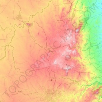
Name: Dowa topographic map, elevation, terrain.
Location: Dowa, Central Region, Malawi, Malawi (-13.84734 33.40671 -13.23042 34.30338)
Average elevation: 1,088 m
Minimum elevation: 516 m
Maximum elevation: 1,687 m
Make a donation
Gear up for your next adventure:
As an Amazon Associate, this site earns from qualifying purchases at no extra cost to you.
Other topographic maps
Click on a map to view its topography, its elevation and its terrain.
Blantyre
From 1876 to 1905, urban development in Blantyre was confined to three distinct areas within 2 km of each other: Blantyre Mission, Mandala (European commercial venture), and the government zone and commercial centre triangle marked by Haile Selassie Road, Glyn Jones Road and Hannover Street. In Limbe…
Average elevation: 872 m
Make a donation
Gear up for your next adventure:
As an Amazon Associate, this site earns from qualifying purchases at no extra cost to you.
Make a donation
Gear up for your next adventure:
As an Amazon Associate, this site earns from qualifying purchases at no extra cost to you.
Make a donation
Gear up for your next adventure:
As an Amazon Associate, this site earns from qualifying purchases at no extra cost to you.
Make a donation
Gear up for your next adventure:
As an Amazon Associate, this site earns from qualifying purchases at no extra cost to you.
Blantyre
From 1876 to 1905, urban development in Blantyre was confined to three distinct areas within 2 km of each other: Blantyre Mission, Mandala (European commercial venture), and the government zone and commercial centre triangle marked by Haile Selassie Road, Glyn Jones Road and Hannover Street. In Limbe…
Average elevation: 872 m
Make a donation
Gear up for your next adventure:
As an Amazon Associate, this site earns from qualifying purchases at no extra cost to you.
Kasungu National Park
Kasungu National Park, established in 1970, is the second-largest in Malawi at 2,316 square kilometres (894 sq mi), with an elevation of approximately 1,000 metres (3,300 ft) above sea level on average. It is located in the Central Region approximately 165 km (103 mi) north of Lilongwe.
Average elevation: 1,087 m
Make a donation
Gear up for your next adventure:
As an Amazon Associate, this site earns from qualifying purchases at no extra cost to you.
Make a donation
Gear up for your next adventure:
As an Amazon Associate, this site earns from qualifying purchases at no extra cost to you.
Make a donation
Gear up for your next adventure:
As an Amazon Associate, this site earns from qualifying purchases at no extra cost to you.
Make a donation
Gear up for your next adventure:
As an Amazon Associate, this site earns from qualifying purchases at no extra cost to you.
Make a donation
Gear up for your next adventure:
As an Amazon Associate, this site earns from qualifying purchases at no extra cost to you.