
Kampung Bohor topographic map
Interactive map
Click on the map to display elevation.
About this map
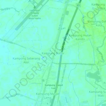
Name: Kampung Bohor topographic map, elevation, terrain.
Location: Kampung Bohor, Kota Setar, Kedah, 05350, Malaysia (6.15196 100.38420 6.19196 100.42420)
Average elevation: 4 m
Minimum elevation: 0 m
Maximum elevation: 10 m
Other topographic maps
Click on a map to view its topography, its elevation and its terrain.
Kampung Baru Bagan Samak
Malaysia > Kedah > Permatang Kerat Telunjuk > Kampung Baru Bagan Samak
Average elevation: 3 m
Kemajuan Tanah (FELDA) Lubok Merbau
Malaysia > Kedah > Kemajuan Tanah (FELDA) Lubok Merbau
Average elevation: 60 m