
South Carolina topographic map
Interactive map
Click on the map to display elevation.
South Carolina
South Carolina's topography is defined by three major geographic regions: the Atlantic Coastal Plain, the Piedmont, and the Blue Ridge Mountains. Covering approximately two-thirds of the state, the Atlantic Coastal Plain is characterized by flat, gently rolling terrain that transitions from the sandy beaches along the Atlantic Ocean to swamps and estuaries further inland. The coastal areas are interspersed with barrier islands and unique features like Carolina bays—elliptical depressions formed by various geological processes. Moving inland, the Piedmont region features rolling hills and elevated plateaus, with elevations generally ranging from 400 to 1,200 feet (122 to 366 meters), and includes the distinctive fall line where the rivers descend to the lower coastal plain. The northwest corner of the state rises into the Blue Ridge Mountains, with Sassafras Mountain as the highest point at 3,560 feet (1,085 meters). This area is known for its rugged terrain, steep slopes, and rich biodiversity. Overall, South Carolina's diverse topography reflects a rich geological history influenced by ancient mountains, river systems, and coastal dynamics.
About this map
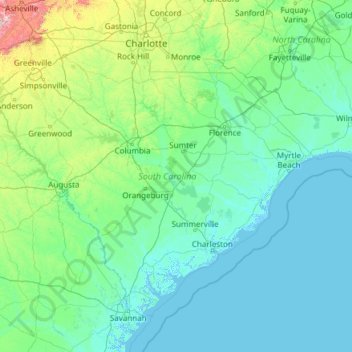
Name: South Carolina topographic map, elevation, terrain.
Location: South Carolina, United States (32.03345 -83.35400 35.21549 -78.54135)
Average elevation: 85 m
Minimum elevation: -4 m
Maximum elevation: 1,642 m
Other topographic maps
Click on a map to view its topography, its elevation and its terrain.
Appalachian Mountains
United States > North Carolina > Yancey County
The Appalachian Mountains (French: Appalaches), often called the Appalachians, are a system of mountains in eastern to northeastern North America. The Appalachians first formed roughly 480 million years ago during the Ordovician Period. They once reached elevations similar to those of the Alps and the Rocky…
Average elevation: 1,463 m
Virginia Beach
United States > Virginia > Virginia Beach
According to the United States Census Bureau, the city has a total area of 497 square miles (1,290 km2), of which 249 square miles (640 km2) is land and 248 square miles (640 km2) (49.9%) is water. It is the largest city in Virginia by total area and third-largest city land area. The average elevation is 12…
Average elevation: 2 m
San Francisco Bay Area
United States > California > San Francisco
The San Francisco Bay Area is characterized by a diverse and dynamic topography shaped by geological processes over millions of years. This region features a combination of coastal plains, steep hills, and rugged mountains, all influenced by the tectonic activity associated with the nearby San Andreas Fault…
Average elevation: 113 m
Santa Cruz Mountains
United States > California > Santa Clara County
The Santa Cruz Mountains are a region of great biological diversity, encompassing cool, moist coastal ecosystems as well as warm, dry chaparral. Much of the area in the Santa Cruz mountains is considered temperate rainforest. In valleys and moist ocean-facing slopes some of the southernmost coast redwoods…
Average elevation: 230 m
Appalachian Mountains
United States > North Carolina > Yancey County
The Appalachian Mountains (French: Appalaches), often called the Appalachians, are a system of mountains in eastern to northeastern North America. The Appalachians first formed roughly 480 million years ago during the Ordovician Period. They once reached elevations similar to those of the Alps and the Rocky…
Average elevation: 1,463 m
Rocky Mountains
United States > Wyoming > Teton County
Agriculture and forestry are major industries. Agriculture includes dryland and irrigated farming and livestock grazing. Livestock are frequently moved between high-elevation summer pastures and low-elevation winter pastures, a practice known as transhumance.
Average elevation: 2,292 m
Mount Washington
United States > New Hampshire > Coos County
Mount Washington, also known as Agiocochook, is an ultra-prominent mountain in the state of New Hampshire. It is the highest peak in the Northeastern United States at 6,288.2 ft (1,916.6 m) and the most topographically prominent mountain east of the Mississippi River.
Average elevation: 1,568 m
Ponte Vedra Beach
United States > Florida > Saint Johns County > Ponte Vedra Beach
Ponte Vedra Beach is characterized by its gently rolling terrain that is primarily flat and lies only about 15 feet above sea level. The landscape is predominantly shaped by coastal dunes and the proximity to the Atlantic Ocean, resulting in sandy beaches interspersed with vegetation typical of barrier island…
Average elevation: 3 m
Mount Hood
United States > Oregon > Hood River County
Timberline Lodge is a National Historic Landmark located on the southern flank of Mount Hood just below Palmer Glacier, with an elevation of about 6,000 ft (1,800 m).
Average elevation: 2,716 m
Central Park
United States > New York > New York County > New York
In June 1856, Fernando Wood appointed a "consulting board" of seven people, headed by author Washington Irving, to inspire public confidence in the proposed development. Wood hired military engineer Egbert Ludovicus Viele as the park's chief engineer, tasking him with a topographical survey of the site. The…
Average elevation: 26 m
Peter's Rock
United States > Connecticut > South Central Connecticut Planning Region > North Haven
Average elevation: 38 m
San Jacinto Mountains
United States > California > Riverside County
The San Jacinto Mountains, like the neighboring San Bernardino Mountains, are a humid island above the surrounding desert and semi-desert. Annual precipitation ranges from about 15 inches at the western base (and only 6 inches on the eastern, desert base) to as much as 32 inches above 5,500 feet (the mountain…
Average elevation: 2,687 m
Rydal Park
United States > Pennsylvania > Montgomery County > Abington Township
Average elevation: 87 m
Columbus
United States > Ohio > Franklin County > Columbus
The confluence of the Scioto and Olentangy rivers is just north-west of Downtown Columbus. Several smaller tributaries course through the Columbus metropolitan area, including Alum Creek, Big Walnut Creek, and Darby Creek. Columbus is considered to have relatively flat topography thanks to a large glacier that…
Average elevation: 255 m
San Diego
United States > California > San Diego County > San Diego
The climate in San Diego, like most of Southern California, often varies significantly over short geographical distances, resulting in microclimates. In San Diego, this is mostly because of the city's topography (the Bay, and the numerous hills, mountains, and canyons). Frequently, particularly during the "May…
Average elevation: 57 m
Atlanta
United States > Georgia > Fulton County
Atlanta (/ætˈlæntə/ at-LAN-tə) is the capital and most populous city of the U.S. state of Georgia. It is the seat of Fulton County, the most populous county in Georgia. With a population of 498,715 living within the city limits, it is the eighth most populous city in the Southeast and 38th most populous…
Average elevation: 285 m
Plumsteadville
United States > Pennsylvania > Bucks County > Plumstead Township
Average elevation: 160 m
Port Charlotte
United States > Florida > Charlotte County
Port Charlotte is characterized by a predominantly flat and low-lying terrain, typical of Florida’s coastal landscape. The area features a network of waterways, including the Peace River and Charlotte Harbor, which provide ample opportunities for recreational activities like boating and fishing. Elevations…
Average elevation: 4 m
Golden Gate Park
United States > California > San Francisco
In the 1860s, San Franciscans began to feel the need for a spacious public park similar to Central Park, which was then taking shape in New York City. Golden Gate Park was carved out of unpromising sand and shore dunes that were known as the Outside Lands, in an unincorporated area west of San Francisco's…
Average elevation: 71 m
Estes Park
United States > Colorado > Larimer County
Estes Park sits at an elevation of 7,522 feet (2,293 m) on the front range of the Rocky Mountains at the eastern entrance of the Rocky Mountain National Park. Its north, south and east extremities border the Roosevelt National Forest. Lumpy Ridge lies immediately north of Estes Park.
Average elevation: 2,543 m
Oakhurst
United States > California > Madera County > Oakhurst
Oakhurst is located on the Fresno River 3 miles (5 km) south-southwest of Yosemite Forks, at an elevation of 2,274 feet (693 m). Its coordinates are 37°19′41″N 119°38′58″W / 37.32806°N 119.64944°W / 37.32806; -119.64944. It is located at the junction of state highways 41 and 49, at the…
Average elevation: 837 m
Baltimore
United States > Maryland > Baltimore
Baltimore is in north-central Maryland on the Patapsco River close to where it empties into the Chesapeake Bay. The city is also located on the fall line between the Piedmont Plateau and the Atlantic coastal plain, which divides Baltimore into "lower city" and "upper city". The city's elevation ranges from sea…
Average elevation: 65 m
Evergreen
United States > Colorado > Jefferson County
Evergreen sits at an elevation of 7,220 feet (2,200 m) in the Rocky Mountains, 19 miles west of Denver, Colorado. Its addresses are oriented according to the Street_system_of_Denver.
Average elevation: 2,309 m
Five Points
United States > Connecticut > Western Connecticut Planning Region > Redding Ridge
Average elevation: 185 m
Dominguez-Velez de Escalente Trail Historical Marker
United States > New Mexico > Rio Arriba County > Abiquiu > El Curuco
Average elevation: 1,877 m
Hanaway Covered Bridge Park
United States > Ohio > Fairfield County > Clearport
Average elevation: 273 m
Loyalsockville
United States > Pennsylvania > Lycoming County > Upper Fairfield Township
Average elevation: 262 m
Rio Grande Rift Historical Marker
United States > New Mexico > Cibola County > Laguna
Average elevation: 1,782 m
Rum River North County Park
United States > Minnesota > Anoka County > Saint Francis
Average elevation: 279 m
Anchor Bay Shores
United States > Michigan > Macomb County > Chesterfield Township
Average elevation: 176 m
Canoe Creek
United States > Pennsylvania > Blair County > Frankstown Township
Average elevation: 347 m
Spencer Lake
United States > Minnesota > Meeker County > Collinwood Township > Jennie
Average elevation: 334 m
Flattop Mountain
United States > Alaska > Anchorage
It is usually reached by driving to the Glen Alps trailhead and following a 1.5-mile (2.4-km) trail, with an elevation gain of 1,280 feet (390 m) from the parking lot to the plateau. Off the plateau loop is a difficult trail to the peak. Since it is the most accessible mountain to Anchorage, Flattop is a very…
Average elevation: 735 m
Drakeville
United States > Connecticut > Northwest Hills Planning Region > Torrington
Average elevation: 309 m