
Pulau Bali topographic map
Interactive map
Click on the map to display elevation.
Pulau Bali
Bali's central mountains include several peaks over 2,000 metres (6,600 feet) in elevation and active volcanoes such as Mount Batur. The highest is Mount Agung (3,031 m, 9,944 ft), known as the "mother mountain", which is an active volcano rated as one of the world's most likely sites for a massive eruption within the next 100 years. In late 2017 Mount Agung started erupting and large numbers of people were evacuated, temporarily closing the island's airport. Mountains range from centre to the eastern side, with Mount Agung the easternmost peak. Bali's volcanic nature has contributed to its exceptional fertility and its tall mountain ranges provide the high rainfall that supports the highly productive agriculture sector. South of the mountains is a broad, steadily descending area where most of Bali's large rice crop is grown. The northern side of the mountains slopes more steeply to the sea and is the main coffee-producing area of the island, along with rice, vegetables, and cattle. The longest river, Ayung River, flows approximately 75 km (47 mi) (see List of rivers of Bali).
About this map
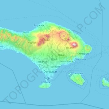
Name: Pulau Bali topographic map, elevation, terrain.
Location: Pulau Bali, Bali, Lesser Sunda Islands, Indonesia (-8.85043 114.43162 -8.06159 115.71150)
Average elevation: 122 m
Minimum elevation: -1 m
Maximum elevation: 2,917 m
Other topographic maps
Click on a map to view its topography, its elevation and its terrain.
Bali Island
Bali's central mountains include several peaks over 2,000 metres (6,600 feet) in elevation and active volcanoes such as Mount Batur. The highest is Mount Agung (3,031 m; 9,944 ft), known as the "mother mountain", which is an active volcano rated as one of the world's most likely sites for a massive eruption…
Average elevation: 357 m
Mount Agung
Indonesia > Bali > Karangasem
Australia's Bureau of Meteorology reported on 27 November that ash from the eruption had been observed at an altitude of 9,144 m. By the beginning of December, the eruption reduced to minor emissions of steam and smoke. On 12 December, a picture of the crater was taken showing a steadily growing lava dome…
Average elevation: 2,534 m
Denpasar
Indonesia > Bali > Dangin Puri
Denpasar is located at an elevation of 4 m (13 ft) above sea level. While the total area of 125.98 km2 or 2.18% of the total area of Bali Province. From the use of land, 2,768 hectares of land are paddy, 10,001 hectares are dry land, while the remaining land area is 9 hectares.
Average elevation: 48 m