
Kampung Matahari Naik topographic map
Interactive map
Click on the map to display elevation.
About this map
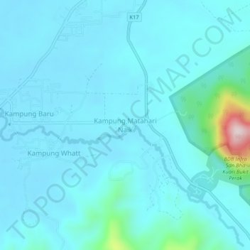
Name: Kampung Matahari Naik topographic map, elevation, terrain.
Location: Kampung Matahari Naik, Pendang, Kedah, Malaysia (5.94477 100.57365 5.98477 100.61365)
Average elevation: 70 m
Minimum elevation: 24 m
Maximum elevation: 481 m
Other topographic maps
Click on a map to view its topography, its elevation and its terrain.
Kampung Baru Bagan Samak
Malaysia > Kedah > Permatang Kerat Telunjuk > Kampung Baru Bagan Samak
Average elevation: 3 m
Kemajuan Tanah (FELDA) Lubok Merbau
Malaysia > Kedah > Kemajuan Tanah (FELDA) Lubok Merbau
Average elevation: 60 m