
Yabu topographic map
Interactive map
Click on the map to display elevation.
About this map
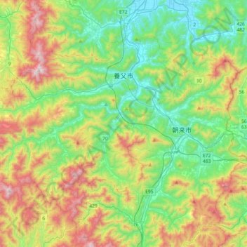
Name: Yabu topographic map, elevation, terrain.
Location: Yabu, Hyogo Prefecture, Japan (35.24165 134.50287 35.45185 134.86293)
Average elevation: 371 m
Minimum elevation: 1 m
Maximum elevation: 1,115 m
Yabu is located in the northern part of Hyōgo Prefecture and the Kinki region.The Maruyama River flows from the southeast to the northeast in the eastern part of the city, and the Yoka and Sekinomiya neighborhoods are located along the Yagi River, which is a tributary of the Maruyama River, and the Yabu and Oya areas are located along the Oya River. Part of the city is within the borders of the Hyōnosen-Ushiroyama-Nagisan Quasi-National Park, including Mount Myōken (1139 meters), and Mount Hyōno the city's highest elevation at 1510 meters.
Other topographic maps
Click on a map to view its topography, its elevation and its terrain.
Mount Fuji
Japan > Sunto County > Oyama
Mount Fuji, Oyama, Sunto County, Shizuoka Prefecture, Chubu Region, Japan
Average elevation: 3,261 m
Ibaraki
Ibaraki, Higashiibaraki County, Ibaraki Prefecture, 311-3116, Japan
Average elevation: 26 m
Maborikaigan 4-chome Park
Maborikaigan 4-chome Park, Maboricho 3-chome, Yokosuka, Kanagawa Prefecture, 238-8550, Japan
Average elevation: 22 m
Lake Sanaru
Lake Sanaru, Hamamatsu, Shizuoka Prefecture, Chubu Region, Japan
Average elevation: 16 m
Motoyama
Motoyama, Nagaoka County, Kochi Prefecture, 781-3601, Japan
Average elevation: 679 m
Setouchi
Setouchi, Oshima County, Kagoshima Prefecture, Japan
Average elevation: 26 m
Higashishirakawa
Higashishirakawa, Kamo County, Gifu Prefecture, Chubu Region, 509-1392, Japan
Average elevation: 658 m
Nishikigaoka-chuo Park
Nishikigaoka-chuo Park, Nishikigaoka 2-chome, Aoba Ward, Sendai, Miyagi Prefecture, Japan
Average elevation: 197 m