
焦作市 topographic map
Interactive map
Click on the map to display elevation.
About this map
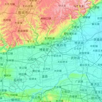
Name: 焦作市 topographic map, elevation, terrain.
Location: 焦作市, 河南省, 中国 (34.81343 112.56276 35.49417 113.64445)
Average elevation: 347 m
Minimum elevation: 75 m
Maximum elevation: 1,609 m
焦作市北依太行与山西省接壤,南临黄河与郑州、洛阳相望,地理坐标北纬35º10′- 35º21′,东经113º4′-113º26′之间,辖区东西长约32.5公里,南北宽约19.7公里。地貌由低山、丘陵、坡岗、平原四个部分组成,海拔在85-940米之间,地势高度由西北向东南递减。
Other topographic maps
Click on a map to view its topography, its elevation and its terrain.