
Samegrelo-Upper Svaneti topographic map
Interactive map
Click on the map to display elevation.
About this map
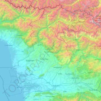
Name: Samegrelo-Upper Svaneti topographic map, elevation, terrain.
Location: Samegrelo-Upper Svaneti, Georgia (42.01441 41.29024 43.25698 43.14623)
Average elevation: 1,104 m
Minimum elevation: -2 m
Maximum elevation: 5,127 m
Other topographic maps
Click on a map to view its topography, its elevation and its terrain.
Caucasus Mountains
Georgia > Mtskheta-Mtianeti > Dusheti Municipality > Chalisopeli
The climate of the Caucasus varies both vertically (according to elevation) and horizontally (by latitude and location). Temperature generally decreases as elevation rises. Average annual temperature in Sukhumi, Abkhazia at sea level is 15 °C (59 °F) while on the slopes of Mt.Kazbek at an elevation of 3,700…
Average elevation: 2,188 m
Shan
Georgia > Mtskheta-Mtianeti > Kazbegi Municipality
Mt. Shani (Ingush: Шанлоам, lit. ''icy mountain''; Georgian: შანი; Russian: Шан) also known as Shan and Shanloam is a mountain in the Caucasus. It has an elevation of 4,451 metres (14,603 ft) and is on the international border between Georgia and Ingushetia, Russia.
Average elevation: 3,620 m
Tbilisa Glacier
Georgia > Racha-Lechkhumi and Kvemo Svaneti > Oni Municipality
Average elevation: 3,443 m
Makhuntseti waterfall
Georgia > Autonomous Republic of Adjara > Keda Municipality > Zeda Makhuntseti
Average elevation: 354 m
Mirveti Waterfall
Georgia > Autonomous Republic of Adjara > Khelvachauri Municipality > Mirveti
Average elevation: 297 m
Merisi waterfall
Georgia > Autonomous Republic of Adjara > Keda Municipality > Gundauri
Average elevation: 902 m
Cold Waterfall
Georgia > Autonomous Republic of Adjara > Khelvachauri Municipality > Sarpi
Average elevation: 101 m
Shemokmedi
Georgia > Guria > Ozurgeti Municipality
Shemokmedi (Georgian: შემოქმედი) is a village in the Ozurgeti Municipality, Guria, Georgia. It is located in western Georgia, on the Bzhuzhi river, at elevation of 190 m above sea level, 7 km east of the city of Ozurgeti. The village is home to the late medieval Shemokmedi Monastery.
Average elevation: 181 m
Nokalakevi (Tsikhegoji)
Georgia > Samegrelo-Upper Svaneti > Senaki Municipality > Gakhomela
Average elevation: 158 m
Twin Waterfalls
Georgia > Autonomous Republic of Adjara > Khelvachauri Municipality
Average elevation: 1,079 m
Buba Glacier
Georgia > Racha-Lechkhumi and Kvemo Svaneti > Oni Municipality
Average elevation: 3,398 m
Waterfall at Stone Mining
Georgia > Autonomous Republic of Adjara > Kobuleti Municipality
Average elevation: 484 m
Gudauri
Georgia > Mtskheta-Mtianeti > Kazbegi Municipality
Gudauri (Georgian: გუდაური) is a ski resort located on the south-facing plateau of The Greater Caucasus Mountain Range in Georgia. The resort is situated in the Stepantsminda District, along the Georgian Military Highway near the Jvari Pass, at an elevation of 2,200 meters (7,200 ft.) above sea…
Average elevation: 2,161 m
Nokalakevi (Tsikhegoji)
Georgia > Samegrelo-Upper Svaneti > Senaki Municipality > Gakhomela
Average elevation: 158 m
Murmaneti
Georgia > Autonomous Republic of Adjara > Khelvachauri Municipality
Average elevation: 153 m
Shaori Reservoir
Georgia > Racha-Lechkhumi and Kvemo Svaneti > Ambrolauri Municipality > Kharistvala
Average elevation: 1,281 m
Tbilisi
Most of the raions are named after historic quarters of the city. The citizens of Tbilisi widely recognise an informal system of smaller historic neighbourhoods. Such neighbourhoods are several, however, constituting a kind of hierarchy, because most of them have lost their distinctive topographic limits. The…
Average elevation: 713 m