
Escondido topographic map
Interactive map
Click on the map to display elevation.
Escondido
Escondido has a borderline semi-arid climate (Köppen: Bsh) and hot-summer Mediterranean climate (Köppen: Csa) with hot summers and cool, wet winters. Owing to its inland setting, it is considerably warmer than coastal cities like San Diego, Carlsbad or Oceanside during the summertime, and cooler in the winter. Yearly precipitation averages around 15 inches (380 mm) and can vary considerably from year to year. Rainfall totals are higher in the hills to the north and east, with 20–24 inches (510–610 mm) falling in most areas above 2,000 feet (610 m) in elevation, and over 30 inches (760 mm) on Palomar Mountain, 15 miles (24 km) to the east. More than 80% of all precipitation takes place from November through March. Snow is virtually unheard of, though occasionally winter and springtime thunderstorms will drop small hail. The climate is mild enough to allow widespread cultivation of avocados and oranges. Escondido is located in a plant hardiness zone 10a. The hottest temperature recorded in Escondido was 115 °F (46 °C) on September 6, 2020. The coldest temperature recorded in Escondido was 13 °F (−11 °C) on January 2, 1901, and January 7, 1913.
About this map
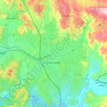
Name: Escondido topographic map, elevation, terrain.
Location: Escondido, California, United States (33.05766 -117.14612 33.21162 -116.99388)
Average elevation: 273 m
Minimum elevation: 87 m
Maximum elevation: 703 m
Other topographic maps
Click on a map to view its topography, its elevation and its terrain.
Malibu
The Malibu Coast lies on the fringe of an extensive chaparral and woodland wilderness area, the Santa Monica Mountains National Recreation Area. Various environmental elements collectively create a recipe for natural disasters: the mountainous and geologically unstable terrain; seasonal rainstorms that result…
Average elevation: 144 m
Yosemite National Park
The geology of the Yosemite area is characterized by granite rocks and remnants of older rock. About 10 million years ago, the Sierra Nevada was uplifted and tilted to form its unique slopes, which increased the steepness of stream and river beds, resulting in the formation of deep, narrow canyons. About one…
Average elevation: 2,337 m
Folsom
United States > California > Sacramento County
Carpenter Hill in Folsom has the highest elevation in Sacramento County.
Average elevation: 92 m
Humboldt County
The coastal zone of the county experiences very wet, cool winters and dry, mild foggy summers. In the winter, temperatures range from highs of 40–59 °F (4–15 °C) to lows of 32–49 °F (0–9 °C). Coastal summers are cool to mild, with average highs of 60–69 °F (16–21 °C) and frequent fogs.…
Average elevation: 540 m
Palm Springs
United States > California > Riverside County
One possible origin of palm in the place name comes from early Spanish explorers who referred to the area as La Palma de la Mano de Dios or "The Palm of God's hand". The earliest use of the name "Palm Springs" is from United States Topographical Engineers who used the term in 1853 maps. According to William…
Average elevation: 859 m
Sonoma County
Sonoma County, as is often the case with coastal counties in California, has a great degree of climatic variation and numerous, often very different, microclimates. Key determining factors for local climate are proximity to the ocean, elevation, and the presence and elevation of hills or mountains to the east…
Average elevation: 210 m
Santa Barbara
United States > California > Santa Barbara County
Annual rainfall totals are highly variable and in exceptional years like 1940–1941 and 1997–1998 over 40 inches (1.0 m) of rain have fallen in a year, but in dry seasons less than 6 inches (150 mm) is not unheard of. Snow sometimes covers higher elevations of the Santa Ynez Mountains but is extremely rare…
Average elevation: 119 m
Santa Clarita
United States > California > Los Angeles County
The official elevation of the city is 1,207 feet (368 m), the elevation of the historic Newhall Airport which was northwest of Via Princessa and Railroad Avenue from the 1930s through the 1950s. Elevation varies substantially throughout the city. The lowest point in Santa Clarita is near the junction of CA-126…
Average elevation: 514 m
Sequoia National Park
United States > California > Tulare County
Many park visitors enter Sequoia National Park through its southern entrance near the town of Three Rivers at Ash Mountain at 1,700 ft (520 m) elevation. The lower elevations around Ash Mountain contain the only National Park Service-protected California Foothills ecosystem, consisting of blue oak woodlands,…
Average elevation: 2,515 m
Ventura County
Ventura County can be separated into two major parts, East County and West County, which are divided by the Conejo Grade. East County consists of all cities east of the Conejo Grade. Geographically East County is the end of the Santa Monica Mountains, in which the Conejo Valley is located, and where there is a…
Average elevation: 331 m
Fort Irwin
United States > California > San Bernardino County
Fort Irwin National Training Center (Fort Irwin NTC) is a major training area for the United States military in the Mojave Desert in northern San Bernardino County, California. Fort Irwin is at an average elevation of 2,454 feet (748 m). It is located 37 miles (60 km) northeast of Barstow, in the Calico…
Average elevation: 774 m
Crescent City
United States > California > Del Norte County
The topography of the sea floor surrounding Crescent City has the effect of focusing tsunamis. According to researchers at Humboldt State University and the University of Southern California, the city experienced tsunami conditions 31 times between the years 1933 and 2008. Although many of these incidents were…
Average elevation: 31 m
Joshua Tree National Park
United States > California > Riverside County
Joshua Tree National Park is an American national park in southeastern California, east of San Bernardino and Los Angeles and north of Palm Springs. It is named after the Joshua trees (Yucca brevifolia) native to the Mojave Desert. Originally declared a national monument in 1936, Joshua Tree was redesignated…
Average elevation: 639 m
Oakhurst
United States > California > Madera County
Oakhurst is located on the Fresno River 3 miles (5 km) south-southwest of Yosemite Forks, at an elevation of 2,274 feet (693 m). Its coordinates are 37°19′41″N 119°38′58″W / 37.32806°N 119.64944°W / 37.32806; -119.64944. It is located at the junction of state highways 41 and 49, at the…
Average elevation: 837 m
Palo Alto
United States > California > Santa Clara County
The official elevation is 30 feet (9 m) above sea level, but the city boundaries reach well into the peninsula hills.
Average elevation: 186 m
Tehachapi
United States > California > Kern County
Tehachapi (/təˈhætʃəpi/ (listen); Kawaiisu: Tihachipia, meaning "hard climb") is a city in Kern County, California, United States, in the Tehachapi Mountains, at an elevation of 3,970 feet (1,210 m), between the San Joaquin Valley and the Mojave Desert. Tehachapi is 35 miles (56 km) east-southeast of…
Average elevation: 1,414 m
Davis
United States > California > Yolo County
Davis lies in the Sacramento Valley, the northern portion of the Central Valley, in Northern California, at an elevation of about 52 feet (16 m) above sea level.
Average elevation: 14 m
Fremont
United States > California > Alameda County
Centerville was the main town in Washington Township. Centerville is located at 37°33′15″N 121°59′57″W / 37.55417°N 121.99917°W / 37.55417; -121.99917 (Centerville). It lies at an elevation of 52 feet (16 m). Centerville was started by George Lloyd who started selling cold beer to stage…
Average elevation: 93 m
Fullerton
United States > California > Orange County
Fullerton is located at 33°52′48″N 117°55′43″W / 33.88000°N 117.92861°W / 33.88000; -117.92861 (33.879914, -117.928749). It is approximately 25 miles (40 km) southeast of downtown Los Angeles, and approximately 11 miles (18 km) north-northwest of Santa Ana, the county seat. The city has a…
Average elevation: 79 m
Shoreline Park
United States > California > Santa Barbara County > Santa Barbara
Average elevation: 21 m
Napa Valley AVA
United States > California > Napa County
Napa Valley's climate and geography are shaped by a unique cooling effect, crucial for premium grape growing. Originating from a cold ocean current from Alaska, this effect involves fog formation and cool air influx from the Pacific, offset by warmer air rising from California's Central Valley. This dynamic…
Average elevation: 222 m
Kern County
According to the United States Census Bureau, the county has a total area of 8,163 square miles (21,140 km2), of which 8,132 square miles (21,060 km2) is land and 31 square miles (80 km2) (0.4%) is water. It is the third-largest county by area in California. The tallest peak in the county is Sawmill Mountain…
Average elevation: 841 m
Ojai
United States > California > Ventura County
Nordhoff Ridge, the western extension of the Topatopa Mountains, towers over the north side of the valley at more than 5,000 feet (1,500 m). Sulphur Mountain creates the southern ranges bounding the Ojai Valley, a little under 3,000 feet (910 m) in elevation. The Sulphur and Topatopa mountains are part of the…
Average elevation: 289 m
El Cerrito
United States > California > Contra Costa County
According to the United States Census Bureau, the city has a total area of 3.7 square miles (9.6 km2), all of it land. The city ranges in elevation from 20 to 934 feet, with an average elevation of 69 feet (21 m).
Average elevation: 91 m
Hesperia
United States > California > San Bernardino County
Hesperia is a city in San Bernardino County, California, United States. It is located 35 miles (56 km) north of downtown San Bernardino in Victor Valley and surrounded by the Mojave Desert. Because of its relatively high elevation and the unique and moderate weather patterns of the region, Hesperia is part of…
Average elevation: 1,027 m
La Jolla Shores Beach
United States > California > San Diego County > San Diego
Average elevation: 39 m
Burbank
Elevations in the city range from 500 feet (150 m) in the lower valley areas to about 800 feet (240 m) near the Verdugo Mountains. Most of Burbank features a water table more than 100 feet (30 m) deep, more than the measures found in the 1940s when the water table was within 50 feet (15 m) of the ground…
Average elevation: 251 m
Bakersfield
United States > California > Kern County
Most of Bakersfield's major streets are six-lane divided roads with bike lanes, with most streets in the city having proper lane signage for bicycle traffic but little to no protection from vehicle traffic. Despite the city's relatively flat topography and grid-like street system, only around 2,782 bike…
Average elevation: 157 m
Eureka
United States > California > Humboldt County
The city marina is on one of three islands at a narrow point on the 13-mile-long (21 km) bay and increases in elevation slightly as it spreads north, south, and especially to the east. The city gently encroaches at least two miles (3.2 km) eastward into primarily Redwood and Douglas-fir second growth forests.…
Average elevation: 18 m
Trinidad
United States > California > Humboldt County
Trinidad (Spanish for "Trinity"; Yurok: Chuerey) is a seaside city in Humboldt County, located on the Pacific Ocean 8 miles (13 km) north of the Arcata-Eureka Airport and 15 miles (24 km) north of the college town of Arcata. Trinidad is noted for its coastline, with ten public beaches and offshore rocks, part…
Average elevation: 38 m
Angeles National Forest
United States > California > Los Angeles County
The Angeles National Forest manages the habitats, flora and fauna ecosystems, and watersheds. Some of the rivers with watersheds within its boundaries provide valuable non-groundwater recharge water for Southern California. The existing protected and restored native vegetation absorb and slow surface runoff of…
Average elevation: 782 m
Twin Lakes
United States > California > Los Angeles County > Unincorporated Chatsworth
Average elevation: 400 m
Morgan Hill
United States > California > Santa Clara County > Morgan Hill
Morgan Hill is approximately 39 km (24 mi) south of downtown San Jose, 21 km (13 mi) north of Gilroy, and 24 km (15 mi) inland from the Pacific coast. Lying in a roughly 6 km-wide (4-mi-wide) southern extension of the Santa Clara Valley, it is bounded by the Santa Cruz Mountains to the west and the Diablo…
Average elevation: 145 m
McFarland
United States > California > Kern County
McFarland (formerly, Hunt and Lone Pine) is a city in the San Joaquin Valley, in Kern County, California, United States. McFarland is located 25 miles (40 km) north-northwest of Bakersfield and 6.5 miles (10 km) south of Delano, at an elevation of 354 feet (108 m). The population of McFarland was 12,707 at the…
Average elevation: 111 m
Channel Islands National Park
United States > California > Santa Barbara County
Average elevation: 9 m
Eaton Canyon Waterfall
United States > California > Los Angeles County > Pasadena
Average elevation: 639 m
Sierra City
United States > California > Sierra County
Sierra City (Sierra, Spanish for "mountain range") is a census-designated place in Sierra County, California, United States. The elevation of Sierra City is 4,147 feet (1,264 m), and the town is situated in the canyon of the North Yuba River on California State Route 49, twelve miles northeast of the county…
Average elevation: 1,608 m
Redwood National Park
United States > California > Del Norte County
Redwoods prefer sheltered slopes, and they thrive on moist flat ground along rivers below 1,000 feet (300 m) in elevation. Coastal fog provides about 40 percent of their annual water intake. Redwoods have existed along the coast of northern California for at least 20 million years and are related to tree…
Average elevation: 367 m
Alta Sierra
United States > California > Nevada County > Alta Sierra
Alta Sierra was laid out by property developers in the 1960s. Alta Sierra is a golf course community, with homes built around the Alta Sierra Country Club, a semi-private 18 hole course built in 1964. The community has a member-owned airport with a 2800-foot runway. The community is located just east of…
Average elevation: 603 m
Fontana
United States > California > San Bernardino County
Most of the city of Fontana, like its eastern neighbors Rialto and San Bernardino, is built atop a geologically young, gently southward-sloping alluvial fan from nearby Lytle Creek, deposited mainly during the Holocene and late-Pleistocene epochs. There are also sedimentary deposits of similar age from…
Average elevation: 414 m