
Danby topographic map
Interactive map
Click on the map to display elevation.
About this map
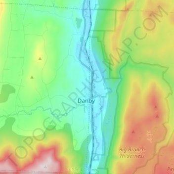
Name: Danby topographic map, elevation, terrain.
Location: Danby, Rutland County, Vermont, 05739, United States (43.30517 -73.12266 43.40301 -72.99342)
Average elevation: 499 m
Minimum elevation: 189 m
Maximum elevation: 1,141 m
Dorset Peak, part of the Taconic range, lies on the town's southern border and reaches an elevation of 3,804 feet (1,159 m). Danby quarry, located near the peak, opened in the early 20th century and is likely the world's largest underground marble quarry. It was reported in 2001 to have a total monthly output of about 1,200 tons of marble, half of which consists of Imperial Danby, a fine architectural marble with a variety of uses. Danby marble has been used in a number of notable buildings, including the United States Supreme Court building and the Jefferson Memorial.
Other topographic maps
Click on a map to view its topography, its elevation and its terrain.
Dutch Hill
United States > Vermont > Rutland County > Danby
Dutch Hill, Danby, Rutland County, Vermont, United States
Average elevation: 528 m
Hortonville
United States > Vermont > Rutland County > Mount Holly
Hortonville, Mount Holly, Rutland County, Vermont, 05758, United States
Average elevation: 497 m
Mount Tabor
United States > Vermont > Rutland County
Mount Tabor, Rutland County, Vermont, United States
Average elevation: 548 m
Fair Haven
United States > Vermont > Rutland County > Fair Haven
Fair Haven, Rutland County, Vermont, United States
Average elevation: 138 m
Wells
United States > Vermont > Rutland County > Wells
Wells, Rutland County, Vermont, 05774, United States
Average elevation: 254 m
Killington
United States > Vermont > Rutland County
Killington, Rutland County, Vermont, 05751, United States
Average elevation: 627 m
Mount Holly
United States > Vermont > Rutland County
Mount Holly, Rutland County, Vermont, United States
Average elevation: 588 m
Hubbardton
United States > Vermont > Rutland County
Hubbardton, Rutland County, Vermont, United States
Average elevation: 241 m
Poultney
United States > Vermont > Rutland County > Poultney
Poultney, Rutland County, Vermont, United States
Average elevation: 198 m
Rutland City
United States > Vermont > Rutland County
Rutland City, Rutland County, Vermont, 05702, United States
Average elevation: 199 m
Green Mountain National Forest
United States > Vermont > Rutland County > Mount Holly
Green Mountain National Forest, Mount Holly, Rutland County, Vermont, United States
Average elevation: 345 m
Chittenden Reservoir
United States > Vermont > Rutland County > Chittenden
Chittenden Reservoir, Chittenden, Rutland County, Vermont, United States
Average elevation: 473 m
Shrewsbury
United States > Vermont > Rutland County > Shrewsbury
Shrewsbury, Rutland County, Vermont, 05738, United States
Average elevation: 522 m
Pittsfield
United States > Vermont > Rutland County > Pittsfield
Pittsfield, Rutland County, Vermont, 05762, United States
Average elevation: 520 m
West Tinmouth
United States > Vermont > Rutland County > Tinmouth > West Tinmouth
West Tinmouth, Tinmouth, Rutland County, Vermont, 05757, United States
Average elevation: 419 m
West Haven
United States > Vermont > Rutland County > West Haven
West Haven, Rutland County, Vermont, 05743, United States
Average elevation: 97 m
Chittenden
United States > Vermont > Rutland County > Chittenden
Chittenden, Rutland County, Vermont, 05737, United States
Average elevation: 473 m
Rutland
United States > Vermont > Rutland County > Rutland
Rutland, Rutland City, Rutland County, Vermont, 05702, United States
Average elevation: 410 m