
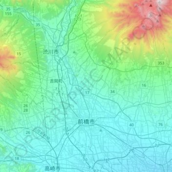
Maebashi topographic map
Interactive map
Click on the map to display elevation.
About this map
Name: Maebashi topographic map, elevation, terrain.
Location: Maebashi, Gunma Prefecture, Japan (36.31621 139.00162 36.56238 139.23014)
Average elevation: 340 m
Minimum elevation: 58 m
Maximum elevation: 1,804 m
Maebashi is located at the foot of Mount Akagi in the northeast corner of the Kantō Plain. It is also surrounded by Mount Haruna and Mount Myōgi. Two rivers run through the city: the Tone River, Japan's second-longest, and the Hirose River. Although it is located inland more than 100 kilometers away from the coast, the elevation of the southern part of the city is only around 100 meters. The highest elevation is 1823 meters above sea level on the south side of Mt. Kurohino, a peak of Mount Akagi. Maebashi is the farthest from the sea (about 120 km) of all Japanese prefectural capitals. The surrounding cities comprise an urban zone of over 1 million people, separated by farmland to the south from the built up areas of Greater Tokyo.
Other topographic maps
Click on a map to view its topography, its elevation and its terrain.
Mount Fuji
Japan > Sunto County > Oyama
Mount Fuji, Oyama, Sunto County, Shizuoka Prefecture, Chubu Region, Japan
Average elevation: 3,261 m
Lake Sanaru
Lake Sanaru, Hamamatsu, Shizuoka Prefecture, Chubu Region, Japan
Average elevation: 16 m
Motoyama
Motoyama, Nagaoka County, Kochi Prefecture, 781-3601, Japan
Average elevation: 679 m
Setouchi
Setouchi, Oshima County, Kagoshima Prefecture, Japan
Average elevation: 26 m
Higashishirakawa
Higashishirakawa, Kamo County, Gifu Prefecture, Chubu Region, 509-1392, Japan
Average elevation: 658 m
Nishikigaoka-chuo Park
Nishikigaoka-chuo Park, Nishikigaoka 2-chome, Aoba Ward, Sendai, Miyagi Prefecture, Japan
Average elevation: 197 m
Katsura Imperial Villa
Katsura Imperial Villa, Road No. 142, Katsura-Kasugacho, Nishikyo Ward, Kyoto, Kyoto Prefecture, 615-8013, Japan
Average elevation: 25 m