
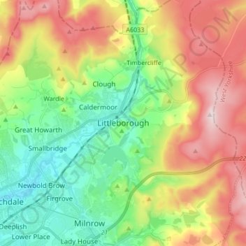
Littleborough topographic map
Interactive map
Click on the map to display elevation.
About this map
Name: Littleborough topographic map, elevation, terrain.
Average elevation: 266 m
Minimum elevation: 122 m
Maximum elevation: 473 m
In the late 18th century, the low-altitude Summit Gap between Littleborough and Walsden was approved as the best route over the Pennines for the Rochdale Canal and the Manchester to Leeds railway; Hollingworth Lake was built at Littleborough's south side as a feeder reservoir to regulate the waters of the canal. This infrastructure encouraged industrialists to modify Littleborough's traditional handloom cloth workshops with a mechanised form of textile production. Attracted to the area's natural resources and modern infrastructure, coal mining, engineering ventures and increasingly large textile mills contributed to Littleborough's population growth and urbanisation, sealing its status as a mill town. Local government reforms established the Littleborough Urban District in 1894 which was governed by its own district council until its abolition in 1974.
Other topographic maps
Click on a map to view its topography, its elevation and its terrain.
London
United Kingdom > England > London
London, Greater London, England, SW1A 2DX, United Kingdom
Average elevation: 42 m
Newcastle upon Tyne
Newcastle upon Tyne, North of Tyne, England, United Kingdom
Average elevation: 57 m
London
London, Greater London, England, United Kingdom
Average elevation: 66 m
Nottingham
United Kingdom > England > Nottinghamshire
Nottingham, England, United Kingdom
Average elevation: 56 m
Dorset
United Kingdom > England > Talbot Village
Dorset, Alder Road, Branksome, Talbot Village, Bournemouth, Christchurch and Poole, South West England, England, BH12 5BJ, United Kingdom
Average elevation: 57 m
Greater Manchester
Greater Manchester, England, United Kingdom
Average elevation: 141 m
Somerset
Somerset, South West England, England, United Kingdom
Average elevation: 87 m
North Norfolk
United Kingdom > England > Norfolk
North Norfolk, Norfolk, England, United Kingdom
Average elevation: 26 m
North Yorkshire
North Yorkshire, Yorkshire and the Humber, England, United Kingdom
Average elevation: 153 m
Copt Hewick
United Kingdom > England > North Yorkshire
Copt Hewick, North Yorkshire, England, United Kingdom
Average elevation: 39 m
Cambridgeshire
Cambridgeshire, Cambridgeshire and Peterborough, England, United Kingdom
Average elevation: 32 m
Hebden Bridge
United Kingdom > England > Calderdale
Hebden Bridge, Calderdale, West Yorkshire, England, HX7 8AT, United Kingdom
Average elevation: 277 m
Cambridge
United Kingdom > England > Cambridge
Cambridge, Cambridgeshire, East of England, England, United Kingdom
Average elevation: 18 m
Winchester
United Kingdom > England > Hampshire
Winchester, Hampshire, England, United Kingdom
Average elevation: 73 m
Poole
United Kingdom > England > Bournemouth, Christchurch and Poole > Merley
Poole, Merley, Bournemouth, Christchurch and Poole, England, United Kingdom
Average elevation: 23 m
Bristol
United Kingdom > England > City of Bristol
Bristol, City of Bristol, West of England, England, United Kingdom
Average elevation: 55 m
West Lutton
United Kingdom > England > North Yorkshire
West Lutton, North Yorkshire, England, YO17 8TA, United Kingdom
Average elevation: 111 m
Wirral
Wirral, Liverpool City Region, England, United Kingdom
Average elevation: 21 m
Sheffield
Sheffield, South Yorkshire, England, United Kingdom
Average elevation: 168 m
Liverpool
Liverpool, Liverpool City Region, England, United Kingdom
Average elevation: 26 m
Milton Keynes
United Kingdom > England > Milton Keynes > Milton Keynes
Milton Keynes, South East England, England, MK9 3AF, United Kingdom
Average elevation: 81 m
Bagby
United Kingdom > England > North Yorkshire
Bagby, North Yorkshire, England, United Kingdom
Average elevation: 48 m
Richmond Park
United Kingdom > England > London
Richmond Park, London Borough of Richmond upon Thames, London, Greater London, England, United Kingdom
Average elevation: 26 m
Bath
United Kingdom > England > Bath and North East Somerset
Bath, Bath and North East Somerset, West of England, England, United Kingdom
Average elevation: 100 m
Connaught Park
United Kingdom > England > Hertfordshire > Hertsmere
Connaught Park, Hertsmere, Hertfordshire, England, WD23 2RA, United Kingdom
Average elevation: 82 m
Holme Fen
United Kingdom > England > Cambridgeshire > East Cambridgeshire > Haddenham
Holme Fen, Haddenham, Aldreth, East Cambridgeshire, Cambridgeshire, Cambridgeshire and Peterborough, England, CB6 3PN, United Kingdom
Average elevation: 4 m
East Riding of Yorkshire
East Riding of Yorkshire, England, United Kingdom
Average elevation: 30 m
Hampshire
Hampshire, South East, England, United Kingdom
Average elevation: 73 m
Manchester
Manchester, Greater Manchester, England, United Kingdom
Average elevation: 66 m
Glastonbury
United Kingdom > England > Glastonbury
Glastonbury, Somerset, South West England, England, BA6 9, United Kingdom
Average elevation: 14 m
Oxford
United Kingdom > England > Oxfordshire
Oxford, Oxfordshire, England, United Kingdom
Average elevation: 81 m
Norwich
United Kingdom > England > Norfolk
Norwich, Norfolk, England, United Kingdom
Average elevation: 28 m
Birmingham
Birmingham, West Midlands Combined Authority, England, United Kingdom
Average elevation: 138 m
Guildford
United Kingdom > England > Surrey
Guildford, Surrey, England, United Kingdom
Average elevation: 74 m
Hull
United Kingdom > England > Kingston upon Hull
Hull, Kingston upon Hull, England, HU1 3RJ, United Kingdom
Average elevation: 21 m
Plymouth
United Kingdom > England > Devon > Plymouth
Plymouth, Devon, South West England, England, PL1 1HH, United Kingdom
Average elevation: 81 m
Cressbrook Dale
United Kingdom > England > Derbyshire > Derbyshire Dales > Litton CP > Litton Mill
Cressbrook Dale, Litton Mill, Litton CP, Cressbrook, Derbyshire Dales, Derbyshire, England, SK17 8ST, United Kingdom
Average elevation: 286 m
Outwood
United Kingdom > England > Bury
Outwood, Bury, Greater Manchester, England, M26 1YW, United Kingdom
Average elevation: 84 m
Ludshott Common
United Kingdom > England > Hampshire > East Hampshire > Bramshott
Ludshott Common, Bramshott, East Hampshire, Hampshire, England, United Kingdom
Average elevation: 162 m
Thornton Watlass
United Kingdom > England > North Yorkshire
Thornton Watlass, North Yorkshire, England, HG4 4AJ, United Kingdom
Average elevation: 102 m
Leeds
United Kingdom > England > Leeds
Leeds, Yorkshire and the Humber, England, LS1 6AL, United Kingdom
Average elevation: 94 m