
Kent topographic map
Interactive map
Click on the map to display elevation.
About this map
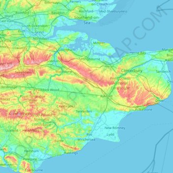
Name: Kent topographic map, elevation, terrain.
Location: Kent, South East, England, United Kingdom (50.91048 0.03352 51.48227 1.45177)
Average elevation: 37 m
Minimum elevation: -3 m
Maximum elevation: 263 m
Kent was also the location of the largest number of art schools in the country during the nineteenth century, estimated by the art historian David Haste, to approach two hundred. This is believed to be the result of Kent being a front line county during the Napoleonic Wars. At this time, before the invention of photography, draughtsmen were used to draw maps and topographical representations of the fields of battle, and after the wars ended many of these settled permanently in the county in which they had been based. Once the idea of art schools had been established, even in small towns in Kent, the tradition continued, although most of the schools were very small one man operations, each teaching a small number of daughters of the upper classes how to draw and make watercolour paintings. Nonetheless, some of these small art schools developed into much larger organisations, including Canterbury College of Art, founded by Thomas Sidney Cooper in 1868, which is today the University for the Creative Arts.
Other topographic maps
Click on a map to view its topography, its elevation and its terrain.
London
United Kingdom > England > London
London, Greater London, England, SW1A 2DX, United Kingdom
Average elevation: 42 m
London
London, Greater London, England, United Kingdom
Average elevation: 66 m
Somerset
Somerset, South West England, England, United Kingdom
Average elevation: 87 m
Newcastle upon Tyne
Newcastle upon Tyne, North of Tyne, England, United Kingdom
Average elevation: 57 m
Nottingham
United Kingdom > England > Nottinghamshire
Nottingham, England, United Kingdom
Average elevation: 56 m
Dorset
United Kingdom > England > Talbot Village
Dorset, Alder Road, Branksome, Talbot Village, Bournemouth, Christchurch and Poole, South West England, England, BH12 5BJ, United Kingdom
Average elevation: 57 m
Greater Manchester
Greater Manchester, England, United Kingdom
Average elevation: 141 m
North Norfolk
United Kingdom > England > Norfolk
North Norfolk, Norfolk, England, United Kingdom
Average elevation: 26 m
North Yorkshire
North Yorkshire, Yorkshire and the Humber, England, United Kingdom
Average elevation: 153 m
Sheffield
Sheffield, South Yorkshire, England, United Kingdom
Average elevation: 168 m
Copt Hewick
United Kingdom > England > North Yorkshire
Copt Hewick, North Yorkshire, England, United Kingdom
Average elevation: 39 m
Cambridgeshire
Cambridgeshire, Cambridgeshire and Peterborough, England, United Kingdom
Average elevation: 32 m
Hebden Bridge
United Kingdom > England > Calderdale
Hebden Bridge, Calderdale, West Yorkshire, England, HX7 8AT, United Kingdom
Average elevation: 277 m
Cambridge
United Kingdom > England > Cambridge
Cambridge, Cambridgeshire, East of England, England, United Kingdom
Average elevation: 18 m
Bristol
United Kingdom > England > City of Bristol
Bristol, City of Bristol, West of England, England, United Kingdom
Average elevation: 55 m
Winchester
United Kingdom > England > Hampshire
Winchester, Hampshire, England, United Kingdom
Average elevation: 73 m
Poole
United Kingdom > England > Bournemouth, Christchurch and Poole > Merley
Poole, Merley, Bournemouth, Christchurch and Poole, England, United Kingdom
Average elevation: 23 m
West Lutton
United Kingdom > England > North Yorkshire
West Lutton, North Yorkshire, England, YO17 8TA, United Kingdom
Average elevation: 111 m
Wirral
Wirral, Liverpool City Region, England, United Kingdom
Average elevation: 21 m
Liverpool
Liverpool, Liverpool City Region, England, United Kingdom
Average elevation: 26 m
Milton Keynes
United Kingdom > England > Milton Keynes > Milton Keynes
Milton Keynes, South East England, England, MK9 3AF, United Kingdom
Average elevation: 81 m
Bagby
United Kingdom > England > North Yorkshire
Bagby, North Yorkshire, England, United Kingdom
Average elevation: 48 m
Richmond Park
United Kingdom > England > London
Richmond Park, London Borough of Richmond upon Thames, London, Greater London, England, United Kingdom
Average elevation: 26 m
City of Bristol
City of Bristol, West of England, England, United Kingdom
Average elevation: 80 m
Bath
United Kingdom > England > Bath and North East Somerset
Bath, Bath and North East Somerset, West of England, England, United Kingdom
Average elevation: 100 m
Connaught Park
United Kingdom > England > Hertfordshire > Hertsmere
Connaught Park, Hertsmere, Hertfordshire, England, WD23 2RA, United Kingdom
Average elevation: 82 m
Holme Fen
United Kingdom > England > Cambridgeshire > East Cambridgeshire > Haddenham
Holme Fen, Haddenham, Aldreth, East Cambridgeshire, Cambridgeshire, Cambridgeshire and Peterborough, England, CB6 3PN, United Kingdom
Average elevation: 4 m
East Riding of Yorkshire
East Riding of Yorkshire, England, United Kingdom
Average elevation: 30 m
Hampshire
Hampshire, South East, England, United Kingdom
Average elevation: 73 m
Manchester
Manchester, Greater Manchester, England, United Kingdom
Average elevation: 66 m
Glastonbury
United Kingdom > England > Glastonbury
Glastonbury, Somerset, South West England, England, BA6 9, United Kingdom
Average elevation: 14 m
Redditch
United Kingdom > England > Worcestershire
Redditch, Worcestershire, England, United Kingdom
Average elevation: 99 m
Oxford
United Kingdom > England > Oxfordshire
Oxford, Oxfordshire, England, United Kingdom
Average elevation: 81 m
Norwich
United Kingdom > England > Norfolk
Norwich, Norfolk, England, United Kingdom
Average elevation: 28 m
Birmingham
Birmingham, West Midlands Combined Authority, England, United Kingdom
Average elevation: 138 m
Guildford
United Kingdom > England > Surrey
Guildford, Surrey, England, United Kingdom
Average elevation: 74 m
Hull
United Kingdom > England > Kingston upon Hull
Hull, Kingston upon Hull, England, HU1 3RJ, United Kingdom
Average elevation: 21 m
Plymouth
United Kingdom > England > Devon > Plymouth
Plymouth, Devon, South West England, England, PL1 1HH, United Kingdom
Average elevation: 81 m
Cressbrook Dale
United Kingdom > England > Derbyshire > Derbyshire Dales > Litton CP > Litton Mill
Cressbrook Dale, Litton Mill, Litton CP, Cressbrook, Derbyshire Dales, Derbyshire, England, SK17 8ST, United Kingdom
Average elevation: 286 m
Outwood
United Kingdom > England > Bury
Outwood, Bury, Greater Manchester, England, M26 1YW, United Kingdom
Average elevation: 84 m
Ludshott Common
United Kingdom > England > Hampshire > East Hampshire > Bramshott
Ludshott Common, Bramshott, East Hampshire, Hampshire, England, United Kingdom
Average elevation: 162 m