Geolocate

Johnson County topographic map

Click on the map to display elevation.

About this map

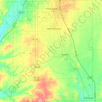
Name: Johnson County topographic map, elevation, terrain.

Location: Johnson County, Indiana, United States (39.34202 -86.25141 39.63850 -85.95087)

Average elevation: 232 m

Minimum elevation: 189 m

Maximum elevation: 310 m

Other topographic maps

Click on a map to view its topography, its elevation and its terrain.

Indianapolis

United States > Indiana > Indianapolis

Indianapolis is within the Tipton Till Plain, a flat to gently sloping terrain underlain by glacial deposits known as till. The lowest point in the city is about 650 feet (198 m) above mean sea level, with the highest natural elevation at about 900 feet (274 m) above sea level. Few hills or short ridges, known…

Average elevation: 241 m

Floyds Knobs

United States > Indiana > Floyd County

Average elevation: 251 m

Metamora

United States > Indiana > Franklin County

Average elevation: 242 m

Samaria

United States > Indiana > Johnson County

Average elevation: 243 m

Caborn

United States > Indiana > Posey County

Average elevation: 126 m

Beech Creek

United States > Indiana > Greene County

Average elevation: 192 m

Newark Village

United States > Indiana > Hamilton County > Carmel

Average elevation: 254 m

Magnolia

United States > Indiana > Crawford County

Average elevation: 197 m

Pin Hook

United States > Indiana > Parke County

Average elevation: 209 m

Sheff

United States > Indiana > Benton County

Average elevation: 232 m

Clymers

United States > Indiana > Cass County

Average elevation: 220 m

Williams

United States > Indiana > Adams County

Average elevation: 252 m

Perth

United States > Indiana > Clay County

Average elevation: 193 m

Otwell

United States > Indiana > Pike County

Average elevation: 150 m

Shelburne

United States > Indiana > Morgan County

Average elevation: 220 m

Thornton

United States > Indiana > Lawrence County

Average elevation: 174 m

Sunset Village

United States > Indiana > Clark County > Owen

Average elevation: 184 m

Samaria

United States > Indiana > Johnson County

Average elevation: 243 m

Alto

United States > Indiana > Howard County > Kokomo

Average elevation: 256 m

South Richmond

United States > Indiana > Wayne County > Richmond

Average elevation: 301 m

Moonlight

United States > Indiana > Steuben County

Average elevation: 297 m

Sleepy Hollow

United States > Indiana > Shelby County

Average elevation: 240 m

Heltonville

United States > Indiana > Lawrence County

Average elevation: 225 m

Messick

United States > Indiana > Henry County

Average elevation: 334 m

Kellerville

United States > Indiana > Dubois County

Average elevation: 181 m

Runyantown

United States > Indiana > Clark County

Average elevation: 183 m

Youngs Creek

United States > Indiana > Orange County

Average elevation: 222 m

Lincoln City

United States > Indiana > Spencer County

Average elevation: 137 m

Solsberry

United States > Indiana > Greene County

Average elevation: 223 m

Times Corner

United States > Indiana > Allen County > Fort Wayne

Average elevation: 244 m

Jalapa

United States > Indiana > Grant County

Average elevation: 247 m

Celestine

United States > Indiana > Dubois County

Average elevation: 185 m

Giro

United States > Indiana > Gibson County

Average elevation: 134 m

West Park

United States > Indiana > Hamilton County > Carmel

Average elevation: 274 m

Circle Park

United States > Indiana > Steuben County > Hamilton

Average elevation: 284 m

Alert

United States > Indiana > Decatur County

Average elevation: 232 m

Alert

United States > Indiana > Decatur County

Average elevation: 232 m

Allens Acres

United States > Indiana > Boone County

Average elevation: 281 m

Samaria

United States > Indiana > Johnson County

Average elevation: 243 m

Idaville

United States > Indiana > White County

Average elevation: 213 m

Mahon

United States > Indiana > Huntington County

Average elevation: 238 m

Mahon

United States > Indiana > Huntington County

Average elevation: 238 m

Lake Windemere

United States > Indiana > Hamilton County > Carmel

Average elevation: 273 m

Green Hill

United States > Indiana > Warren County

Average elevation: 203 m

Bogart Park

United States > Indiana > Vermillion County > Clinton

Average elevation: 150 m

Velpen

United States > Indiana > Pike County

Average elevation: 153 m

Volga

United States > Indiana > Jefferson County

Average elevation: 227 m

Bellfountain

United States > Indiana > Jay County

Average elevation: 286 m

Amity

United States > Indiana > Johnson County

Average elevation: 214 m

Granger

United States > Indiana > Saint Joseph County

Average elevation: 244 m

Bengal

United States > Indiana > Shelby County

Average elevation: 222 m

Butlerville

United States > Indiana > Jennings County

Average elevation: 242 m

Cuzco

United States > Indiana > Dubois County

Average elevation: 181 m

Fish Lake

United States > Indiana > LaPorte County

Average elevation: 215 m

Loree

United States > Indiana > Miami County

Average elevation: 246 m

Unionville

United States > Indiana > Monroe County

Average elevation: 241 m

Derby

United States > Indiana > Perry County

Average elevation: 150 m

Twelve Mile

United States > Indiana > Cass County

Average elevation: 241 m

White Rose

United States > Indiana > Greene County

Average elevation: 156 m

Shannondale

United States > Indiana > Boone County

Average elevation: 265 m

Unionville

United States > Indiana > Monroe County

Average elevation: 241 m

Mechanicsburg

United States > Indiana > Clay County

Average elevation: 212 m

Bucktown

United States > Indiana > Sullivan County

Average elevation: 167 m

Harris

United States > Indiana > Marshall County

Average elevation: 255 m

Monmouth

United States > Indiana > Adams County

Average elevation: 245 m

Bethel

United States > Indiana > Wayne County

Average elevation: 363 m

Sitka

United States > Indiana > White County

Average elevation: 207 m

Queensville

United States > Indiana > Jennings County

Average elevation: 214 m

Green Oak

United States > Indiana > Fulton County

Average elevation: 251 m

Bacon

United States > Indiana > Orange County

Average elevation: 218 m

Aroma

United States > Indiana > Hamilton County

Average elevation: 256 m

Holmesville

United States > Indiana > LaPorte County

Average elevation: 240 m

Eames

United States > Indiana > Warrick County

Average elevation: 122 m

Story

United States > Indiana > Brown County

Average elevation: 195 m

South Boston

United States > Indiana > Washington County

Average elevation: 259 m

Triangle Parkway

United States > Indiana > Lake County > Hammond

Average elevation: 184 m

Utah

United States > Indiana > Dearborn County > Aurora

Average elevation: 167 m

Hillham

United States > Indiana > Dubois County

Average elevation: 208 m

Wooster

United States > Indiana > Scott County

Average elevation: 194 m

London

United States > Indiana > Shelby County

Average elevation: 238 m

Gear up for your next adventure:

🖼️Topographic Map Art - Decorative 3D-effect posters of famous UK peaks and regions
🧭GPS Trackers - Tracking devices for safety and navigation
📍Handheld GPS Navigators - Reliable satellite navigation for hiking and off-road exploration
🎒Backpack Rain Covers - Universal waterproof covers to protect your gear from downpours
👟Women's Trail Running Shoes - Agile footwear for fell running and technical trails

As an Amazon Associate, this site earns from qualifying purchases at no extra cost to you.