Geolocate

Conwy topographic map

Click on the map to display elevation.

About this map

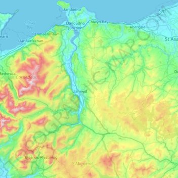
Name: Conwy topographic map, elevation, terrain.

Location: Conwy, Wales, United Kingdom (52.94936 -4.03133 53.34285 -3.45459)

Average elevation: 254 m

Minimum elevation: -1 m

Maximum elevation: 1,058 m

Wales trails, hiking, mountain biking, running and outdoor activities

Other topographic maps

Click on a map to view its topography, its elevation and its terrain.

Snowdon

United Kingdom > Wales > Gwynedd

Snowdon (/ˈsnoʊdən/) or Yr Wyddfa (pronounced [ər ˈʊɨ̞̯ðva] (listen)), is the highest mountain in Wales, at an elevation of 1,085 metres (3,560 ft) above sea level, and the highest point in the British Isles outside the Scottish Highlands. It is located in Snowdonia National Park (Parc Cenedlaethol…

Average elevation: 692 m

Cardiff

United Kingdom > Wales > Cardiff

Average elevation: 55 m

Sennybridge

United Kingdom > Wales > Powys

Average elevation: 261 m

Aberdare

United Kingdom > Wales > Rhondda Cynon Taf

Average elevation: 275 m

Llanberis

United Kingdom > Wales > Gwynedd

Average elevation: 322 m

Tanyfron

United Kingdom > Wales > Wrexham

Average elevation: 178 m

Whitland

United Kingdom > Wales > Carmarthenshire > Whitland

Average elevation: 43 m

Rhossili

United Kingdom > Wales > Swansea

Average elevation: 41 m

Swansea

United Kingdom > Wales > Swansea

Much of Swansea is hilly with the main area of upland being located in the council ward of Mawr. Areas up to 185 metres (607 ft) in elevation range across the central section: Kilvey Hill, Townhill and Llwynmawr separate the centre of Swansea from its northern suburbs. Cefn Bryn, a ridge of high land, is the…

Average elevation: 73 m

Llanelli

United Kingdom > Wales > Carmarthenshire

Average elevation: 41 m

Llangammarch Wells

United Kingdom > Wales > Powys

Average elevation: 239 m

Abercynon

United Kingdom > Wales > Rhondda Cynon Taf

Average elevation: 210 m

Llangennech

United Kingdom > Wales > Carmarthenshire

Average elevation: 37 m

Tywyn

United Kingdom > Wales > Gwynedd

In Samuel Lewis's A Topographical Dictionary of Wales (1833) it is reported that popular horse races were held on land to the north of the town every September. Between 1904 and 1947, Towyn Golf Club (originally the Towyn-on-Sea Golf Club) was also located on land to the north of the town.

Average elevation: 50 m

River Taff

United Kingdom > Wales > Cardiff > Cardiff

Average elevation: 20 m

Neath

United Kingdom > Wales > Neath Port Talbot

Average elevation: 115 m

Llwyndafydd

United Kingdom > Wales > Ceredigion

Average elevation: 148 m

Harlech

United Kingdom > Wales > Gwynedd

Average elevation: 68 m

Cribyn

United Kingdom > Wales > Ceredigion

Average elevation: 196 m

Pantymwyn

United Kingdom > Wales > Flintshire

Average elevation: 213 m

Borth

United Kingdom > Wales > Ceredigion

Average elevation: 28 m

Foel Penolau

United Kingdom > Wales

Average elevation: 423 m

Ysgafell Wen

United Kingdom > Wales

Average elevation: 517 m

Moel Yr Hydd

United Kingdom > Wales

Average elevation: 429 m

Taff

United Kingdom > Wales

Average elevation: 270 m

Fron Goch

United Kingdom > Wales

Average elevation: 196 m

Yr Eifl

United Kingdom > Wales

Average elevation: 257 m

Mynydd Carningli

United Kingdom > Wales

Average elevation: 213 m

Dudwell Mountain

United Kingdom > Wales

Average elevation: 118 m

Penhros Coppice

United Kingdom > Wales

Average elevation: 107 m

Cefn Coch

United Kingdom > Wales

Average elevation: 328 m

Cefn Coch

United Kingdom > Wales

Average elevation: 458 m

Bwlch

United Kingdom > Wales > Powys

Average elevation: 196 m

Gwynedd

United Kingdom > Wales

Average elevation: 332 m

Powys

United Kingdom > Wales

Average elevation: 285 m

Isle of Anglesey

United Kingdom > Wales

Average elevation: 65 m

Bullwell Bay

United Kingdom > Wales

Average elevation: 14 m

Tremadog Bay

United Kingdom > Wales

Average elevation: 0 m

Rhinog Fawr

United Kingdom > Wales > Gwynedd

Average elevation: 434 m

Hay on Wye

United Kingdom > Wales > Powys

Average elevation: 199 m

Pontypridd

United Kingdom > Wales > Pontypridd

Average elevation: 184 m

Tenby

United Kingdom > Wales > Tenby

Average elevation: 21 m

Welshpool

United Kingdom > Wales > Powys

The Mermaid Inn, 28 High Street, was very probably an early 16th-century merchant's house, placed on a burgage plot between the High Street and Alfred Jones Court. The timber-framed building has long storehouse or wing to the rear. The frontage was remodelled c. 1890, by Frank H. Shayler, architect, of…

Average elevation: 156 m

Carmarthen

United Kingdom > Wales > Carmarthenshire

Average elevation: 74 m

Llandeilo

United Kingdom > Wales > Carmarthenshire

Average elevation: 102 m

Llyn Ogwen

United Kingdom > Wales > Gwynedd

Average elevation: 487 m

Baglan

United Kingdom > Wales > Neath Port Talbot

Average elevation: 75 m

Y Garn

United Kingdom > Wales > Gwynedd

Average elevation: 603 m

Tycroes

United Kingdom > Wales > Carmarthenshire

Topographically, the village slopes in a general south west to north east direction thus affording panoramic views of the Black Mountain in the east with its peaks - Tair Cairn 482 m, Garreg Lwyd 616 m and behind them Fan Hir 802 m. To the south there are views from Betws Mountain to Mynydd y Gwair above…

Average elevation: 81 m

Bryneglwys

United Kingdom > Wales > Denbighshire

Average elevation: 319 m

Mathern

United Kingdom > Wales > Monmouthshire

Average elevation: 27 m

Bangor

United Kingdom > Wales > Bangor

Average elevation: 149 m

Newport

United Kingdom > Wales > Newport

Average elevation: 89 m

Wrexham

United Kingdom > Wales > Wrexham

Average elevation: 139 m

Pontardawe

United Kingdom > Wales > Neath Port Talbot

Average elevation: 161 m

Trawsfynydd

United Kingdom > Wales > Gwynedd

Average elevation: 234 m

Aberystwyth

United Kingdom > Wales > Ceredigion

Aberystwyth experiences an oceanic climate (Köppen climate classification Cfb) similar to almost all of the United Kingdom. This is particularly pronounced due to its west coast location facing the Irish Sea. Air undergoes little land moderation and so temperatures closely reflect the sea temperature when…

Average elevation: 39 m

Abergavenny

United Kingdom > Wales > Monmouthshire

Average elevation: 187 m

Caerleon

United Kingdom > Wales > Gwent > Newport > Caerleon

Average elevation: 37 m

Brecon

United Kingdom > Wales > Powys

Average elevation: 216 m

Builth Wells

United Kingdom > Wales > Powys

Average elevation: 232 m

Crickhowell

United Kingdom > Wales > Powys

Average elevation: 253 m

Llandrindod Wells

United Kingdom > Wales > Powys

Average elevation: 247 m

Llanddewi

United Kingdom > Wales > Swansea

Average elevation: 63 m

Banc Y Garth

United Kingdom > Wales > Carmarthenshire

Average elevation: 342 m

Ton-Mawr

United Kingdom > Wales > Neath Port Talbot

Average elevation: 222 m

Beulah

United Kingdom > Wales > Powys

Average elevation: 239 m

Beulah

United Kingdom > Wales > Ceredigion

Average elevation: 139 m

Colwyn Bay

United Kingdom > Wales > Conwy

Average elevation: 68 m

Llandudno

United Kingdom > Wales > Conwy

Average elevation: 19 m

Grosmont

United Kingdom > Wales > Monmouthshire

Average elevation: 128 m

New Brighton

United Kingdom > Wales > Flintshire

Average elevation: 131 m

Bethlehem

United Kingdom > Wales > Carmarthenshire

Average elevation: 115 m

Murton

United Kingdom > Wales > Swansea

Average elevation: 66 m

Abermorddu

United Kingdom > Wales > Flintshire

Average elevation: 124 m

Abergynolwyn

United Kingdom > Wales > Gwynedd

Average elevation: 187 m

Brynithel

United Kingdom > Wales > Blaenau Gwent

Average elevation: 288 m

Rhosgoch

United Kingdom > Wales > Powys

Average elevation: 311 m

Llangattock

United Kingdom > Wales > Powys

Average elevation: 166 m

Llanfilo

United Kingdom > Wales > Powys

Average elevation: 187 m

Oxwich

United Kingdom > Wales > Swansea

Average elevation: 36 m

Nicholaston

United Kingdom > Wales > Swansea

Average elevation: 53 m

Abersychan

United Kingdom > Wales > Torfaen

Average elevation: 299 m

Penpedairheol

United Kingdom > Wales > Monmouthshire > Monkswood

Average elevation: 74 m

Ynystawe

United Kingdom > Wales > Swansea

Average elevation: 63 m

Ynysmeudwy

United Kingdom > Wales > Neath Port Talbot

Average elevation: 126 m

Burgedin

United Kingdom > Wales > Powys > Sarnau

Average elevation: 90 m

Wolf's Castle

United Kingdom > Wales > Pembrokeshire

Average elevation: 87 m

Cwmtydu

United Kingdom > Wales > Ceredigion

Average elevation: 67 m

Prestatyn

United Kingdom > Wales > Denbighshire

Average elevation: 48 m

Evenjobb

United Kingdom > Wales > Powys

Average elevation: 236 m

Tanypistyll

United Kingdom > Wales > Powys

Average elevation: 511 m

Ysbyty Ystwyth

United Kingdom > Wales > Ceredigion

Average elevation: 259 m

Rock

United Kingdom > Wales > Neath Port Talbot > Pont-rhyd-y-fen

Average elevation: 166 m

Gear up for your next adventure:

🥼Base Layers - Thermal base layers for temperature regulation
🦯Walking Poles - Supportive poles for long-distance walking
🕶️Polarized Sunglasses - Reduces glare from snow and water when reading terrain
📻Hand-Crank Emergency Radios - Stay updated on weather warnings in remote areas
🧦Hiking Socks - Breathable socks designed to prevent blisters on long walks

As an Amazon Associate, this site earns from qualifying purchases at no extra cost to you.