Geolocate

Lake Tanganyika topographic map

Interactive map

Click on the map to display elevation.

About this map

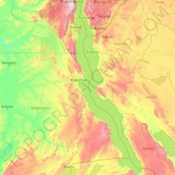
Name: Lake Tanganyika topographic map, elevation, terrain.

Location: Lake Tanganyika, Democratic Republic of the Congo (-8.81109 29.05783 -3.34674 31.20214)

Average elevation: 1,064 m

Minimum elevation: 483 m

Maximum elevation: 3,224 m

Other topographic maps

Click on a map to view its topography, its elevation and its terrain.

Puemba

Democratic Republic of the Congo > Mai-Ndombe > Plateaux

Puemba, Plateaux, Mai-Ndombe, Democratic Republic of the Congo

Average elevation: 465 m

Penanga

Democratic Republic of the Congo > Kwilu > Kwilu

Penanga, Kwilu, Democratic Republic of the Congo

Average elevation: 458 m

Bulo

Democratic Republic of the Congo > Ituri > Djugu

Bulo, Djugu, Ituri, Democratic Republic of the Congo

Average elevation: 2,064 m

Luilu

Democratic Republic of the Congo > Lualaba > Mutshatsha

Luilu, Mutshatsha, Lualaba, Democratic Republic of the Congo

Average elevation: 1,424 m

Musonoie

Democratic Republic of the Congo > Lualaba > Mutshatsha

Musonoie, Mutshatsha, Lualaba, Democratic Republic of the Congo

Average elevation: 1,462 m

Nsele

Democratic Republic of the Congo > Kinshasa

Nsele, Kinshasa, Democratic Republic of the Congo

Average elevation: 431 m

ONL

Democratic Republic of the Congo > Kinshasa

ONL, Kasa-Vubu, Kinshasa, Democratic Republic of the Congo

Average elevation: 293 m

Luizi

Democratic Republic of the Congo > Tanganyika

Luizi, Tanganyika, Democratic Republic of the Congo

Average elevation: 594 m

Mabe

Democratic Republic of the Congo > South Kivu > Kalehe > Kichanga

Mabe, Kichanga, Buhavu (chefferie), Kalehe, South Kivu, Democratic Republic of the Congo

Average elevation: 1,227 m

Kiulu

Democratic Republic of the Congo > Tanganyika

Kiulu, Tanganyika, Democratic Republic of the Congo

Average elevation: 583 m

Kasungami

Democratic Republic of the Congo > Haut-Katanga > Ville de Lubumbashi

Kasungami, Annexe, Ville de Lubumbashi, Haut-Katanga, Democratic Republic of the Congo

Average elevation: 1,238 m

Orientale

Democratic Republic of the Congo

Orientale, Democratic Republic of the Congo

Average elevation: 729 m

Mikalayi

Democratic Republic of the Congo > Central Kasai > Lulua

Mikalayi, Lulua, Central Kasai, Democratic Republic of the Congo

Average elevation: 624 m

Region

Democratic Republic of the Congo > Maniema > Kibombo

Region, Kibombo, Maniema, Democratic Republic of the Congo

Average elevation: 505 m

South Kivu

Democratic Republic of the Congo

South Kivu, Democratic Republic of the Congo

Average elevation: 987 m

Bangwe

Democratic Republic of the Congo > South Kivu > Fizi

Bangwe, Tanganyika, Fizi, South Kivu, Democratic Republic of the Congo

Average elevation: 875 m

Kafwimbi

Democratic Republic of the Congo > Tanganyika

Kafwimbi, Tanganyika, Democratic Republic of the Congo

Average elevation: 995 m

Isiro

Democratic Republic of the Congo > Upper Uele

Isiro, Upper Uele, Democratic Republic of the Congo

Average elevation: 739 m

Parc Naturel de la Nsele (Mangiers)

Democratic Republic of the Congo > Kinshasa

Parc Naturel de la Nsele (Mangiers), Nsele, Kinshasa, Democratic Republic of the Congo

Average elevation: 276 m

Butembo

Democratic Republic of the Congo > North Kivu > Butembo

Butembo, Kimeni, Butembo, North Kivu, Democratic Republic of the Congo

Average elevation: 1,763 m

Bampum Lakenakwa

Democratic Republic of the Congo > Kwilu > Kwilu

Bampum Lakenakwa, Kwilu, Democratic Republic of the Congo

Average elevation: 412 m

Mulo

Democratic Republic of the Congo > North Kivu > Lubero

Mulo, Baswaga, Lubero, North Kivu, Democratic Republic of the Congo

Average elevation: 1,964 m

Kasangulu

Democratic Republic of the Congo > Kongo Central

Kasangulu, Kongo Central, Democratic Republic of the Congo

Average elevation: 479 m

Nyunzu

Democratic Republic of the Congo > Tanganyika

Nyunzu, Tanganyika, Democratic Republic of the Congo

Average elevation: 719 m

Mwenga

Democratic Republic of the Congo > South Kivu

Mwenga, South Kivu, Democratic Republic of the Congo

Average elevation: 1,603 m

Mpweto

Democratic Republic of the Congo > Tanganyika

Mpweto, Tanganyika, Democratic Republic of the Congo

Average elevation: 842 m

Mavivi

Democratic Republic of the Congo > North Kivu > Beni

Mavivi, Beni, North Kivu, Democratic Republic of the Congo

Average elevation: 1,035 m

Goma

Democratic Republic of the Congo > North Kivu

Goma, North Kivu, Democratic Republic of the Congo

Average elevation: 1,613 m

Luozi

Democratic Republic of the Congo > Kongo Central > Luozi

Luozi, Kongo Central, Democratic Republic of the Congo

Average elevation: 202 m

Mukala-Kakesa

Democratic Republic of the Congo > Lomami > Kabinda

Mukala-Kakesa, Kabinda, Lomami, Democratic Republic of the Congo

Average elevation: 610 m

Doruma

Democratic Republic of the Congo > Upper Uele

Doruma, Upper Uele, Democratic Republic of the Congo

Average elevation: 703 m

Vulamba

Democratic Republic of the Congo > North Kivu > Butembo

Vulamba, Butembo, North Kivu, Democratic Republic of the Congo

Average elevation: 1,804 m

Kampene

Democratic Republic of the Congo > Maniema > Pangi

Kampene, Pangi, Maniema, Democratic Republic of the Congo

Average elevation: 684 m

Watsa

Democratic Republic of the Congo > Upper Uele

Watsa, Upper Uele, Democratic Republic of the Congo

Average elevation: 932 m

Loango

Democratic Republic of the Congo > Kongo Central > Mbanza-Ngungu

Loango, Mbanza-Ngungu, Kongo Central, Democratic Republic of the Congo

Average elevation: 522 m

Lukula

Democratic Republic of the Congo > Kongo Central > Lukula

Lukula, Kongo Central, Democratic Republic of the Congo

Average elevation: 144 m

Masisi

Democratic Republic of the Congo > North Kivu

Masisi, North Kivu, Democratic Republic of the Congo

Average elevation: 1,684 m

Kibali

Democratic Republic of the Congo

Kibali, Democratic Republic of the Congo

Average elevation: 966 m

Lukula

Democratic Republic of the Congo > Lomami > Kabinda

Lukula, Kabinda, Lomami, Democratic Republic of the Congo

Average elevation: 678 m

Chute Vampa

Democratic Republic of the Congo > Kongo Central > Songololo

Chute Vampa, Songololo, Kongo Central, Democratic Republic of the Congo

Average elevation: 409 m

Golgota

Democratic Republic of the Congo > Tshuapa > Bokele

Golgota, Bokele, Tshuapa, Democratic Republic of the Congo

Average elevation: 367 m

Kabati

Democratic Republic of the Congo > North Kivu

Kabati, North Kivu, Democratic Republic of the Congo

Average elevation: 1,860 m

Tshuapa

Democratic Republic of the Congo

Tshuapa, Democratic Republic of the Congo

Average elevation: 412 m

Nyiragongo

Democratic Republic of the Congo > North Kivu

Nyiragongo, Bukumu, Nyiragongo, North Kivu, Democratic Republic of the Congo

Average elevation: 3,090 m

Kinsangani

Democratic Republic of the Congo > Kwilu > Kwilu

Kinsangani, Kwilu, Democratic Republic of the Congo

Average elevation: 392 m

Manono

Democratic Republic of the Congo > Tanganyika

Manono, Tanganyika, Democratic Republic of the Congo

Average elevation: 626 m

Massif

Democratic Republic of the Congo > Kongo Central > Songololo

Massif, Songololo, Kongo Central, Democratic Republic of the Congo

Average elevation: 423 m

North Kivu

Democratic Republic of the Congo

North Kivu, Democratic Republic of the Congo

Average elevation: 1,189 m

Kimbembe

Democratic Republic of the Congo > Haut-Katanga > Ville de Lubumbashi

Kimbembe, Annexe, Ville de Lubumbashi, Haut-Katanga, Democratic Republic of the Congo

Average elevation: 1,261 m

Kasanda

Democratic Republic of the Congo > Haut-Katanga > Ville de Lubumbashi > Matoleo

Kasanda, Matoleo, Ruashi, Ville de Lubumbashi, Haut-Katanga, Democratic Republic of the Congo

Average elevation: 1,303 m