Democratic Republic of the Congo topographic map
Interactive map
Click on the map to display elevation.
About this map
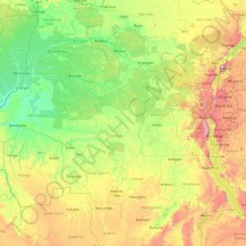
Name: Democratic Republic of the Congo topographic map, elevation, terrain.
Location: Democratic Republic of the Congo (-10.48143 16.32226 4.51857 31.32226)
Average elevation: 737 m
Minimum elevation: 282 m
Maximum elevation: 4,357 m
The tropical climate also produced the Congo River system which dominates the region topographically along with the rainforest it flows through, though they are not mutually exclusive. The name for the Congo state is derived in part from the river. The river basin (meaning the Congo River and all of its myriad tributaries) occupies nearly the entire country and an area of nearly 1,000,000 km2 (390,000 sq mi). The river and its tributaries form the backbone of Congolese economics and transportation. Major tributaries include the Kasai, Sangha, Ubangi, Ruzizi, Aruwimi, and Lulonga.
Other topographic maps
Click on a map to view its topography, its elevation and its terrain.
Todia
Democratic Republic of the Congo > Nord-Ubangi
Todia, Nord-Ubangi, Democratic Republic of the Congo
Average elevation: 481 m
Solola
Democratic Republic of the Congo > Haut-Katanga > Ville de Lubumbashi > Kampemba
Solola, Kampemba, Ville de Lubumbashi, Haut-Katanga, Democratic Republic of the Congo
Average elevation: 1,228 m
Epau
Democratic Republic of the Congo > Ituri > Aru
Epau, Aru, Ituri, Democratic Republic of the Congo
Average elevation: 1,249 m
Inga
Democratic Republic of the Congo > Kongo Central > Seke-Banza
Inga, Seke-Banza, Kongo Central, Democratic Republic of the Congo
Average elevation: 227 m
Puemba
Democratic Republic of the Congo > Mai-Ndombe > Plateaux
Puemba, Plateaux, Mai-Ndombe, Democratic Republic of the Congo
Average elevation: 465 m
Penanga
Democratic Republic of the Congo > Kwilu > Kwilu
Penanga, Kwilu, Democratic Republic of the Congo
Average elevation: 458 m
Bulo
Democratic Republic of the Congo > Ituri > Djugu
Bulo, Djugu, Ituri, Democratic Republic of the Congo
Average elevation: 2,064 m
Luilu
Democratic Republic of the Congo > Lualaba > Mutshatsha
Luilu, Mutshatsha, Lualaba, Democratic Republic of the Congo
Average elevation: 1,424 m
Musonoie
Democratic Republic of the Congo > Lualaba > Mutshatsha
Musonoie, Mutshatsha, Lualaba, Democratic Republic of the Congo
Average elevation: 1,462 m
Nsele
Democratic Republic of the Congo > Kinshasa
Nsele, Kinshasa, Democratic Republic of the Congo
Average elevation: 431 m
ONL
Democratic Republic of the Congo > Kinshasa
ONL, Kasa-Vubu, Kinshasa, Democratic Republic of the Congo
Average elevation: 293 m
Luizi
Democratic Republic of the Congo > Tanganyika
Luizi, Tanganyika, Democratic Republic of the Congo
Average elevation: 594 m
Mabe
Democratic Republic of the Congo > South Kivu > Kalehe > Kichanga
Mabe, Kichanga, Buhavu (chefferie), Kalehe, South Kivu, Democratic Republic of the Congo
Average elevation: 1,227 m
Kiulu
Democratic Republic of the Congo > Tanganyika
Kiulu, Tanganyika, Democratic Republic of the Congo
Average elevation: 583 m
Kasungami
Democratic Republic of the Congo > Haut-Katanga > Ville de Lubumbashi
Kasungami, Annexe, Ville de Lubumbashi, Haut-Katanga, Democratic Republic of the Congo
Average elevation: 1,238 m
Orientale
Democratic Republic of the Congo
Orientale, Democratic Republic of the Congo
Average elevation: 729 m
Mikalayi
Democratic Republic of the Congo > Central Kasai > Lulua
Mikalayi, Lulua, Central Kasai, Democratic Republic of the Congo
Average elevation: 624 m
Region
Democratic Republic of the Congo > Maniema > Kibombo
Region, Kibombo, Maniema, Democratic Republic of the Congo
Average elevation: 505 m
South Kivu
Democratic Republic of the Congo
South Kivu, Democratic Republic of the Congo
Average elevation: 987 m
Bangwe
Democratic Republic of the Congo > South Kivu > Fizi
Bangwe, Tanganyika, Fizi, South Kivu, Democratic Republic of the Congo
Average elevation: 875 m
Kafwimbi
Democratic Republic of the Congo > Tanganyika
Kafwimbi, Tanganyika, Democratic Republic of the Congo
Average elevation: 995 m
Isiro
Democratic Republic of the Congo > Upper Uele
Isiro, Upper Uele, Democratic Republic of the Congo
Average elevation: 739 m
Goma
Democratic Republic of the Congo > North Kivu
Goma, North Kivu, Democratic Republic of the Congo
Average elevation: 1,613 m
Parc Naturel de la Nsele (Mangiers)
Democratic Republic of the Congo > Kinshasa
Parc Naturel de la Nsele (Mangiers), Nsele, Kinshasa, Democratic Republic of the Congo
Average elevation: 276 m
Butembo
Democratic Republic of the Congo > North Kivu > Butembo
Butembo, Kimeni, Butembo, North Kivu, Democratic Republic of the Congo
Average elevation: 1,763 m
Bampum Lakenakwa
Democratic Republic of the Congo > Kwilu > Kwilu
Bampum Lakenakwa, Kwilu, Democratic Republic of the Congo
Average elevation: 412 m
Mulo
Democratic Republic of the Congo > North Kivu > Lubero
Mulo, Baswaga, Lubero, North Kivu, Democratic Republic of the Congo
Average elevation: 1,964 m
Kasangulu
Democratic Republic of the Congo > Kongo Central
Kasangulu, Kongo Central, Democratic Republic of the Congo
Average elevation: 479 m
Nyunzu
Democratic Republic of the Congo > Tanganyika
Nyunzu, Tanganyika, Democratic Republic of the Congo
Average elevation: 719 m
Kampene
Democratic Republic of the Congo > Maniema > Pangi
Kampene, Pangi, Maniema, Democratic Republic of the Congo
Average elevation: 684 m
Mwenga
Democratic Republic of the Congo > South Kivu
Mwenga, South Kivu, Democratic Republic of the Congo
Average elevation: 1,603 m
Mpweto
Democratic Republic of the Congo > Tanganyika
Mpweto, Tanganyika, Democratic Republic of the Congo
Average elevation: 842 m
Mavivi
Democratic Republic of the Congo > North Kivu > Beni
Mavivi, Beni, North Kivu, Democratic Republic of the Congo
Average elevation: 1,035 m
Luozi
Democratic Republic of the Congo > Kongo Central > Luozi
Luozi, Kongo Central, Democratic Republic of the Congo
Average elevation: 202 m
Mukala-Kakesa
Democratic Republic of the Congo > Lomami > Kabinda
Mukala-Kakesa, Kabinda, Lomami, Democratic Republic of the Congo
Average elevation: 610 m
Doruma
Democratic Republic of the Congo > Upper Uele
Doruma, Upper Uele, Democratic Republic of the Congo
Average elevation: 703 m
Vulamba
Democratic Republic of the Congo > North Kivu > Butembo
Vulamba, Butembo, North Kivu, Democratic Republic of the Congo
Average elevation: 1,804 m
Watsa
Democratic Republic of the Congo > Upper Uele
Watsa, Upper Uele, Democratic Republic of the Congo
Average elevation: 932 m
Loango
Democratic Republic of the Congo > Kongo Central > Mbanza-Ngungu
Loango, Mbanza-Ngungu, Kongo Central, Democratic Republic of the Congo
Average elevation: 522 m
Lukula
Democratic Republic of the Congo > Kongo Central > Lukula
Lukula, Kongo Central, Democratic Republic of the Congo
Average elevation: 144 m
Masisi
Democratic Republic of the Congo > North Kivu
Masisi, North Kivu, Democratic Republic of the Congo
Average elevation: 1,684 m
Kibali
Democratic Republic of the Congo
Kibali, Democratic Republic of the Congo
Average elevation: 966 m
Lukula
Democratic Republic of the Congo > Lomami > Kabinda
Lukula, Kabinda, Lomami, Democratic Republic of the Congo
Average elevation: 678 m
Chute Vampa
Democratic Republic of the Congo > Kongo Central > Songololo
Chute Vampa, Songololo, Kongo Central, Democratic Republic of the Congo
Average elevation: 409 m
Golgota
Democratic Republic of the Congo > Tshuapa > Bokele
Golgota, Bokele, Tshuapa, Democratic Republic of the Congo
Average elevation: 367 m
Kabati
Democratic Republic of the Congo > North Kivu
Kabati, North Kivu, Democratic Republic of the Congo
Average elevation: 1,860 m
Nyiragongo
Democratic Republic of the Congo > North Kivu
Nyiragongo, Bukumu, Nyiragongo, North Kivu, Democratic Republic of the Congo
Average elevation: 3,090 m
Tshuapa
Democratic Republic of the Congo
Tshuapa, Democratic Republic of the Congo
Average elevation: 412 m
Kinsangani
Democratic Republic of the Congo > Kwilu > Kwilu
Kinsangani, Kwilu, Democratic Republic of the Congo
Average elevation: 392 m
Bibogobogo
Democratic Republic of the Congo > South Kivu > Fizi > Bibogobogo
Bibogobogo, Mutambala, Fizi, South Kivu, Democratic Republic of the Congo
Average elevation: 1,638 m